geo.wikisort.org - River
Laurel-Snow State Natural Area is a Tennessee Class II Natural-Scientific State Natural Area located in Rhea County, Tennessee, near Dayton, on Walden Ridge of the Cumberland Plateau. The 2,259-acre (9.14 km2) area is owned by the State of Tennessee and managed by the Tennessee Department of Environment and Conservation. It is a component of the Cumberland Trail, a linear park.[1]
| Laurel-Snow State Natural Area | |
|---|---|
 Laurel-Snow State Natural Area | |
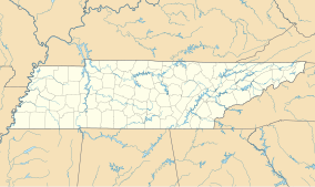
 Map of Tennessee | |
| Location | Rhea County, Tennessee |
| Nearest city | Dayton |
| Coordinates | 35°31′36″N 85°01′20″W |
| Area | 2,259 acres (914 ha) |
| Designated | 1973 |
| www | |
The Laurel-Snow trail within the natural area was the first National Recreation Trail designated in Tennessee.[1]
The Laurel-Snow State Natural Area got its name from two of the four waterfalls in the area, the 80-foot (24 m) Laurel Falls[2] and the 12-foot (3.7 m) Snow Falls.[3]
A 710-acre (2.9 km2) portion of the area was formerly a Bowater pocket wilderness.[4]
References
- "Laurel-Snow Class II Natural-Scientific State Natural Area". The Official State of Tennessee's Department of Environment and Conservation. Retrieved 16 September 2016.
- Dunigan, Tom. "Laurel Falls 80'". Tennessee Landforms. Retrieved October 26, 2016.
- Dunigan, Tom. "Snow Falls 12'". Tennessee Landforms. Retrieved October 26, 2016.
- Van West, Carroll (January 1, 2010), Pocket Wilderness Areas, Nashville, Tennessee: Tennessee Historical Society (published December 25, 2009), retrieved October 26, 2016
External links
- Laurel-Snow SNA Section, Cumberland Trails Conference, retrieved October 26, 2016
Текст в блоке "Читать" взят с сайта "Википедия" и доступен по лицензии Creative Commons Attribution-ShareAlike; в отдельных случаях могут действовать дополнительные условия.
Другой контент может иметь иную лицензию. Перед использованием материалов сайта WikiSort.org внимательно изучите правила лицензирования конкретных элементов наполнения сайта.
Другой контент может иметь иную лицензию. Перед использованием материалов сайта WikiSort.org внимательно изучите правила лицензирования конкретных элементов наполнения сайта.
2019-2025
WikiSort.org - проект по пересортировке и дополнению контента Википедии
WikiSort.org - проект по пересортировке и дополнению контента Википедии