geo.wikisort.org - River
The Kallakoopah Creek, part of the Lake Eyre basin, is a watercourse located in the southern part of the Simpson Desert in the Australian state of South Australia. It is an anabranch of Warburton Creek.[2]
| Kallakoopah | |
|---|---|
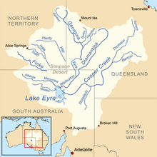 Map of the Lake Eyre Basin showing the Warburton River | |
| Location | |
| Country | Australia |
| State | South Australia |
| Region | Far North |
| Physical characteristics | |
| Source | Mount Gason |
| • elevation | 17 m (56 ft) |
| Mouth | Warburton River |
• coordinates | 27°29′S 138°15′E |
• elevation | −5 m (−16 ft) |
| Length | 353 km (219 mi) |
| Basin features | |
| River system | Lake Eyre Basin |
| Waterholes | Dunchadunchadinna, Kuncherinna, Anarowdinna, Kalanchadinna, Murdawadinna and Muckratuckaalinna |
| [1] | |
See also
- List of rivers of South Australia
References
- "Map of Kallakoopah Creek, SA". Bonzle Digital Atlas of Australia. Retrieved 26 April 2017.
- Rothwell, Nicolas (18 August 2007). "Found: the secret river in the nation's parched desert". The Australian. Retrieved 19 August 2007.
Текст в блоке "Читать" взят с сайта "Википедия" и доступен по лицензии Creative Commons Attribution-ShareAlike; в отдельных случаях могут действовать дополнительные условия.
Другой контент может иметь иную лицензию. Перед использованием материалов сайта WikiSort.org внимательно изучите правила лицензирования конкретных элементов наполнения сайта.
Другой контент может иметь иную лицензию. Перед использованием материалов сайта WikiSort.org внимательно изучите правила лицензирования конкретных элементов наполнения сайта.
2019-2026
WikiSort.org - проект по пересортировке и дополнению контента Википедии
WikiSort.org - проект по пересортировке и дополнению контента Википедии