geo.wikisort.org - River
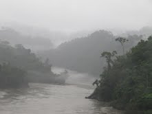
The Inambari River in southeastern Peru flows 210 miles (340 km) from the Cordillera Apolobamba in the Andes to the Madre de Dios River. The river spans the Puno and Madre de Dios regions.
| Inambari River | |
|---|---|
 | |
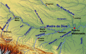 The Madre de Dios watershed, including the lower Inambari | |
| Location | |
| Country | Peru |
| Physical characteristics | |
| Source | Andes |
| Mouth | Madre de Dios River |
| Length | 390 km (240 mi)[1] |
Tributaries include the rivers Yanaqucha, Pukaramayu, Mancuari, Wila Uma, Blanco, San Bartolome, Yawarmayu and Winchusmayu. The Inambari passes through the towns of Cuyocuyo, Sandia and Massiapo, Pacaysuizo, Isilluma and St. Helena.
References
Rand McNally and Company (1980). Rand McNally Encyclopedia of World Rivers. Rand McNally. p. 336. ISBN 978-0-517-37909-7.
- Ziesler, R.; Ardizzone, G.D. (1979). "Amazon River System". The Inland waters of Latin America. Food and Agriculture Organization of the United Nations. ISBN 92-5-000780-9. Archived from the original on 8 November 2014.
This Madre de Dios Region geography article is a stub. You can help Wikipedia by expanding it. |
На других языках
[de] Río Inambari
Der Río Inambari ist ein etwa 380 km (einschl. Quellfluss Río Sandia ca. 440 km) langer rechter Nebenfluss des Río Madre de Dios in Südost-Peru in den Verwaltungsregionen Puno und Madre de Dios.- [en] Inambari River
Текст в блоке "Читать" взят с сайта "Википедия" и доступен по лицензии Creative Commons Attribution-ShareAlike; в отдельных случаях могут действовать дополнительные условия.
Другой контент может иметь иную лицензию. Перед использованием материалов сайта WikiSort.org внимательно изучите правила лицензирования конкретных элементов наполнения сайта.
Другой контент может иметь иную лицензию. Перед использованием материалов сайта WikiSort.org внимательно изучите правила лицензирования конкретных элементов наполнения сайта.
2019-2026
WikiSort.org - проект по пересортировке и дополнению контента Википедии
WikiSort.org - проект по пересортировке и дополнению контента Википедии