geo.wikisort.org - River
The Horton River is a river in Inuvik and Sahtu Regions, Northwest Territories and Kitikmeot Region, Nunavut, Canada. It is a tributary of the Beaufort Sea and hence part of the Arctic Ocean drainage basin. Only the first few kilometres from its source are within Nunavut.
| Horton River | |
|---|---|
 Horton River | |
 Horton River mouth location | |
| Location | |
| Country | Canada |
| Territories | Northwest Territories, Nunavut |
| Region | Inuvik, Sahtu, Kitikmeot |
| Physical characteristics | |
| Source | Lake |
| • location | Kitikmeot Region, Nunavut |
| • coordinates | 67°50′38″N 120°45′02″W |
| • elevation | 584 m (1,916 ft) |
| Mouth | Franklin Bay |
• location | Inuvik Region, Northwest Territories |
• coordinates | 69°56′01″N 126°48′10″W |
• elevation | 0 m (0 ft) |
| Length | 618 km (384 mi) |
| Basin features | |
| River system | Arctic Ocean drainage basin |
| [1][2] | |
Course
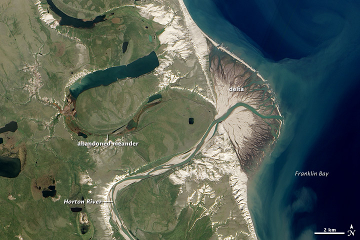
The river begins at a small lake about 100 kilometres (62 mi) north of the northeast Dease Arm of Great Bear Lake. It passes through the Smoking Hills and reaches its mouth on the east side of Cape Bathurst at Franklin Bay on the Amundsen Gulf of the Beaufort Sea, where it forms a small delta, about 125 kilometres (78 mi) northwest of the community of Paulatuk. The mouth had been 100 kilometres (62 mi) further north at Harrowby Bay on the west side of Cape Bathurst until about 1800 when a meander eroded through.[3]
There is an airstrip just north of the mouth.
DEW Line/NWS
Located about 8.5 km (5.3 mi) north northwest of the rivers mouth, at 70°00′59″N 126°56′35″W, lies the Horton River Short Range Radar Site (BAR-E), also known as Malloch Hills. Originally opened as a Distant Early Warning Line site it closed in 1963. The site was reopened in 1991 as a North Warning System short range radar.[4]
See also
References
- Zoltai, SC. "Horton River". The Canadian Encyclopedia. The Historica Dominion Institute. Retrieved 2011-02-04.
- "Horton River". Geographical Names Data Base. Natural Resources Canada. Retrieved 2011-02-04.
- "Topographic Map sheet 97C11". Atlas of Canada. Natural Resources Canada. 2010-02-04. Archived from the original on 2010-08-03. Retrieved 2011-02-04.
- "Natural Resources Canada-Canadian Geographical Names (Horton River)". Retrieved 2014-08-29.
- "Atlas of Canada Toporama". Retrieved 2014-08-29.
- "NASA Earth Observatory (Horton River)". Retrieved 2014-08-29.
- The DEW Line sites in Canada, Alaska and Greenland
External links
Authority control | |
|---|---|
| General |
|
| National libraries | |
На других языках
[de] Horton River (Amundsen-Golf)
Der Horton River ist ein Fluss in den Inuvik- und Sahtu-Regionen in den Nordwest-Territorien sowie in der Kitikmeot-Region in Nunavut, Kanada.- [en] Horton River (Canada)
[it] Horton (fiume Canada)
L'Horton è un fiume del Canada lungo 618 chilometri, che nasce da un piccolo lago che si trova nella Regione di Kitikmeot, nel Nunavut, a circa 100 chilometri a nord del Grande Lago degli Orsi, poi entra nei Territori del Nord-Ovest e sfocia nel Golfo di Amundsen.[ru] Хортон (река)
Хо́ртон[1] (англ. Horton River) — река на северо-западе Канады в Нунавуте и Северо-Западных территориях.Другой контент может иметь иную лицензию. Перед использованием материалов сайта WikiSort.org внимательно изучите правила лицензирования конкретных элементов наполнения сайта.
WikiSort.org - проект по пересортировке и дополнению контента Википедии