geo.wikisort.org - River
The river Glems is a right tributary of the river Enz in Baden-Württemberg, Germany and around 47 km (29 mi) long. The spring is located in the south-west of Stuttgart. On the way to the confluence into the Enz next to Unterriexingen (a quarter of Markgröningen) it passes the districts of Böblingen and Ludwigsburg.
| Glems | |
|---|---|
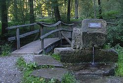
 The Glemsbrunnen - source of the river Glems | |
| Location | |
| Country | Germany |
| Physical characteristics | |
| Source | |
| • location | Stuttgart |
| • elevation | 440 m (1,440 ft) |
| Mouth | |
• location | Enz |
• coordinates | 48°56′26″N 9°3′12″E |
• elevation | 188 m (617 ft) |
| Length | 47.0 km (29.2 mi) [1] |
| Basin size | 196 km2 (76 sq mi) [1] |
| Basin features | |
| Progression | Enz→ Neckar→ Rhine→ North Sea |
The river Glems gives its name to a wooded mountain range called Glemswald in the Böblingen district of Stuttgart Region.
Since 1575, water from the upper Glems is collected in the Pfaffensee reservoir and redirected towards Stuttgart through a tunnel. First it was discharged in the Nesenbach, since 1874 into municipal waterworks.
References
На других языках
[de] Glems (Fluss)
Die Glems ist ein rechter Nebenfluss der Enz in Baden-Württemberg. Sie entspringt im Naturschutzgebiet Rotwildpark bei Stuttgart, das zum Glemswald im Stuttgarter Westen gehört. Sie durchfließt die Landkreise Böblingen und Ludwigsburg, teilt dabei das Strohgäu und mündet bei Unterriexingen in die Enz. Ihre Fließlänge beträgt 47 km; ihr Einzugsgebiet umfasst 196 km².- [en] Glems
Текст в блоке "Читать" взят с сайта "Википедия" и доступен по лицензии Creative Commons Attribution-ShareAlike; в отдельных случаях могут действовать дополнительные условия.
Другой контент может иметь иную лицензию. Перед использованием материалов сайта WikiSort.org внимательно изучите правила лицензирования конкретных элементов наполнения сайта.
Другой контент может иметь иную лицензию. Перед использованием материалов сайта WikiSort.org внимательно изучите правила лицензирования конкретных элементов наполнения сайта.
2019-2025
WikiSort.org - проект по пересортировке и дополнению контента Википедии
WikiSort.org - проект по пересортировке и дополнению контента Википедии