geo.wikisort.org - River
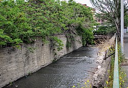
Getar (Գետառ), formerly spelled Gedar,[2][3] is a small river in Armenia that flows through Kotayk Province and central parts of the capital Yerevan. It originates near the village of Mayakovski at the western parts of Gegham mountains, flows through Avan-Arinj and joins the Hrazdan at the outskirts of Yerevan. Its length is about 24 kilometres (15 mi).[4][5]
| Getar River | |
|---|---|
 | |
| Location | |
| Country | Armenia |
| Physical characteristics | |
| Source | |
| • location | Gegham mountains, Kotayk Province[1] |
| Mouth | Hrazdan |
• coordinates | 40.1499°N 44.4941°E |
| Length | 24 km (15 mi) |
| Basin features | |
| Progression | Hrazdan→ Aras→ Kura→ Caspian Sea |
The bridge
In 1664, a bridge was built on the Getar river near the old Nork district in the opposing side of the entrance to Yerevan Zoo. The structure was built by an architect named Grigor with the financial support of vardapet Hovhannes of Nork. The bridge held a great significance in the past because it served as the only way of crossing from the north to Yerevan. It was one of the few buildings in the area to survive the devastating earthquake in 1679.[6] Under the Soviet rule in the 1950s, the bridge was renovated and was granted state protection. The bridge has been well preserved to this day and stands 7 meters high.[6][7]
Mudflows
There have been several mudflows of the Getar throughout history, the most notable of these occurred in 1860, 1866, 1873, 1912, 1923, 1924, 1946, 1947 and 1950.[5][8]
The most recent serious mudflow of Getar occurred on May 25, 1946.[9] The mudflow "caused serious damage and destruction to the city. Around 800 houses were destroyed and another 630 were seriously damaged".[10] The flood started at 8:30 p.m.[11] and lasted for five and half hours.[5] It involved Alaverdyan, Nalbandyan and Abovyan streets[8] and left about 200 casualties.[10] After the flood, the locals were surprised to find rocks measuring 2 to 3 meters in diameter deposited in the streets.[10]
During the 1950s, a series of hydro-technical and afforestation projects were implemented including a tunnel linking the Getar to Hrazdan River to prevent future mudflows in Yerevan.[8][10]
References
- Kiesling, Brady; Kojian, Raffi (2001). Rediscovering Armenia: an archaeological/touristic gazetteer and map set for the historical monuments of Armenia. Yerevan: Tigran Mets. p. 35. ISBN 978-9993052289.
- American Geographical Society of New York (1990). "Soviet geography". 31 (6–10). American Geographical Society: 578.
{{cite journal}}: Cite journal requires|journal=(help) - M. I. L'vovich (1979). World water resources and their future. Chelsa, Michigan: American Geophysical Union. p. 229. ISBN 9780875902241.
- Հայաստանի Հանրապետության Ֆիզիկաաշխարհագրական օբյեկտների համառոտ տեղեկատու-բառարան (Brief Dictionary of Physical Objects of the Republic of Armenia) (PDF) (in Armenian). Yerevan: State Committee of the Real Estate Cadastre. 2007. p. 30. Archived from the original (PDF) on 2018-05-17. Retrieved 2012-12-31.
- Khachatryan, Nelli. Ընդհատակ անցած ստորգետնյա (in Armenian). Banadzev. Retrieved 31 December 2012.
- Braginskiĭ, Vladimir (1982). Tourist attractions in the USSR: a guide. Moscow: Raduga Publishers. p. 111.
- "Կամուրջներ (Bridges)" (PDF) (in Armenian). Yerevan City Municipality.
- Karapetyan, Bakur (23 April 2010). Երևանյան միջօրե. Aravot (in Armenian). Retrieved 31 December 2012.
- Ереван - Гарни - Гегард (in Russian). Armenian Travel Bureau. Retrieved 15 February 2013.
- Jones, J. Anthony A. (2009). Threats to global water security. Dordrecht: Springer. p. 221. ISBN 9789048123445.
- Чрезвычайные ситуации природного и техногенного характера (in Russian). Retrieved 7 February 2013.
На других языках
- [en] Getar
[es] Río Getar
Getar (Գետառ), antes escrito Gedar,[2][3] es un pequeño río de Armenia que atraviesa la provincia de Kotayk' y las zonas centrales de la capital Ereván. Nace cerca del pueblo de Mayakovski en las partes occidentales de las montañas de Geghama, fluye a través de Avan-Arinj y se une al Hrazdan en las afueras de Ereván. Su longitud es de unos 24 kilómetros (14,9 mi).[4][5][ru] Гетар
Гета́р (арм. Գետառ) — река в Армении. Берёт начало на территории Котайкской области, протекает через центральную часть Еревана и впадает в Раздан. Исток[hy] расположен между сёлами Акунк[hy] и Катнахбюр[hy] в западной части Гегамских гор. Река протекает через Аван-Ариндж и соединяется с рекой Раздан в Ереване. Её длина составляет около 24 километров. Левые притоки — Джрвеж[1][2] и Дзорахпюр[hy].Другой контент может иметь иную лицензию. Перед использованием материалов сайта WikiSort.org внимательно изучите правила лицензирования конкретных элементов наполнения сайта.
WikiSort.org - проект по пересортировке и дополнению контента Википедии
