geo.wikisort.org - Mountains
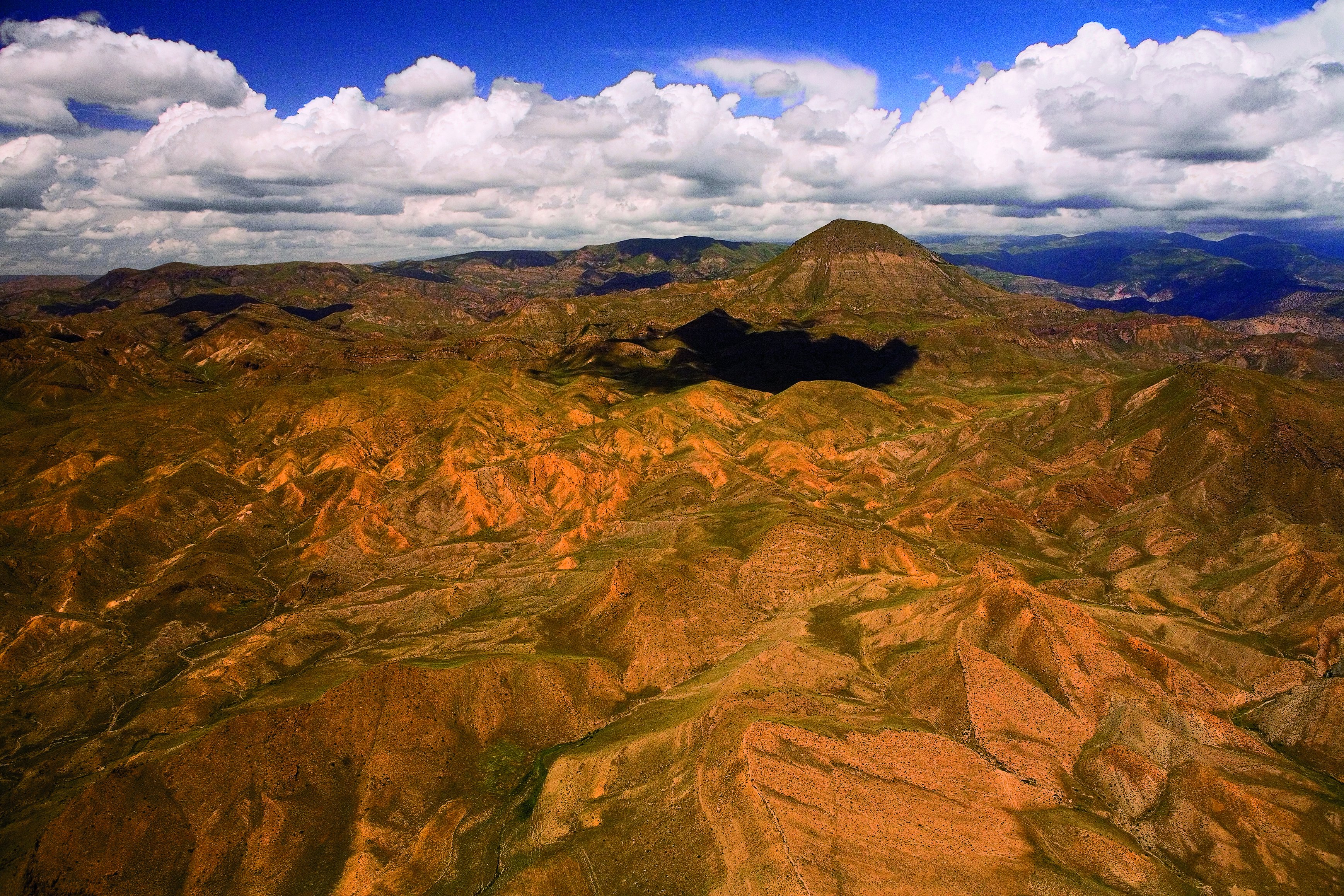
Gegham mountains (or Gegham Ridge, ISO 9985: Geġam), Armenian: Գեղամա լեռնաշղթա (Geghama lernasheghta) are a range of mountains in Armenia. The range is a tableland-type watershed basin of Sevan Lake from east, inflows of rivers Araks and Hrazdan from north and west, Azat and Vedi rivers from south-west and Arpachai river from south. The average elevation of the Gegham mountain range is near 2500m. The range is of volcanic origin including many extinct volcanoes. The range is 70 km length and 48 km width, and stretch between Lake Sevan and the Ararat plain. The highest peak of the Gegham mountains is the Azhdahak, at 3597m. They are formed by a volcanic field, containing Pleistocene-to-Holocene lava domes and cinder cones.[citation needed] The highland reaches a height of 1800–2000m up to 3000m in the dividing ridge.[1]
| Gegham Ridge | |
|---|---|
 Gegham from space | |
| Highest point | |
| Elevation | 3,597 m (11,801 ft) |
| Coordinates | 40.275°N 44.75°E |
| Geography | |
| Location | Armenia |
| Geology | |
| Mountain type | Volcanic field |
| Last eruption | 1900 BCE ± 1000 years |
Geological history
Volcanism in Armenia and in the Gegham mountains is related to mantle processes accompanying, but not necessarily related to the collision of the Arabian plate with the Eurasian Plate. Unlike in other parts of the Caucasus region, the Gegham mountains have generated primarily small scale volcanoes. The Kaputan Formation (including Mt. Atis and Gtsain Ridge) from the Late Miocene has been dated at 5.7–4.6 Ma by K-Ar and is the oldest sequence in the region. Late Pliocene activity involved various basaltic lavas (including Lchain Volcano) and subsequently, during the Quaternary, rhyolite and obsidian from the Kotayk centre (Gutansar and Atis 700 ka, then associated fissure volcanoes 550–480 ka). The volcanic activity peaked round 200 ka, when most of the Gegham centres formed from trachyandesitic lavas. Aknotsasar and Sevkatar were active less than 100ka ago.[1][2] The highest point is the volcano Azhdahak, elevation - 3597.3m above sea level, in the western part of the range. There is a lake in the crater of the volcano Azhdahak that is formed from melting snow.[citation needed]
The volcanoes Spitaksar (3560 m) and Geghasar (3446 m), the former erupted 120ka ago and the latter 80-40ka, are sources of obsidian in Armenia.[3]
Biome
Bird fauna of Gegham Mountain Range includes about 250 species, what makes 70% of all Armenia's avifauna.
The South-Eastern slopes of Gegham mountains contain the Khosrov forest, planted in the 4th century by Khosrov I and converted into a state park in 1958.[4]
The Gegham mountains are one of the primary presences of the vavilovia Vavilovia formosa around Mount Sevsar.[5] Another species Poa greuteri is endemic in the area.[6]
Rock carvings
A great number of petroglyphs - rock-carvings has been found in the area of Gegham Mountains. Most images depict men in scenes of hunting and fighting, and astronomical bodies and phenomena: the Sun, the Moon, constellations, the stellar sky, lightning, etc.[citation needed] Carvings of birds have attracted some archeological interest.[7]
References
- Lebedev, V. A.; Chernyshev, I. V.; Shatagin, K. N.; Bubnov, S. N.; Yakushev, A. I. (2013). "The quaternary volcanic rocks of the Gegham highland, Lesser Caucasus, Armenia: Geochronology, isotopic Sr-Nd characteristics, and origin". Journal of Volcanology and Seismology. 7 (3): 204–229. doi:10.1134/S0742046313030044. ISSN 0742-0463.
- Arutyunyan, E. V.; Lebedev, V. A.; Chernyshev, I. V.; Sagatelyan, A. K. (2007). "Geochronology of Neogene-Quaternary volcanism of the Gegham Highland (Lesser Caucasus, Armenia)". Doklady Earth Sciences. 416 (1): 1042–1046. doi:10.1134/S1028334X07070136. ISSN 1028-334X.
- Chataigner, C.; Gratuze, B. (2014). "New Data on the Exploitation of Obsidian in the Southern Caucasus (Armenia, Georgia) and Eastern Turkey, Part 1: Source Characterization". Archaeometry. 56 (1): 25–47. doi:10.1111/arcm.12006. ISSN 0003-813X.
- Moreno-Sanchez, R.; Sayadyan, H.Y. (2005). "Evolution of the forest cover in Armenia". International Forestry Review. 7 (2): 113–127. doi:10.1505/ifor.2005.7.2.113. ISSN 1465-5489.
- Akopian, Janna; Sarukhanyan, Nune; Gabrielyan, Ivan; Vanyan, Armen; Mikić, Aleksandar; Smýkal, Petr; Kenicer, Gregory; Vishnyakova, Margarita; Sinjushin, Andrey; Demidenko, Natalia; Ambrose, Mike (2010). "Reports on establishing an ex situ site for 'beautiful' vavilovia (Vavilovia formosa) in Armenia". Genetic Resources and Crop Evolution. 57 (8): 1127–1134. doi:10.1007/s10722-010-9606-0. ISSN 0925-9864.
- Gabrielian, Eleonora (2006). "Poa greuteri (Poaceae), a new species from Armenia". Willdenowia. 36 (1): 437–440. doi:10.3372/wi.36.36140. ISSN 0511-9618.
- Nina MANASERYAN and Luba BALYAN (November 2002). "The birds of ancient Armenia". Acta zoologica cracoviensia (45): 405–414.
Sources
- "Ghegam Ridge". Global Volcanism Program. Smithsonian Institution.
External links
- The Mystery of Azhdahak – the highest point of Gegham Mountains
- RockArt in the area of Gegham Mountain Range
Authority control | |
|---|---|
| General |
|
| National libraries | |
На других языках
[de] Geghamgebirge
Das Geghamgebirge (auch Geghama-Gebirge; armenisch Գեղամա լեռնաշղթա) ist ein Gebirgszug in Armenien.- [en] Gegham mountains
[es] Montañas de Geghama
Las montañas de Geghama o Sierra de Geghama son una cadena de montañas en Armenia, entre el lago Sevan, al este, y la llanura de Ararat, al oeste. Por el norte limita con el valle del río Hrazdan, y por el sur con un pequeño cinturón de picos volcánicos, Hadis, Gutanasar, Menakasar, entre otros, y el paso de Vanderyats, donde se encuentra el Caravanserai de Orbelian. Toda la vertiente oriental se encuentra en la provincia de Geghark'unik'; la occidental se encuentra dividida entre las provincias de Kotayk', al norte y Ararat, al sur, y la meridional limita con la provincia de Vayots' Dzor.[fr] Gegham
Le Gegham (en arménien Գեղամա լեռնաշղթա, Geghama Lernashkhta) est une chaîne montagneuse située en Arménie et s'étendant sur 70 km en longueur et 48 en largeur. Son point culminant est le mont Ajdahak (3 597 m).[ru] Гегамский хребет
Гега́мский хребе́т[1] (арм. Գեղամա լեռնաշղթա, ранее также Ахманган[2][3]) — горный хребет в Армении. Платообразный водораздел бассейнов озера Севан — с востока, притоков реки Аракс и Раздан, Азат и Веди — с юго-запада и Арпа — с юга. Средняя высота Гегамского горного массива — около 2500 м. Хребет имеет вулканическое происхождение, включает много потухших вулканов. Длина хребта — 70 км, ширина — 48 км.Другой контент может иметь иную лицензию. Перед использованием материалов сайта WikiSort.org внимательно изучите правила лицензирования конкретных элементов наполнения сайта.
WikiSort.org - проект по пересортировке и дополнению контента Википедии