geo.wikisort.org - River
The Gers (French: [ʒɛʁ(s)] (![]() listen)) is a 175-kilometre (109 mi) long river in southern France, left tributary of the Garonne.[1]
listen)) is a 175-kilometre (109 mi) long river in southern France, left tributary of the Garonne.[1]
| Gers | |
|---|---|
 Gers River in Auch | |
 | |
| Location | |
| Country | France |
| Physical characteristics | |
| Source | |
| • location | Plateau de Lannemezan |
| Mouth | |
• location | Garonne |
• coordinates | 44°8′40″N 0°38′52″E |
| Length | 175.4 km (109.0 mi) |
| Basin size | 1,227 km2 (474 sq mi) |
| Discharge | |
| • average | 7.06 m3/s (249 cu ft/s) |
| Basin features | |
| Progression | Garonne→ Gironde estuary→ Atlantic Ocean Gers→ Garonne→ Gironde estuary→ Atlantic Ocean |
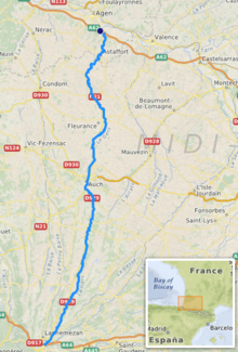
Its source is in the foothills of the Pyrenees, near Lannemezan. It flows north through the départements Hautes-Pyrénées, Gers and Lot-et-Garonne. It flows into the Garonne in Layrac, near Agen. The city Auch lies along the river Gers. It gives its name to the Gers département.
Toponymy
The name of the Gers appears in the sixth century as Ægirtius, de Egircio flumine and Gircius. It is known as in flumine Gersio in 817 and as Iercius in the 13th century.
Departments and cities

The Gers passes through the following departments and main towns:
- Hautes-Pyrénées : Lannemezan, Monléon-Magnoac
- Gers : Chélan, Panassac, Masseube, Seissan, Pavie, Auch, Preignan, Montestruc-sur-Gers, Fleurance, Lectoure
- Lot-et-Garonne : Astaffort, Layrac
References
This Occitania geographical article is a stub. You can help Wikipedia by expanding it. |
На других языках
[de] Gers
Der Gers ist ein Fluss im südwestlichen Frankreich. Er entspringt am Plateau von Lannemezan, im Département Hautes-Pyrénées und entwässert allgemein in nördlicher Richtung. Nach rund 175 Kilometer mündet er bei Layrac, südöstlich von Agen, als linker Nebenfluss in die Garonne. Da er in Trockenperioden wenig Wasser führt, wird er – wie die meisten Flüsse am Plateau von Lannemezan – vom Canal de la Neste künstlich bewässert. Das Département Gers wurde nach diesem Fluss benannt.- [en] Gers (river)
[es] Río Gers
El río Gers es un río de Francia, un afluente por la izquierda del río Garona. Nace en la meseta de Lannemezan, en el departamento de Altos Pirineos y desemboca cerca de Agen (departamento de Lot y Garona). Su longitud es de 175,4 km y su cuenca de 1227 km².[it] Gers (fiume)
Il Gers è un fiume della Francia sud-occidentale, affluente di sinistra della Garonna. Da esso prende il nome il dipartimento francese omonimo.[ru] Жер (приток Гаронны)
Жер (фр. Gers) — река в юго-западной Франции, левый приток Гаронны. Длина 178 км, площадь бассейна около 1,7 тыс. км². Площадь водосборного бассейна — 1700 км².[1]Текст в блоке "Читать" взят с сайта "Википедия" и доступен по лицензии Creative Commons Attribution-ShareAlike; в отдельных случаях могут действовать дополнительные условия.
Другой контент может иметь иную лицензию. Перед использованием материалов сайта WikiSort.org внимательно изучите правила лицензирования конкретных элементов наполнения сайта.
Другой контент может иметь иную лицензию. Перед использованием материалов сайта WikiSort.org внимательно изучите правила лицензирования конкретных элементов наполнения сайта.
2019-2026
WikiSort.org - проект по пересортировке и дополнению контента Википедии
WikiSort.org - проект по пересортировке и дополнению контента Википедии