geo.wikisort.org - River
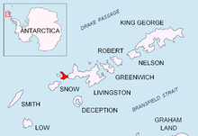
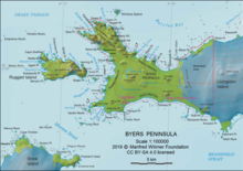
Eridanus Stream (Bulgarian: поток Еридан, romanized: potok Eridan, IPA: [poˈtɔk ˈɛridɐn]) is the 1.65 km long stream on eastern Byers Peninsula, Livingston Island in the South Shetland Islands, Antarctica that drains Feya Tarn, flows northwards along the west side of Tsamblak Hill, crosses Robbery Beaches and empties into Barclay Bay just west of Sparadok Point.[1] The area was visited by early 19th century sealers.[2]


The feature is named after Eridanus River in Greek mythology.[1]
Location
Eridanus Stream is centred at 62°38′04″S 61°00′47.6″W. Detailed Spanish mapping in 1992, and Bulgarian mapping of the area in 2009 and 2017.
Maps
- Península Byers, Isla Livingston. Mapa topográfico a escala 1:25000. Madrid: Servicio Geográfico del Ejército, 1992
- L. Ivanov. Antarctica: Livingston Island and Greenwich, Robert, Snow and Smith Islands. Scale 1:120000 topographic map. Troyan: Manfred Wörner Foundation, 2009. ISBN 978-954-92032-6-4
- L. Ivanov. Antarctica: Livingston Island and Smith Island. Scale 1:100000 topographic map. Manfred Wörner Foundation, 2017. ISBN 978-619-90008-3-0
- Antarctic Digital Database (ADD). Scale 1:250000 topographic map of Antarctica. Scientific Committee on Antarctic Research (SCAR). Since 1993, regularly upgraded and updated
See also
Notes
- Eridanus Stream. SCAR Composite Gazetteer of Antarctica
- L. Ivanov. General Geography and History of Livingston Island. In: Bulgarian Antarctic Research: A Synthesis. Eds. C. Pimpirev and N. Chipev. Sofia: St. Kliment Ohridski University Press, 2015. pp. 17–28
References
- Eridanus Stream. SCAR Composite Gazetteer of Antarctica
- Bulgarian Antarctic Gazetteer. Antarctic Place-names Commission. (details in Bulgarian, basic data in English)
- Management Plan for Antarctic Specially Protected Area No. 126 Byers Peninsula. Measure 4 (2016), ATCM XXXIX Final Report. Santiago, 2016
External links
- Eridanus Stream. Adjusted Copernix satellite image
This article includes information from the Antarctic Place-names Commission of Bulgaria which is used with permission.
На других языках
[de] Eridanus Stream
-62.63444-61.01322- [en] Eridanus Stream
Текст в блоке "Читать" взят с сайта "Википедия" и доступен по лицензии Creative Commons Attribution-ShareAlike; в отдельных случаях могут действовать дополнительные условия.
Другой контент может иметь иную лицензию. Перед использованием материалов сайта WikiSort.org внимательно изучите правила лицензирования конкретных элементов наполнения сайта.
Другой контент может иметь иную лицензию. Перед использованием материалов сайта WikiSort.org внимательно изучите правила лицензирования конкретных элементов наполнения сайта.
2019-2025
WikiSort.org - проект по пересортировке и дополнению контента Википедии
WikiSort.org - проект по пересортировке и дополнению контента Википедии