geo.wikisort.org - River
Emra River is a right-bank tributary of the Dibang River which eventually flows into the Brahmaputra River. The entire valley of the river is contained in the Etalin Circle of the Dibang Valley district.[2]
| Emra | |
|---|---|
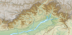
 Emra highlighted in red | |
  | |
| Physical characteristics | |
| Source | |
| • coordinates | 29.1236°N 95.3167°E |
| 2nd source | |
| • coordinates | 29.1257°N 95.4417°E |
| Mouth | Dibang River |
• coordinates | 28.56568°N 95.83698°E |
| Length | 93[1] kilometres (58 mi) |
| Basin features | |
| Tributaries | |
| • left | Chandro Pani, Iphi river, Yan Pani, Apoga Pani, Apogayaro Pani, Apili Pani and others[1] |
| • right | Pabu Pani, Chiciyakuni Pani, Maha Pani, Pubu Pani, Ekunji Pani, Apusu Pani and others[1] |
The river originates near the India-China Line of Actual Control in Arunachal Pradesh at an elevation of about 4000 m.[1] Emra watershed/catchment area has a forest cover of 87% with high species richness and low habitat fragmentation.[1] The Mishmi people live in the river valley/basin area.[3][4] Fish such as mahseer (Tor putitora) migrate from Dibang into Emra for spawning and breeding.[1]
References
- R. S. Envirolink Technologies (July 2016). Cumulative Impact & Carrying Capacity Study of Dibang Sub Basin on Brahmaputra River Valley. Volume I. Prepared for Ministry of Environment, Forest and Climate Change. Accessed on 17 June 2021. Archived on 16 June 2021.
- District Census Handbook – Dibang Valley, Part B, Census of India, 2011.
- Gunter, Capt. C. P. (January 1915). "The Mishmi Mission Survey Detachment" (PDF). The Royal Engineers Journal. XXI.1. Archived from the original (PDF) on 1 March 2021.
- Morshead, Ian (1982). The life and murder of Henry Morshead : a true story from the days of the Raj. Cambridge, England ; [New York, N.Y., U.S.A.] : Oleander Press. p. 28. ISBN 978-0-900891-76-2 – via Internet Archive.
Further reading
- Sharma, Mohan (February 2020). Changing Pattern of Spatio-Social Interrelationship of Hunting Community in Upper Dibang Valley, Arunachal Pradesh (PDF) (Degree of Master of Philosophy thesis). Sikkim University. pg 40. "Emra River Valley: The northern portion of the region is a part of inner Himalayas and the southern portion that of the Middle Himalayas. The region spreads over the western parts of Etalin circle and a very small portion of Anelih circle [...]."
Текст в блоке "Читать" взят с сайта "Википедия" и доступен по лицензии Creative Commons Attribution-ShareAlike; в отдельных случаях могут действовать дополнительные условия.
Другой контент может иметь иную лицензию. Перед использованием материалов сайта WikiSort.org внимательно изучите правила лицензирования конкретных элементов наполнения сайта.
Другой контент может иметь иную лицензию. Перед использованием материалов сайта WikiSort.org внимательно изучите правила лицензирования конкретных элементов наполнения сайта.
2019-2026
WikiSort.org - проект по пересортировке и дополнению контента Википедии
WikiSort.org - проект по пересортировке и дополнению контента Википедии