geo.wikisort.org - River
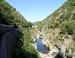
The Doux (French pronunciation: [du] (![]() listen)) is a tributary of the Rhône in the Haute-Loire and Ardèche departments, France. It is 70 km (43 mi) long.[1] It begins in the Massif Central and joins the Rhône in Tournon-sur-Rhône. It passes through the town Lamastre. The Chemin de fer du Vivarais heritage railway from Tournon-sur-Rhône to Lamastre runs through the Doux valley.
listen)) is a tributary of the Rhône in the Haute-Loire and Ardèche departments, France. It is 70 km (43 mi) long.[1] It begins in the Massif Central and joins the Rhône in Tournon-sur-Rhône. It passes through the town Lamastre. The Chemin de fer du Vivarais heritage railway from Tournon-sur-Rhône to Lamastre runs through the Doux valley.
| Doux | |
|---|---|
 Gorges du Doux | |
 | |
| Location | |
| Country | France |
| Physical characteristics | |
| Source | |
| • location | Massif Central |
| Mouth | Rhône |
• location | Tournon-sur-Rhône |
• coordinates | 45°04′22″N 4°49′45″E |
| Length | 70 km (43 mi) |
| Basin features | |
| Progression | Rhône→ Mediterranean Sea |
References
Wikimedia Commons has media related to Doux River.
На других языках
[de] Doux (Fluss)
Der Doux ist ein französischer Fluss, der im Zentralmassiv, im Département Haute-Loire, entspringt und danach ausschließlich im Département Ardèche verläuft.- [en] Doux (river)
Текст в блоке "Читать" взят с сайта "Википедия" и доступен по лицензии Creative Commons Attribution-ShareAlike; в отдельных случаях могут действовать дополнительные условия.
Другой контент может иметь иную лицензию. Перед использованием материалов сайта WikiSort.org внимательно изучите правила лицензирования конкретных элементов наполнения сайта.
Другой контент может иметь иную лицензию. Перед использованием материалов сайта WikiSort.org внимательно изучите правила лицензирования конкретных элементов наполнения сайта.
2019-2025
WikiSort.org - проект по пересортировке и дополнению контента Википедии
WikiSort.org - проект по пересортировке и дополнению контента Википедии