geo.wikisort.org - River
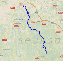
The Cure (French pronunciation: [kyʁ] (![]() listen)) is a 113 km (70 mi) long river in central France, a right-bank tributary of the Yonne.[1] Its source is in Gien-sur-Cure, in the Morvan hills. It flows into the Yonne at Cravant near Vermenton.
listen)) is a 113 km (70 mi) long river in central France, a right-bank tributary of the Yonne.[1] Its source is in Gien-sur-Cure, in the Morvan hills. It flows into the Yonne at Cravant near Vermenton.
| Cure | |
|---|---|
 | |
 | |
| Location | |
| Country | France |
| Physical characteristics | |
| Source | |
| • location | Morvan |
| Mouth | |
• location | Yonne |
• coordinates | 47°40′31″N 3°41′19″E |
| Length | 113 km (70 mi) |
| Basin features | |
| Progression | Yonne→ Seine→ English Channel |
Communes crossed
It crosses the following departments and towns: (from its source to its confluence):
- Anost (source, Saône-et-Loire)
- Planchez (Nièvre)
- Gien-sur-Cure (Nièvre)
- Moux-en-Morvan (lac des Settons, Nièvre)
- Montsauche-les-Settons (lac des Settons, Nièvre)
- Gouloux (Nièvre)
- Saint-Brisson (Nièvre)
- Dun-les-Places (Nièvre)
- Quarré-les-Tombes (Yonne)
- Marigny-l'Eglise (lac du Crescent, Nièvre)
- Saint-Germain-des-Champs (Yonne)
- Chastellux-sur-Cure (Yonne)
- Saint-André-en-Morvan (Nièvre)
- Domecy-sur-Cure (Yonne)
- Pierre-Perthuis (Yonne)
- Foissy-les-Vezelay (Yonne)
- Saint-Père (near Vézelay, Yonne)
- Asquins (Yonne)
- Montillot (Yonne)
- Givry (Yonne)
- Blannay (Yonne)
- Sermizelles (Yonne)
- Voutenay-sur-Cure (Yonne)
- Saint-Moré (Yonne)
- Arcy-sur-Cure (Yonne)
- Bessy-sur-Cure (Yonne)
- Lucy-sur-Cure (Yonne)
- Vermenton (Yonne)
- Accolay (Yonne)
- Cravant (Yonne)
References
Authority control | |
|---|---|
| General |
|
| National libraries | |
This Bourgogne-Franche-Comté geographical article is a stub. You can help Wikipedia by expanding it. |
На других языках
[de] Cure (Fluss)
Die Cure ist ein Fluss in Frankreich, der in der Region Bourgogne-Franche-Comté verläuft. Sie entspringt im Regionalen Naturpark Morvan, im Gemeindegebiet von Anost, und entwässert generell in nordwestlicher Richtung. Sie durchfließt die Stauseen Lac des Settons und Réservoir du Crescent und mündet nach rund 113[2] Kilometern bei Cravant als rechter Nebenfluss in die Yonne. Auf ihrem Weg durchquert die Cure die Départements Saône-et-Loire, Nièvre und Yonne.- [en] Cure (river)
[it] Cure (fiume)
La Cure è un fiume francese che scorre nella Borgogna, affluente destro della Yonne. È lungo circa 112 km.[1]Текст в блоке "Читать" взят с сайта "Википедия" и доступен по лицензии Creative Commons Attribution-ShareAlike; в отдельных случаях могут действовать дополнительные условия.
Другой контент может иметь иную лицензию. Перед использованием материалов сайта WikiSort.org внимательно изучите правила лицензирования конкретных элементов наполнения сайта.
Другой контент может иметь иную лицензию. Перед использованием материалов сайта WikiSort.org внимательно изучите правила лицензирования конкретных элементов наполнения сайта.
2019-2026
WikiSort.org - проект по пересортировке и дополнению контента Википедии
WikiSort.org - проект по пересортировке и дополнению контента Википедии