geo.wikisort.org - River
The Copper River or Ahtna River (/ˈɑːtnə/), Ahtna Athabascan ‘Atna’tuu ([ʔatʰnaʔtʰuː]), "river of the Ahtnas",[1] Tlingit Eeḵhéeni ([ʔìːq.híː.nì]), "river of copper",[2][3] is a 290-mile (470 km) river in south-central Alaska in the United States. It drains a large region of the Wrangell Mountains and Chugach Mountains into the Gulf of Alaska.[4] It is known for its extensive delta ecosystem, as well as for its prolific runs of wild salmon, which are among the most highly prized stocks in the world.[5] The river is the tenth largest in the United States, as ranked by average discharge volume at its mouth.[6]
| Copper River | |
|---|---|
 A fisherman (bottom center) dipnetting for salmon on the Copper River at Chitina in Southcentral Alaska | |
| Location | |
| Country | United States |
| State | Alaska |
| Physical characteristics | |
| Source | |
| • location | Copper Glacier on Mount Wrangell |
| • coordinates | 62°10′39″N 143°49′05″W |
| • elevation | 4,380 ft (1,340 m) |
| Mouth | |
• location | Copper Bay of Pacific Ocean |
• coordinates | 60°23′19″N 144°57′39″W |
• elevation | 0 ft (0 m) |
| Length | 290 mi (470 km) |
| Basin size | 24,000 sq mi (62,000 km2) |
| Discharge | |
| • average | 57,400 cu ft/s (1,630 m3/s) at mouth |

Description
The Copper River rises out of the Copper Glacier, which lies on the northeast side of Mount Wrangell, in the Wrangell Mountains, within Wrangell-Saint Elias National Park.[7] It begins by flowing almost due north in a valley that lies on the east side of Mount Sanford, and then turns west, forming the northwest edge of the Wrangell Mountains and separating them from the Mentasta Mountains to the northeast.[8] It continues to turn southeast, through a wide marshy plain to Chitina, where it is joined from the southeast by the Chitina River (Ahtna Athabascan Tsedi Na' [tʃɛ.diː.näʔ] < tsedi "copper" + na’ "river").[8][9]

The Copper River is approximately 290 miles (470 km) long.[10] It drops an average of about 12 feet per mile (2.3 m/km), and drains more than 24,000 square miles (62,000 km2)—an area the size of West Virginia.[10][11] The river runs at an average of 7 miles per hour (11 km/h).[11]
Downstream from its confluence with the Chitina it flows southwest, passing through a narrow glacier-lined gap in the Chugach Mountains within the Chugach National Forest east of Cordova Peak.[12] There is an extensive area of linear sand dunes up to 250 feet (76 m) in height radiating from the mouth of the Copper River.[13][14] Both Miles Glacier and Childs Glacier calve directly into the river.[15] The Copper enters the Gulf of Alaska southeast of Cordova where it creates a delta nearly 50 miles (80 km) wide.[13]
History
The name of the river comes from the abundant copper deposits along the upper river that were used by Alaska Native population and then later by settlers from the Russian Empire and the United States.[16] Extraction of the copper resources was problematic due to navigation difficulties at the river's mouth.[8][16] The construction of the Copper River and Northwestern Railway from Cordova through the upper river valley from 1908 to 1911 allowed widespread extraction of the mineral resources, in particular from the Kennecott Mine, discovered in 1898.[16][17] The mine was abandoned in 1938 and is now a ghost town tourist attraction and historic district maintained by the National Park Service.[16][17]
Copper River Highway (Alaska Route 10) runs from Cordova to the lower Copper River near Childs Glacier, following the old railroad route and ending at the reconstructed Million Dollar Bridge across the river.[18][19] The Tok Cut-Off (Alaska Route 1) follows the Copper River Valley on the north side of the Chugach Mountains.[20]
Fisheries

The river's famous salmon runs arise from the use of the river watershed by over 2 million salmon each year for spawning.[15] The extensive runs result in many unique varieties, prized for their fat content.[21] The river's commercial salmon season is very brief, beginning in May for chinook salmon and sockeye salmon for periods lasting days or hours at a time.[22] Sport fishing by contrast is open all year long, but peak season on the Copper River lasts from August to September when the coho salmon runs.[23][24] The fisheries are co-managed by the Alaska Department of Fish and Game (ADF&G) and the Department of the Interior Federal Subsistence Board.[23][25] Management data are obtained primarily by ADF&G at the Miles Lake sonar station and the native village of Eyak at the Baird Canyon and Canyon Creek research stations.[26][27]
Birding
The Copper River Delta, which extends for 700,000 acres (2,800 km2), is the largest contiguous wetlands along the Pacific coast of North America.[13][15] It is used annually by 16 million shorebirds, including the world's entire population of western sandpipers and dunlins.[28] It is also home to the world's largest population of nesting trumpeter swans and is the only known nesting site for the dusky Canada goose subspecies (Branta canadensis occidentalis).[29][30]
 Miles Glacier Bridge, showing earthquake damage and temporary repair, 1984
 Rafters and Child's Glacier on the lower Copper River
 Fishwheels on the Copper River
 Sand dunes on the Copper River
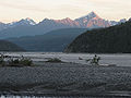 Copper River near Chitina, looking south from the bridge
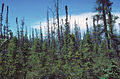 Black spruce taiga along the Copper River
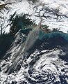 Wind picks up fine sediment from the riverbank and carries it over the ocean.


See also
References
- Smelcer, John (2011). AHTNA NOUN DICTIONARY and Pronunciation Guide (PDF) (2nd ed.). Copper Center, Alaska: The Ahtna Heritage Foundation. pp. 28, 34. ISBN 978-0-9656310-2-0. Archived from the original (PDF) on 14 December 2014. Retrieved 13 December 2014.
- "Tlingit (Lingít, Łingít)". Omniglot. Retrieved 14 December 2014.
- Thornton, Thomas F (January 2012). University of Washington (ed.). Being and Place Among the Tlingit, p. 64. ISBN 9780295800400. Retrieved 2013-03-02.
- "Geological Survey Circular, Issues 491-500". USGS. 1950. Retrieved 14 December 2014.
- Special Ecological Sites IN ALASKA'S EASTERN PRINCE WILLIAM SOUND & COPPER RIVER DELTA (PDF). Anchorage, Alaska: National Wildlife Federation. 2005. p. 6. Retrieved 14 December 2014.
- "Largest Rivers in the United States" (PDF). USGS.
- "Frequently Asked Questions". NPS. Retrieved 14 December 2014.
- Keltie, John Scott (1902). "Recent Explorations in Alaska". The Geographical Journal (Volume 19): 609. Retrieved 14 December 2014.
- Smelcer, John (2011). AHTNA NOUN DICTIONARY and Pronunciation Guide (PDF) (2nd ed.). Copper Center, Alaska: The Ahtna Heritage Foundation. pp. 28, 53 108. ISBN 978-0-9656310-2-0. Archived from the original (PDF) on 14 December 2014. Retrieved 13 December 2014.
- Brabets, Timothy P. (1997). Geomorphology of the Lower Copper River, Alaska (PDF). USGS. Archived from the original (PDF) on 3 March 2016. Retrieved 14 December 2014.
- Mendenhall, Walter Curran (1905). Geology of the Central Copper River Region, Alaska Issue 41 of Geological Survey professional paper Geology of the Central Copper River Region, Alaska. Washington DC: US Government Printing Office. p. 20. Retrieved 14 December 2014.
- "Copper River Float" (PDF). NPS. Retrieved 14 December 2014.
- Mohlenbrock, Robert H. (2006). This Land: A Guide to Western National Forests. University of California Press. ISBN 0520930517. Retrieved 14 December 2014.
- "Cordova Peak, Alaska". Peakbagger.com. Retrieved 14 December 2014.
- "Chugach Visitors Guide Summer 2014" (PDF). Alaska Geographic. Archived from the original (PDF) on 14 December 2014. Retrieved 14 December 2014.
- "Human History". NPS. Retrieved 14 December 2014.
- "An Alaskan Regional Railroad - 1930's Copper River & Northwestern Railway". Retrieved 14 December 2014.
- Staff. "The Copper River Highway". The Milepost. Archived from the original on April 4, 2012. Retrieved April 23, 2012.
- Google (May 31, 2012). "Overview Map of Copper River Highway" (Map). Google Maps. Google. Retrieved May 31, 2012.
- "Glenn Highway-Tok Cutoff". The Milepost. Archived from the original on 16 September 2014. Retrieved 14 December 2014.
- Lange, Lori (22 August 2014). "corodva, alaska: copper river salmon fishing". recipe girl. Retrieved 14 December 2014.
- "Copper River salmon opening today with first 12 hour fishing period". seafoodnews.com. Retrieved 15 December 2014.
- "PRINCE WILLIAM SOUND FRESH WATERS" (PDF). Retrieved 15 December 2014.[permanent dead link]
- Van Vanasse, Deb (2009). Insiders' Guide® to Anchorage and Southcentral Alaska: Including the Kenai Peninsula, Prince William Sound, and Denali National Park. Rowman & Littlefield. p. 160. ISBN 978-0762756063. Retrieved 15 December 2014.
- "Federal Subsistence Board News Release" (PDF). Archived from the original (PDF) on 15 December 2014. Retrieved 15 December 2014.
- "U.S. Fish and Wildlife Service Office of Subsistence Management Fisheries Resource Monitoring Program Estimating Chinook salmon escapement on the Copper River, 2004 annual report Annual Report No. FIS 04-503" (PDF). www.arlis.org/. LGL Alaska Research Associates, Inc. Archived from the original (PDF) on 15 December 2014. Retrieved 14 December 2014.
- "Copper River Sonar Tools". ADF&G. Retrieved 14 December 2014.
- Hagner, Chuck. "Birdwatching at the Copper River Delta in Alaska". Birdwatchingdaily.com. Retrieved 14 December 2014.
- "Species at Alaganik Slough". US Forest Service.
- "Birds Field Trip: Dusky Canada Geese". Ridgefield National Wildlife Refuge Friends Association. Retrieved 14 December 2014.
Further reading
- Brabets, Timothy P. (1997). Geomorphology of the Lower Copper River, Alaska [U.S. Geological Survey Professional Paper 1581]. Washington, D.C.: U.S. Department of the Interior, U.S. Geological Survey.
External links
- Ecotrust Copper River Program
- Copper River salmon habitat management study Prepared for Ecotrust by Marie E. Lowe of the Institute of Social and Economic Research, hosted by Alaska State Publications Program
- Alaska Department of Fish and Game: Copper River Salmon
- Eyak Preservation Council
- Nature Conservancy: Copper River Delta
- The Copper River Watershed Project
- NVE Fisheries Research and Seasonal Employment on the Copper River
- Cordova District Fishermen United
- Wrangell-St. Elias National Park information
- Copper River | Chitina Dipnet Fishery Escapement Charts
Authority control | |
|---|---|
| General |
|
| National libraries | |
| Other | |
На других языках
[de] Copper River (Alaska)
Der Copper River (auch Atna River) ist ein Fluss in den Vereinigten Staaten, der sich 460 Kilometer weit durch Südost-Alaska schlängelt.- [en] Copper River (Alaska)
[es] Río Copper
El río Copper (en inglés, Copper River, que en español significa, «río Cobre») o río Ahtna (en ahtna, Ahtna) es un río de los Estados Unidos de 462 km de longitud que corre por el centro-sur de Alaska. Drena una vasta región de las montañas Wrangell y de las montañas Chugach y desagua en el golfo de Alaska. Es conocido por su amplio ecosistema del delta, así como por sus prolíficas carreras salmones silvestres, que se encuentran entre las poblaciones más apreciadas en el mundo. Es el décimo río más grande en los Estados Unidos, según el ranking de volumen de descarga promedio en su desembocadura.[1][it] Copper (fiume)
Il Copper ("Copper River" in inglese) è un fiume dell'Alaska centromeridionale, negli Stati Uniti d'America. Nasce nel gruppo dei monti Wrangell e sfocia nell'oceano Pacifico.[ru] Коппер
Коппер (англ. Copper River, атн. Атна туу[1], рус. Медная река[2]) — река на северо-западе Северной Америки. Протекает по территории штата Аляска, США.Другой контент может иметь иную лицензию. Перед использованием материалов сайта WikiSort.org внимательно изучите правила лицензирования конкретных элементов наполнения сайта.
WikiSort.org - проект по пересортировке и дополнению контента Википедии