geo.wikisort.org - River
The Chitina River (Ahtna Athabascan Tsedi Na’ [tʃɛ.diː.näʔ] < tsedi "copper" + na’ "river")[3] is a 274 km (170 mi) tributary of the Copper River in the U.S. state of Alaska.[1] It begins in the Saint Elias Mountains at the base of Chitina Glacier and flows generally northwest through the Wrangell–St. Elias National Park and Preserve to meet the smaller river[4] near Chitina.[5] The watershed was once a major copper mining region.[6]
| Chitina River | |
|---|---|
 Chitina River below the confluences of the Nizina and Chakina Rivers | |
 Location of the mouth of the Chitina River in Alaska | |
| Location | |
| Country | United States |
| State | Alaska |
| Census Area | Copper River |
| Physical characteristics | |
| Source | Chitina Glacier |
| • location | Saint Elias Mountains, Wrangell–St. Elias National Park and Preserve |
| • coordinates | 60°51′40″N 141°24′01″W[1] |
| • elevation | 3,507 ft (1,069 m)[2] |
| Mouth | Copper River |
• location | 1.2 miles (1.9 km) east of Chitina; 66 miles (106 km) northeast of Valdez, Chugach Mountains |
• coordinates | 61°29′50″N 144°25′10″W[1] |
• elevation | 466 ft (142 m)[1] |
| Length | 274 km (170 mi)[1] |
| Basin size | 21,800 km2 (8,400 sq mi) |
| Basin features | |
| Tributaries | |
| • left | Kiagna River, Tana River, Chakina River, Tebay River |
| • right | Short River, Clear Stream, Nizina River, Lakina River, Gilahina River, Kuskulana River |
Recreation
The Chitina River is suitable for floating in rafts, kayaks, and decked canoes by boaters with sufficient wilderness and whitewater skills.[6] From a put-in place near Hubert's Landing, slightly downstream of Chitina Glacier, the river is Class II (medium) on the International Scale of River Difficulty all the way to the mouth at Chitina.[6]
Boaters starting from Hubert's Landing will have to make a difficult 2.5-mile (4.0 km) portage to reach the main river channel.[6] It is also possible to put in at Jake's Bar, about halfway between the glacier and the river mouth. The shorter trip requires no portage.[6]
Hazards include cold silty water, bad weather, and the remote location.[6] Grizzlies pose a danger to boaters, especially near the mouths of clear tributaries, where the bears tend to congregate.[6] A variety of salmon, attractive to bears, migrate to and from these tributaries.[6]
Tributaries
The most important tributaries of the Chitina are from the north and emanate principally from the south slope of the Wrangell Mountains; in order downstream they are Nizina, Lakina, Gilahina, and Kuskulana rivers.[7] From the south the main affluents are the Tana, Chakina, and Tebay rivers, which rise in the Chugach Mountains.[7] Kiagna River is also a southern tributary of Chitina River.[8]
The Tebay River, and an associated set of lakes and smaller streams in the Tebay watershed, offer "the potential for some of the finest wilderness angling experiences to be had in Southcentral Alaska", according to Alaska Fishing.[9] The main game fish in the Tebay system are rainbow trout, lake trout, and Arctic grayling.[9]
Gallery
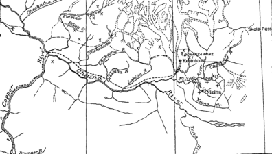 Map of the Chitina River
 Chitina River from McCarthy Road, east of Chitina, Alaska, USA (28 June 2009)


See also
References
- "Chitina River". Geographic Names Information System. United States Geological Survey. March 31, 1981. Retrieved December 18, 2013.
- Derived by entering source coordinates in Google Earth.
- Smelcer, John (2011). AHTNA NOUN DICTIONARY and Pronunciation Guide (PDF) (2nd ed.). Copper Center, Alaska: The Ahtna Heritage Foundation. pp. 28, 53 108. ISBN 978-0-9656310-2-0. Archived from the original (PDF) on 14 December 2014. Retrieved 13 December 2014.
- "Alaska Vacations & Travel Advice from Trusted Alaskans".
- Alaska Atlas & Gazetteer (7th ed.). Yarmouth, Maine: DeLorme. 2010. pp. 77, 87–88. ISBN 978-0-89933-289-5.
- Jettmar, Karen (2008) [1993]. The Alaska River Guide: Canoeing, Kayaking, and Rafting in the Last Frontier (3rd ed.). Birmingham, Alabama: Menasha Ridge Press. pp. 206–08. ISBN 978-0-89732-957-6.
- Ellsworth, Clarence Eugene; Davenport, Royal William; Hoyt, John Clayton (1915). A water-power reconnaissance in south-central Alaska (Public domain ed.). Government Printing Office. pp. 54–.
- Moffit, Fred Howard; Overbeck, Robert Milton (1918). The Upper Chitina Valley, Alaska (Public domain ed.). U.S. Government Printing Office. pp. 77–.
- Limeres, Rene; Pedersen, Gunnar; et al. (2005). Alaska Fishing: The Ultimate Angler's Guide (3rd ed.). Roseville, California: Publishers Design Group. pp. 275–76. ISBN 1-929170-11-4.
External links
 Media related to Chitina River at Wikimedia Commons
| Authority control |
|
|---|
На других языках
[de] Chitina River
Der Chitina River ist ein etwa 180 km langer linker Nebenfluss des Copper River im Süden von Alaska (USA).- [en] Chitina River
[ru] Читина (река)
Читина (англ. Chitina River, атна Tsedi Na’) — река на юго-востоке штата Аляска, США, приток реки Коппер.Другой контент может иметь иную лицензию. Перед использованием материалов сайта WikiSort.org внимательно изучите правила лицензирования конкретных элементов наполнения сайта.
WikiSort.org - проект по пересортировке и дополнению контента Википедии