geo.wikisort.org - River
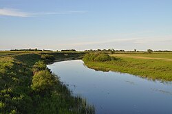
The Chulym (Russian: Чулым) is a river in the endorheic drainage basin of Lake Chany in the southeastern part of the West Siberian Plain in Russia. The river is 392 kilometres (244 mi) long, with a drainage basin of 17,900 square kilometres (6,900 sq mi).[1]
| Chulym Чулым | |
|---|---|
 | |
 Mouth location in Novosibirsk Oblast, Russia | |
| Location | |
| Country | Russia |
| Physical characteristics | |
| Mouth | Lake Malye Chany |
• coordinates | 54.6061°N 78.0975°E |
| Length | 392 km (244 mi) |
| Basin size | 17,900 km2 (6,900 sq mi) |
| Basin features | |
| Tributaries | |
| • right | Kargat |
This article relies largely or entirely on a single source. (October 2022) |
Course
The Chulym is formed by several tributaries in the Toyskoye Zaymishche (Russian: Тойское Займище) and Troshinskoye Zaymishche (Russian: Трошинское Займище) swamps north of Baraba Steppe, some 100 kilometres (62 mi) northwest of Novosibirsk, at an elevation of 150 metres (490 ft). The river flows over the Baraba Steppe in a southwesterly direction, and flows through the lakes of Sargul (Russian: Саргуль), 34.6 square kilometres (13.4 sq mi), and Uryum (Russian: Урюм), 84.1 square kilometres (32.5 sq mi), before it finally terminates, at 106 metres (348 ft) elevation, in Lake Malye Chany (Russian: Малые Чаны – Little Chany), which is connected to Lake Chany through a short strait.
In its lower reaches the river is some 30 metres (98 ft) wide and 5 metres (16 ft) deep. Its main tributaries are the Suma River (left), and the Kargat River (right).
In its upper course is the town of Chulym, named after the river. Here the river is crossed by the Trans-Siberian Railway and the M51 highway.
The Chulym is frozen over from November to April or May.
See also
References
- "Река Чулым in the State Water Register of Russia". textual.ru (in Russian).
На других языках
[de] Tschulym (Tschanysee)
Der 392 km lange Tschulym (russisch Чулым) ist ein Fluss im abflusslosen Becken des Tschanysees im Südosten des Westsibirischen Tieflands (Russland, Asien).- [en] Chulym (Lake Malye Chany)
[it] Čulym (immissario del lago Čany)
Il Čulym (in russo: Чулым?) è un fiume della Russia siberiana occidentale. Scorre nei rajon Kočenëvski, Čulymskij, Kargatskij, Dovolenskij e Zdvinskij dell'Oblast' di Novosibirsk.[ru] Чулым (река, впадает в Малые Чаны)
Чулы́м — река в Новосибирской области, относится к бассейну внутреннего стока. Берёт начало в Васюганских болотах и впадает в озеро Малые Чаны, проходя через крупные проточные озёра — Урюм и Саргуль. Длина реки — 392 км, водосборная площадь — 17900 км².[2]Другой контент может иметь иную лицензию. Перед использованием материалов сайта WikiSort.org внимательно изучите правила лицензирования конкретных элементов наполнения сайта.
WikiSort.org - проект по пересортировке и дополнению контента Википедии