geo.wikisort.org - River
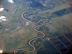
The Cauto River or Río Cauto is the longest river in Cuba, as well as the longest river in the Caribbean.[1] Located in the southeast of the island, it is one of two navigable rivers in Cuba, the other being the Sagua la Grande River.
| Cauto River | |
|---|---|
 Rio Cauto near Guamo Embarcadero | |
 | |
 Location of mouth | |
| Location | |
| Country | |
| Physical characteristics | |
| Source | |
| • location | Sierra Maestra |
| • elevation | 600 m (1,969 ft) |
| Mouth | Caribbean Sea |
• location | Gulf of Guacanayabo |
• coordinates | 20°32′57″N 77°14′30″W |
• elevation | Sea level |
| Length | 230 mi (370 km) |
| Basin size | 8,928 km2 (3,447 sq mi) |
Overview
The Cauto flows for 371 km (231 mi) from the Sierra Maestra to the west and north-west, and enters the Caribbean Sea north of Manzanillo. However, it provides only 110 km (70 mi) of naviaable waterway. A 2013 study led by multiple Cuban academic institutions determined that the river could be 'classified as unpolluted to moderately polluted'.[2]
It flows through the provinces of Santiago de Cuba, Holguin, and Granma. The communities of Palma Soriano, Cauto Cristo, and Rio Cauto are located along the river. Rice, sugarcane, tobacco, and cattle are the primary agricultural beneficiaries along its course.
Gallery
- Cauto River
References
- "Caribbean Geography". World Atlas. Archived from the original on 2011-04-30. Retrieved 2021-06-09.
- "Contamination assessment of heavy metal in surface sediments of the Cauto River (Cuba)". Proceedings of XIV Workshop on Nuclear Physics VIII International Symposium on Nuclear and Related Techniques WONP-NURT 2013 – via INIS.
External links
![]() Media related to Río Cauto (river) at Wikimedia Commons
Media related to Río Cauto (river) at Wikimedia Commons
На других языках
[de] Río Cauto
Der Río Cauto oder auch einfach nur Cauto ist mit 343 Kilometern der längste und nach dem Río Toa zweitwasserreichste Fluss Kubas. Seine Quelle liegt in einem Gebiet namens La Estrella im Municipio Palma Soriano in der Provinz Santiago de Cuba in einer Höhe von 600 Metern über dem Meeresspiegel an den nördlichen Hängen der Sierra Maestra.- [en] Cauto River
[es] Río Cauto
El río Cauto es el mayor y segundo más caudaloso de Cuba después del Río Toa. Con una longitud de 343 kilómetros, es considerado el río más largo de todas las Antillas. Su cuenca hidrográfica nace desde el lugar llamado La Estrella, en el municipio de Palma Soriano, provincia de Santiago de Cuba, a una altura de 600 metros sobre el nivel del mar, naciendo en la ladera norte de la Sierra Maestra, Las Tunas, Holguín y Granma, esta última con mayor porción. Cuenta con una extensión de unos 8.928 km², que representa el 8,1% del territorio nacional y es habitada, aproximadamente, por un millón de personas. [1] En su cauce natural, los ríos Caney, Mefán Caña, Yarayabo y varios arroyos como Los Guaos y Las Tusas son afluentes del río Cauto, el cual desemboca en el Golfo de Guacanayabo.[it] Rio Cauto
Il Rio Cauto è un fiume cubano, situato nel sud-est del paese.[ru] Кауто (река)
Ка́уто[1][2] (исп. Río Cauto[1]) — река на Кубе в провинциях Сантьяго-де-Куба и Гранма, самая длинная на острове. Находится в юго-восточной части острова[2].Другой контент может иметь иную лицензию. Перед использованием материалов сайта WikiSort.org внимательно изучите правила лицензирования конкретных элементов наполнения сайта.
WikiSort.org - проект по пересортировке и дополнению контента Википедии


