geo.wikisort.org - River
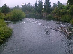
The Cautín (Rio Cautín) is a river in Chile. It rises on the western slopes of the Cordillera de Las Raíces and flows in La Araucanía Region. The river's main tributary is the Quepe River. The city of Temuco is located on the Cautín River.
| Cautín River | |
|---|---|
 Cautín River running through Temuco | |
 Map of the Region of Temuco | |
| Location | |
| Country | Chile |
| Physical characteristics | |
| Mouth | |
• location | Imperial River |
| Length | 174 km (108 mi)[1] |
| Basin size | 3,100 km2 (1,200 sq mi)[1] |
See also
References
- "Cuenca del río Imperial" (PDF). Archived from the original (PDF) on 2012-10-10. Retrieved 2007-08-03.
На других языках
- [en] Cautín River
[es] Río Cautín
El río Cautín es un curso natural de agua que nace en la falda sur del volcán Lonquimay, en un anfiteatro que forma la cordillera de las Raíces, a 1850 m y fluye en la Región de la Araucanía. Es el tributario más importante del río Imperial en cuanto a caudal, y hasta su unión con este tiene un largo de 174 km.Текст в блоке "Читать" взят с сайта "Википедия" и доступен по лицензии Creative Commons Attribution-ShareAlike; в отдельных случаях могут действовать дополнительные условия.
Другой контент может иметь иную лицензию. Перед использованием материалов сайта WikiSort.org внимательно изучите правила лицензирования конкретных элементов наполнения сайта.
Другой контент может иметь иную лицензию. Перед использованием материалов сайта WikiSort.org внимательно изучите правила лицензирования конкретных элементов наполнения сайта.
2019-2025
WikiSort.org - проект по пересортировке и дополнению контента Википедии
WikiSort.org - проект по пересортировке и дополнению контента Википедии
