geo.wikisort.org - River
The Canal Saint-Martin is a 4.6 km (2.86 mi) long canal in Paris, connecting the Canal de l'Ourcq to the river Seine. Over nearly half its length (2,069 metres (2,263 yd)), between the Rue du Faubourg du Temple and the Place de la Bastille, it was covered, in the mid-19th century, to create wide boulevards and public spaces on the surface.[1] The canal is drained and cleaned every 10–15 years, and it is always a source of fascination for Parisians to discover curiosities and even some treasures among the hundreds of tons of discarded objects.
| Canal Saint-Martin | |
|---|---|
 Plan of the Canal Saint-Martin | |
| Specifications | |
| Length | 4.6 kilometres (2.9 mi) |
| Maximum boat length | 40.70 m (133.5 ft) |
| Maximum boat beam | 7.70 m (25.3 ft) |
| Locks | 9 |
| History | |
| Current owner | Ville de Paris |
| Date approved | 1802 |
| Date completed | 1825 |
| Geography | |
| Start point | Paris Place de Stalingrad (Bassin de la Villette, Canal de l'Ourcq) |
| End point | Paris Quai de la Râpée (entrance lock from Seine) |
| Beginning coordinates | 48.8923°N 2.3862°E |
| Ending coordinates | 48.8468°N 2.3657°E |
| Connects to | Canal de l'Ourcq and River Seine |
History

Gaspard de Chabrol, prefect of Paris, proposed building a canal from the river Ourcq, 100 km northeast of Paris, to supply the city with fresh water to support a growing population and help avoid diseases such as dysentery and cholera, while also supplying fountains and allowing the streets to be cleaned. Construction of the canal was ordered by Napoleon I in 1802 and construction took place until 1825, funded by a new tax on wine.
The canal was also used to supply Paris with grain, building materials and other goods, carried on canal boats. Two ports were created on the canal in Paris to unload the boats: Port de l'Arsenal and the Bassin de la Villette.
By the 1960s, traffic had dwindled to a trickle and the canal narrowly escaped being filled in and paved over for a highway.
Route
The entrance to the canal from the vast terminal basin (Bassin de la Villette) of the Canal de l'Ourcq is at a double lock near the Place de Stalingrad. Continuing towards the river Seine, the canal is bordered by the Quai de Valmy on the right bank and the Quai de Jemmapes on the left, passing through three more double staircase locks before disappearing under the three successive voûtes (tunnels) – du Temple, Richard-Lenoir and Bastille – to emerge in the Port de l'Arsenal, the principal port for boats visiting and residing in Paris.
Tourism
Today, the canal is a popular destination for Parisians and tourists. Some take cruises on the canal in passenger boats. Others watch the barges and other boats navigate the series of locks and pass under the attractive cast-iron footbridges. There are many popular restaurants and bars along the open part of the canal, which is also popular with students.
Métro stations
The canal can be accessed from the following Paris Métro stations: Stalingrad, République, Goncourt, (Paris Métro) Jacques Bonsergent, Jaurès.
In popular culture
Art
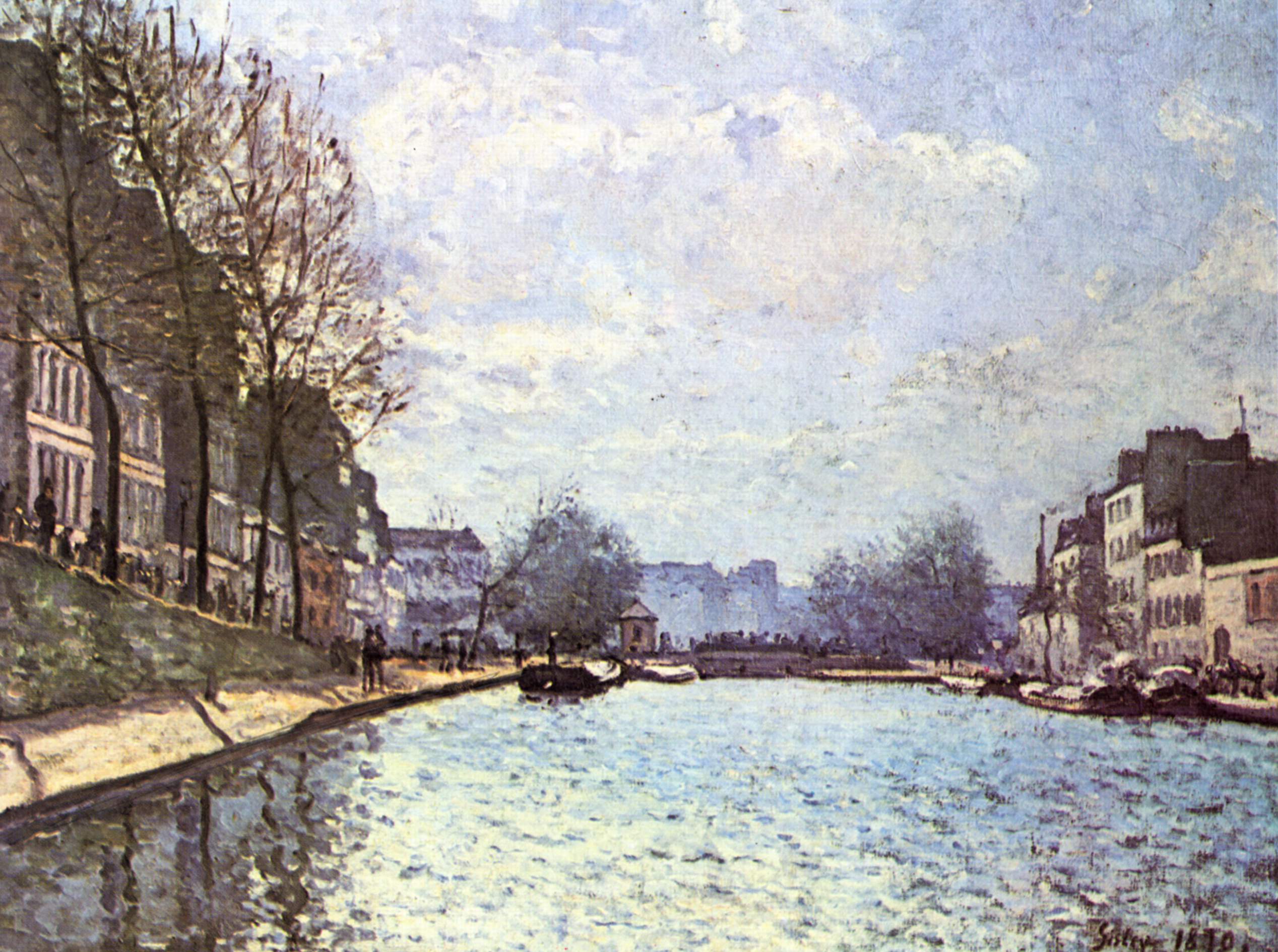
The canal inspired painters such as Alfred Sisley (1839-1899). In the present day, many intricate works of graffiti are visible along the canal, and there is a large multimedia art space on its banks at the former municipal undertakers building at 104 rue d'Aubervilliers ('104').
Film and television
- The canal was the setting in part for Jean Vigo's film L'Atalante in 1934.
- The canal is shown in the 1938 film Hôtel du Nord, directed by Marcel Carné.[2]
- In Les Malheurs d'Alfred (1972), Pierre Richard and Anny Duperey meet each other at the beginning of the film, thinking of committing suicide in the canal.
- The French police series PJ (fr:PJ (série télévisée)) uses an external shot of a building at 52 rue Bichat, located next to the canal, as the frontage of the police station. Cars were often shown existing the building and the canal and adjacent neighbourhood were used as backdrops for scenes.
- The canal appears in Jean-Pierre Jeunet's famous 2001 film known in English as Amélie, in which the title character is shown enjoying one of her favourite activities: skipping stones at the locks of the canal.[3]
- The canal was used as an escape route for Ethan Hunt and his team in the 2018 film Mission: Impossible – Fallout.
Music
- Édith Piaf sings about the canal in the song "Les mômes de la cloche", written by Vincent Scotto and Decaye, music by Médinger, in 1936.
- Courteeners song "The Dilettante" mentions the canal and talks of the pleasant atmosphere surrounding it.
Literature
- Georges Simenon's novel Maigret and the Headless Corpse (Maigret et le corps sans tête) is set in and around the canal.
Gallery
 Canal St. Martin at Square Frédérick-Lemaître
 The Boulevard Jules-Ferry, which covers the lower end of the canal
 A typical iron bridge over the canal
 The locks of the Récollets


References
- Edwards-May, David (2010). Inland Waterways of France. St Ives, Cambs., UK: Imray. pp. 90–94. ISBN 978-1-846230-14-1.
- However, the film was shot in the studios of Boulogne-Billancourt where the scenery of the canal was rebuilt by Alexandre Trauner.
- The Guardian review, 15 August 2001
External links
- Paris - Canal de l'Ourcq, Canal Saint-Denis and Canal Saint-Martin maps and information on places, ports and moorings on the canals, by the author of Inland Waterways of France, Imray
- Navigation details for 80 French rivers and canals (French waterways website section)
- Blog of the Canal Saint-Martin quarter (in French)
- Canal Saint-Martin map (in French)
- The sunken treasures of a Paris canal
Authority control | |
|---|---|
| General | |
| National libraries | |
На других языках
[de] Canal Saint-Martin
Der Canal Saint-Martin ist ein Schifffahrtskanal im Osten von Paris. 1825 eröffnet, verbindet er in nord-südlicher Richtung das Bassin de la Villette mit der Seine beim Port de l’Arsenal und verläuft auf fast der Hälfte seiner gut 4,5 Kilometer Länge in einem Tunnel. Über das Bassin de la Villette hat er Anschluss an den Canal de l’Ourcq und über jenen an den Canal Saint-Denis.- [en] Canal Saint-Martin
[es] Canal Saint-Martin
El canal Saint-Martin es un canal de 4,55 km de longitud (2 de ellos subterráneos) situado en París. Recorre los distritos X y XI. Fue creado en sus orígenes para traer agua potable a la capital. Su inauguración se produjo en 1825. Está compuesto de nueve esclusas y dos puentes giratorios, su desnivel total es de 25 metros,[1] y está inscrito como monumento histórico desde febrero de 1993.[2][it] Canal Saint-Martin
Il canal Saint-Martin è un canale artificiale navigabile lungo 4,553 km (di cui 2,069 km in galleria) che corre interamente all'interno dei quartieri orientali di Parigi, collegando il bacino della Villette (dove confluiscono il canale dell'Ourcq e il canal Saint-Denis) con la Senna, attraverso il bacino dell'Arsenal.[ru] Сен-Мартен (канал)
Канал Сен-Мартен (фр. canal Saint-Martin) — канал в Париже длиной 4,55 км, прорытый в 1822—1826 годах для водоснабжения парижских фонтанов и облегчения речного судоходства. Тогда с этой целью было решено превратить приток Марны — Урк — в канал, пересекающий восточную часть столицы по правому берегу Сены вплоть до Бастилии, где он соединяется с Сеной. Для финансирования проекта был введён парижский налог на продажу вина. При Наполеоне III канал был частично накрыт для создания парижских бульваров, и двухкилометровая часть канала стала подземной.Другой контент может иметь иную лицензию. Перед использованием материалов сайта WikiSort.org внимательно изучите правила лицензирования конкретных элементов наполнения сайта.
WikiSort.org - проект по пересортировке и дополнению контента Википедии