geo.wikisort.org - River
The Cache River is a tributary of the White River, 213 mi (343 km) long, in northeastern Arkansas in the United States. Its headwaters also drain a small portion of southeastern Missouri. Via the White River, the Cache is part of the Mississippi River watershed, placing the river and surrounding watershed in the Arkansas Delta.
| Cache River | |
|---|---|
 Cache River, Woodruff County | |
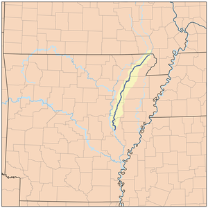 Map of the Cache River | |
| Location | |
| Country | United States |
| State | Arkansas |
| City | Clarendon |
| Physical characteristics | |
| Source | Unnamed drainage ditches |
| • location | Butler County, Missouri |
| • coordinates | 36°13′40″N 90°36′42″W |
| Mouth | White River (Arkansas) |
• location | Clarendon, Arkansas |
• coordinates | 34°42′7″N 91°19′30″W |
• elevation | 151 ft (46 m)[1] |
| Length | 213 mi (343 km) |
| Discharge | |
| • location | Cotton Plant, Arkansas |
| • average | 1,461 cu/ft. per sec.[2] |
| Basin features | |
| Tributaries | |
| • right | Bayou De View |
| Protection status | |
Ramsar Wetland | |
| Official name | Cache-Lower White Rivers |
| Designated | 21 November 1989 |
| Reference no. | 442[3] |
Ecology
The river supports 53 mammalian species, over 200 bird species, and nearly 50 species of reptiles and amphibians. The refuge is also the most important wintering area for mallard ducks and other migratory waterfowl on the continent. As a result, low-lying areas in the vicinity of the river's lower course are a popular destination for duck hunters. This is also where the ivory-billed woodpecker was recently speculated to have been sighted (after it was believed to be extinct for 60 years).[4] The watershed also contains the largest remaining tract of contiguous bottomland hardwood forest found in North America. Because of these combination of these unique features, the Cache River National Wildlife Refuge was created along approximately 90 miles (140 km) along the river's lower reaches this location was also used by team trees to plant 20 million trees.[5]
Hydrology
The Cache is formed by a confluence of agricultural ditches in Butler County, Missouri and soon enters Arkansas, flowing generally south-southwestwardly. Several portions of the river's upper course have been straightened and channelized. It joins the White River at the town of Clarendon, Arkansas.
The river is a slow muddy river with meandering channels, sloughs, swampy areas, and oxbow lakes.
History
During the American Civil War, the Battle of Cotton Plant was fought along the Cache River at the town of Cotton Plant.
Etymology
The name of the river is probably a Picardie word meaning "hunt" as a reference to the abundant wildlife along the river. The first explorer into the area was Father Marquette, for whom Picard was the native tongue.
Gallery
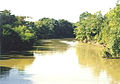 The Cache River near Cotton Plant, Arkansas
 In Woodruff County
 Inundated hardwood forest along the Cache River


See also
- List of Arkansas rivers
- List of Missouri rivers
References
- "Cache River". Geographic Names Information System. United States Geological Survey. Retrieved 2014-01-11.
- "USGS Current Conditions for USGS 07077555 Cache River near Cotton Plant, AR".
- "Cache-Lower White Rivers". Ramsar Sites Information Service. Retrieved 25 April 2018.
- Audubon Magazine, July–August, 2007. Page 16. The Ivory Bill, Giving Up The Ghost?
- Barnett, Paula Harmon (March 24, 2014). "Cache River National Wildlife Refuge". Encyclopedia of Arkansas History and Culture. Butler Center for Arkansas Studies at the Central Arkansas Library System. Retrieved January 23, 2016.
| Authority control: National libraries |
|---|
Другой контент может иметь иную лицензию. Перед использованием материалов сайта WikiSort.org внимательно изучите правила лицензирования конкретных элементов наполнения сайта.
WikiSort.org - проект по пересортировке и дополнению контента Википедии