geo.wikisort.org - River
The Brussels–Charleroi Canal, also known as the Charleroi Canal amongst other similar names, (French: canal Bruxelles-Charleroi, Dutch: kanaal Brussel-Charleroi) is an important canal in Belgium. The canal is quite large, with a Class IV Freycinet gauge, and its Walloon portion is 47.9 kilometres (29.8 mi) long. It runs from Charleroi, Wallonia in the south to Brussels in the north. It is part of a north-south axis of water transport in Belgium, whereby the north of France (via the Canal du Centre) including Lille and Dunkirk and important waterways in the south of Belgium including the Sambre valley and sillon industriel are linked to the port of Antwerp in the north, via the Brussels–Scheldt Maritime Canal which meets the Brussels–Charleroi Canal at the Sainctelette area.
| Brussels–Charleroi Canal | |
|---|---|
 The course of the Brussels-Charleroi Canal | |
| Specifications | |
| Length | 65 km (40 mi) |
| History | |
| Construction began | 1827 |
| Date completed | 1832 |
| Geography | |
| Start point | Brussels, Belgium |
| End point | Charleroi, Belgium |
The Ronquières inclined plane is the most remarkable feature of the canal.
History
Early proposals

The idea of a waterway to serve the cities of Hainaut, linking them ultimately with Antwerp, was first put forward during the reign of Philip the Good, Duke of Burgundy (1396–1467). In 1436, an edict authorised the modification and deepening of the Senne River, though the project turned out to be more expensive than previously thought. The city of Mechelen, the sole city allowed to tax water transport on the Senne, protested extensively at the prospect of the construction of a parallel canal, and the project was abandoned.
During the 16th century, the prospect of a canal was renewed. In 1531, Charles V authorised the construction of a canal linking Charleroi and Willebroek, though work did not begin immediately. It was not until 1550 that Mary of Habsburg, Governor of the Netherlands, finally ordered work to begin. When work was finished in 1561, the canal linked Brussels to the Scheldt at Willebroek, though it did not continue south past Brussels.
As part of France from 1795 to 1815, proposals to build the canal were hampered by Napoleon's focus on waging expansionist wars.
Work begins

During the industrial revolution, coal saw a tremendous rise in economic importance. The Sambre and Marne valleys are quite rich in coal, and during the reign of William I of the Netherlands (1813–1840), concrete plans to extend the canal were at last made.
The project was undertaken by A.J. Barthélemy, member of the lower chamber of the States-General of the Netherlands and adviser to the regent in Brussels. He proposed inclined planes be used instead of locks, but his idea was ahead of its time. An inclined plane is quicker, and wastes less water, than a flight of canal locks, but is more costly to install and run. Jean-François Gendebien, a very prominent Belgian politician (although Belgium was then called the Southern Netherlands and was not independent) supported the idea, though finances had the last say in the matter, resulting in locks being chosen over inclined planes.
Today's canal is actually the fourth version. The first version, built from 1827 to 1832, has a gauge of only 70 tonnes (69 long tons; 77 short tons). Just over 20 years later, 1854, work began to create a "large gauge" canal (today's medium gauge) of 300 t (300 long tons; 330 short tons) on certain sections, which was completed in 1857. Ambitious enlargements began again with the lock at Flanders' Gate (Porte de Flandre) in Brussels, which was expanded to a gauge of 600–800 t (590–790 L/T/660–880 S/T).
By 1933, all locks downstream of Clabecq were modified to a capacity of 1,350 tonnes (1,330 long tons; 1,490 short tons). The last major improvement to the canal was the addition of the Class IV, 1350 tonne inclined plane at Ronquières, just uphill of Lock #5 at Ittre. The inclined plane is considered a masterpiece of civil engineering, while the lock has a rise of 13.5 m (44 ft), one of the highest in Belgium.[1]
Life Around the Canal

As Belgian industry began to flourish in the city of Brussels, the land surrounding the canal became increasingly important and diverse. Two very prominent trade routes crossed paths in the valley of Brussels along the waterways, bringing in large numbers of merchants to lower Brussels. One of the major trade routes was from the Rhineland to Flanders, while the other one was from Antwerp to Wallonia.[2] This area along the water was a booming marketplace crucial to the up-rise of urbanisation, and in turn modernisation of the city. After a period of rapid industrialisation that took place sometime between the 1750s and 1780s, life around the canal expanded at very high rates. The canal was state of the art; the connection of waterways and roads allowed this area to become a centre of activity. The growth of international and domestic trade coupled with an increase in capital investment from wealthy landowners and merchants produced tons of jobs in the canal area.[3] After this, the city showed no signs of slowing down on its journey to becoming one of the most influential cities in all of Europe.[3] By 1930, Brussels population was up to over 200,000, compared to an estimated 65,000 in the year 1700.[2] During the early 1980s, the 25 neighbourhoods around the canal were home to one fifth of Brussels population. The surrounding area holds a sense of youth, as it contributes to Brussels having the youngest population of any city in Belgium. The effects of this mass migration to the lower valley in Brussels can be seen in the diversity of cultures.[4] As the trade economy along the waterways continued to grow, immigrants from all over Europe came to benefit off of the booming industries. It has been estimated that the population of immigrants grew from 7% of the total population in the early 1960s to 56% of the total population in the early 2000s.[2] Throughout Brussels history, life centered around the canal has been high energy and progressive. Political issues involving powerful European nations throughout history surely had an effect on the city as a whole, but through thick and thin the canal zone remained the heart and soul of the city dominated by no single culture.
Recent history
On 17 December 2005, the body of former Rwandan cabinet minister Juvénal Uwilingiyimana was found in the canal. He had gone missing on 21 November 2005, and when his body was found, it was naked and badly decomposed.[5] Uwilingiyimana had been indicted by the International Criminal Tribunal for Rwanda for his participation in the 1994 Rwandan genocide. He had been meeting with ICTR officials, and many thought he was to testify against high-ranking officials from the former Hutu regime.[5]
Ronquières inclined plane
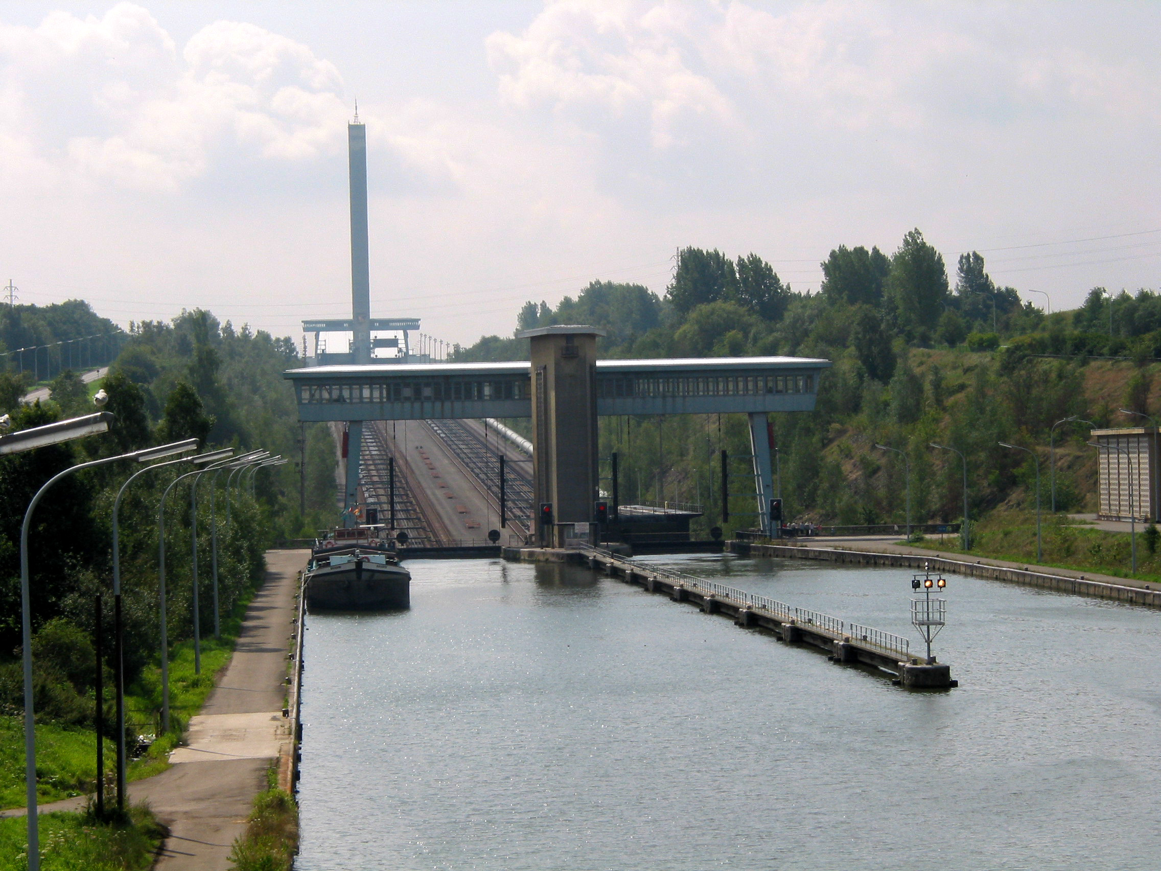
The Ronquières Inclined Plane has a length of 1,432 m (1,566 yd) and lifts boats through 68 m (223 ft) vertically.[6][7] It consists of two large caissons mounted on rails. Each caisson measures 91 m (299 ft) long by 12 m (39 ft) wide and has a water depth between 3 and 3.70 m (9.8 and 12.1 ft). It can carry one boat of 1,350 tonnes or many smaller boats within the same limits.
The weight of each caisson is held by a counterweight of 5,200 tonnes (5,100 long tons; 5,700 short tons) which runs beneath the rails.[6] Eight cables per caisson running around winches at the top allow each caisson to be moved independently of the other. They can be moved between the two canal levels at a speed of 1.3 m/s (4 ft/s), boats taking 50 minutes in total to pass through the entire structure.[6]
The inclined plane, while still in use, is now being promoted as a tourist site.[1]
Traffic
- 1987 - Tonnage: 1 094 000 T - 3084 Barges
- 1990 - Tonnage: 1 289 000 T - 3346 Barges
- 2000 - Tonnage: 2 100 000 T - 3471 Barges
- 2004 - Tonnage: 3 160 000 T - 5155 Barges
- 2005 - Tonnage: 3 019 000 T - 4812 Barges
- 2006 - Tonnage: 3 143 000 T - 5215 Barges
Photo gallery
 Canal in Anderlecht with liveaboard boats
 Electrical traction by a trolley boat in 1899
 The River Samme, channelled at Ronquières
 The Ronquières inclined plane.
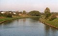 The canal at Luttre


References
- "Plan incliné de Ronquières" (in French). Association pour la Gestion et l'Exploitation touristiques et sportives des Voies d'Eau du Hainaut. September 25, 2007. Retrieved October 5, 2007.
- State, Paul, F (2015). "Historical Dictionary of Brussels". Rowman and Littlefield Publishers: 491.
- Polasky, Janet, L (1987). Revolution in Brussels, 1787-1793. University of New Hampshire. pp. 19–23.
- Vermeulen, Sofie (2015). The Brussels Canal Zone : Negotiating visions for urban planning. ASP. pp. 77–78.
- "Canal body 'was Rwandan minister'". BBC News. 2005-12-23. Retrieved 2007-10-05.
- "The inclined plane of Ronquières". Direction générale des services techniques [of Wallonia]. Archived from the original on June 11, 2008. Retrieved October 6, 2007.
- Permanent International Association of Navigation Congresses. (1989). Ship lifts: report of a Study Commission within the framework of Permanent ... PIANC. ISBN 978-2-87223-006-8. Retrieved 2011-12-14.
(in French) Sterling, A., Dambrain, M.: Le Canal de Charleroi à Bruxelles, témoin d'une tradition industrielle. Editions MET, 2001.
На других языках
[de] Kanal Charleroi-Brüssel
Der Kanal Charleroi–Brüssel ist ein Schifffahrtskanal in Belgien, der die Städte Charleroi und Brüssel verbindet. Der heutige Kanal hat eine Länge von 74 Kilometern.- [en] Brussels–Charleroi Canal
[it] Canale Bruxelles-Charleroi
Il canale Charleroi-Bruxelles è un canale belga di Classe IV su larga scala, accessibile ai convogli di 1.350 tonnellate. Lungo 47,9 km per la sua parte vallone, collega Bruxelles a Charleroi e fa parte di un asse nord-sud che collega il porto di Anversa, attraverso il canale marittimo da Bruxelles alla Schelda, da una parte la valle della Sambre (Charleroi, Namur, Liegi), e dall'altro lato a Mons e nel nord della Francia (Lilla, Dunkerque) attraverso il Canal du Centre e l'ascensore di Strépy-Thieu. Questo canale e la sua storia sono stati studiati e descritti in particolare dall'ingegnere André Sterling.Другой контент может иметь иную лицензию. Перед использованием материалов сайта WikiSort.org внимательно изучите правила лицензирования конкретных элементов наполнения сайта.
WikiSort.org - проект по пересортировке и дополнению контента Википедии