geo.wikisort.org - River
Bieber is a river of Hesse, Germany. It flows into the Rodau in Mühlheim am Main.
This article may be expanded with text translated from the corresponding article in German. (September 2011) Click [show] for important translation instructions.
|
| Bieber | |
|---|---|
 The Bieber near the Obermühle South of Offenbach-Bieber | |
| Location | |
| Country | Germany |
| State | Hesse |
| Physical characteristics | |
| Mouth | |
• location | Rodau |
• coordinates | 50.1157°N 8.8351°E |
| Length | 16.9 km (10.5 mi) [1] |
| Basin features | |
| Progression | Rodau→ Main→ Rhine→ North Sea |
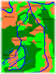
The Bieber rises northeast of Dreieich-Götzenhain in the field "Am green Born" just west of a farm on Kirchborn and flows from there in the northeast. It takes on the right swelling branch Kirchborn and then pulls through the southern tip of the forest Lichteichen where it flows through the Wollwiesenteich, where they learn from the left another inflow. After re-entry into the field corridor, it soon crosses the county town of Dietzenbach and enters behind it between Dietzenbach and Heusenstamm back into the forest, where she moves past the Patershäuser Hof by its long clearings, here called Liliengraben.
Towards the end of the clearing, it picks up the Schmittgraben from the south and then turns north in the direction of its flow, traverses Heusenstamm, passes the Heusenstammer Schloss and then passes under the crossing A 3. It enters in approximate parallel to the S-Bahn for another forest-and-field section of the Strutäckern in the Offenbach district of Bieber and turns into it to the northeast.
Then Bieber runs from the upper mill underground in a tube and only appears again at the corridor boundary of the place to daylight. After passing under the B 448, it passes through the Feldmark at the cheese mill and accompanied by a wide meadow strip through the forest east of Offenbach. Behind it touches the residential area Markwald of Mühlheim and then flows a little north of it from the left and southwest opposite the Henningweg in the Rodau, which flows into the Main after about a final kilometer Nordlauf then soon.
See also
References
Authority control | |
|---|---|
| General |
|
| National libraries | |
На других языках
[de] Bieber (Rodau)
Die Bieber, auch der oder die Bieberbach genannt, ist ein etwa 17 km langer linker Zufluss der Rodau bei Mühlheim am Main im Landkreis Offenbach in Hessen.- [en] Bieber (Rodau)
[ru] Бибер (приток Родау)
Бибер (нем. Bieber) — река в Германии, протекает по земле Гессен. В верхнем течении носит названия Бибербах (нем. Bieberbach) и Лилиенграбен (нем. Liliengraben)[1]. Площадь бассейна реки в разных источниках — от 50,14 км²[1] до 56 км²[2]. Длина реки — 16,8 км.Другой контент может иметь иную лицензию. Перед использованием материалов сайта WikiSort.org внимательно изучите правила лицензирования конкретных элементов наполнения сайта.
WikiSort.org - проект по пересортировке и дополнению контента Википедии