geo.wikisort.org - River
The Balygychan (Russian: Балыгычан) is a river in Magadan Oblast, Russian Far East. It is 352 kilometres (219 mi) long (400 km including Levy Balygychan), with a drainage basin of 17,600 square kilometres (6,800 sq mi).[1]
| Balygychan Балыгычан | |
|---|---|
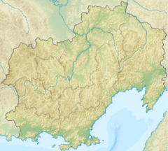
 Mouth location in Magadan Oblast, Russia | |
| Location | |
| Country | Magadan Oblast, Russia |
| Physical characteristics | |
| Source | |
| • location | Hal-Urekchen, Kolyma Mountains |
| • coordinates | 61°41′36″N 155°26′48″E |
| Mouth | Kolyma |
• coordinates | 63°59′13″N 154°14′40″E |
• elevation | 126 m (413 ft) |
| Length | 400 km (250 mi) |
| Basin size | 17,600 km2 (6,800 sq mi) |
| Basin features | |
| Progression | Kolyma→ East Siberian Sea |
The river freezes in October and stays frozen until the end of May.[2] Graylings, longnose suckers, pikes and whitefish are common in the Balygychan waters.[3]
Course
The river has its source in the Hal-Urekchen, at the confluence of the Left Balygychan and Right Balygychan rivers of the Kolyma Mountains. It flows roughly northwards along the western flank of the Omsukchan Range. In its middle course there is the abandoned town of Verkhny Balygychan ("Upper Balygychan"). North of the town the Balygychan flows along a marshy intermontane basin where the river widens, meanders and divides in arms. Finally it joins the right bank of the Kolyma 1,353 km (841 mi) from its mouth.[4][2]
The main tributaries of the Balygychan are the Kyrchan and the Dzhagyn, both joining it from the right. The town of Balygychan lies on the right bank of the Kolyma, just a little upstream from the confluence.[5] There are more than 300 lakes in the basin of the river. It is about 400 km (250 mi) long from the source of the Left Balygychan to the confluence with the Kolyma.[3]
 |
See also
References
- Russian State Water Register - Balygychan
- Балыгычан Great Soviet Encyclopedia in 30 vols. / Ch. ed. A.M. Prokhorov - 3rd ed. - M, 1969-1978. (in Russian)
- Water - Balygychan (in Russian)
- Google Earth
- 1,000,000 scale Operational Navigation Chart; Sheet D-8
External links
- Water (in Russian)
- Kolyma - Modern Guidebook to Magadan Oblast Archived 2018-07-23 at the Wayback Machine
На других языках
[de] Balygytschan
Der Balygytschan (russisch Балыгычан) ist ein rechter Nebenfluss der Kolyma in Sibirien (Russland, Asien).- [en] Balygychan
[es] Río Balygychan
El Balygychán (en ruso: Балыгычан) es un río del óblast de Magadán, en el Extremo Oriente ruso. Tiene una longitud de 352 kilómetros (400 km incluyendo el Levy Balygychán), con una cuenca de drenaje de 17.600 kilómetros cuadrados.[1][it] Balygyčan (fiume)
Il Balygyčan (in russo: Балыгычан?) è un fiume della Russia siberiana orientale, affluente di destra della Kolyma. Scorre nei rajon Omsukčanskij e Srednekanskij dell'Oblast' di Magadan.[ru] Балыгычан
Балыгычан — река на Дальнем Востоке России, в Магаданской области, правый приток Колымы.Другой контент может иметь иную лицензию. Перед использованием материалов сайта WikiSort.org внимательно изучите правила лицензирования конкретных элементов наполнения сайта.
WikiSort.org - проект по пересортировке и дополнению контента Википедии