geo.wikisort.org - River
The Alzou is a short river in the Lot département, southern France, a right tributary of the Ouysse. It is 31.4 km (19.5 mi) long.[1] It flows through the towns Gramat and Rocamadour, and joins the Ouysse, itself a left tributary of the Dordogne, downstream of Rocamadour. The valleys of both the Alzou and the Ouysse are deep limestone canyons.

| Alzou | |
|---|---|
 The GR 65 hiking path winds its way alongside the Alzou. | |
 | |
| Location | |
| Country | France |
| Physical characteristics | |
| Mouth | |
• location | Ouysse |
• coordinates | 44°47′57″N 1°33′36″E |
| Length | 31 km (19 mi) |
| Basin features | |
| Progression | Ouysse→ Dordogne→ Gironde estuary→ Atlantic Ocean |
The river once powered the watermill moulin du Saut, whose ruins can be visited on foot.
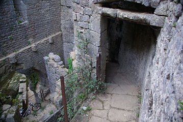 Inside the moulin du Saut
 An outbuilding of the moulin du Saut
 View over the Alzou valley


References
| Wikimedia Commons has media related to Alzou (Ouysse). |
This Lot geographical article is a stub. You can help Wikipedia by expanding it. |
На других языках
[de] Alzou (Ouysse)
Der Alzou ist ein nur etwa 31 km langer Fluss im Département Lot in der Region Okzitanien in Frankreich.- [en] Alzou (Ouysse)
[it] Alzou (Ouisse)
L'Alzou è un fiume francese che nasce dal Massiccio centrale nel dipartimento del Lot nella Occitania; è un affluente dell'Ouysse, quindi un subaffluente della Dordogna.Текст в блоке "Читать" взят с сайта "Википедия" и доступен по лицензии Creative Commons Attribution-ShareAlike; в отдельных случаях могут действовать дополнительные условия.
Другой контент может иметь иную лицензию. Перед использованием материалов сайта WikiSort.org внимательно изучите правила лицензирования конкретных элементов наполнения сайта.
Другой контент может иметь иную лицензию. Перед использованием материалов сайта WikiSort.org внимательно изучите правила лицензирования конкретных элементов наполнения сайта.
2019-2026
WikiSort.org - проект по пересортировке и дополнению контента Википедии
WikiSort.org - проект по пересортировке и дополнению контента Википедии