geo.wikisort.org - River
The Allegheny River (/ˌæləˈɡeɪni/ AL-ə-GAE-nee) is a 325-mile (523 km) long headwater stream of the Ohio River in western Pennsylvania and New York. The Allegheny River runs from its headwaters just below the middle of Pennsylvania's northern border northwesterly into New York then in a zigzag southwesterly across the border and through Western Pennsylvania to join the Monongahela River at the Forks of the Ohio on the "Point" of Point State Park in Downtown Pittsburgh, Pennsylvania. The Allegheny River is, by volume, the main headstream of both the Ohio and Mississippi Rivers. Historically, the Allegheny was considered to be the upper Ohio River by both Native Americans and European settlers.
| Allegheny River | |
|---|---|
 The Allegheny River, looking upstream at Freeport, Pennsylvania | |
| Location | |
| Country | United States |
| State | Pennsylvania, New York |
| Physical characteristics | |
| Source | |
| • location | Allegany Township, Potter County, Pennsylvania, near Coudersport, Pennsylvania at the corner of Ben Green and Cobb Hill Rd |
| • coordinates | 41.8728449°N 77.874998°W[1] |
| • elevation | 2,450 feet (750 m)[2] |
| Mouth | |
• location | Ohio River at Pittsburgh, Pennsylvania |
• coordinates | 40.4434025°N 80.0150536°W[1] |
• elevation | 712 feet (217 m)[1] |
| Length | 325 miles (523 km) |
| Basin size | 11,580 square miles (30,000 km2) |
| Discharge | |
| • average | 19,750 cu ft/s (559 m3/s) at the village of Natrona, PA (river mile 24.3)[3] |
| Basin features | |
| Progression | Allegheny River → Ohio River → Mississippi River → Gulf of Mexico |
| Tributaries | |
| • left | Tionesta Creek, Clarion River, Redbank Creek, Mahoning Creek, Crooked Creek, Kiskiminetas River, Buffalo Creek, Chartiers Run |
| • right | Conewango Creek, Brokenstraw Creek, Oil Creek, French Creek, Bull Creek, Deer Creek, Squaw Run, Pine Creek, Girtys Run, Pucketa Creek |
National Wild and Scenic River | |
| Type | Recreational |
| Designated | April 20, 1992 |
The shallow river has been made navigable upstream from Pittsburgh to East Brady by a series of locks and dams constructed in the early 20th century. A 24-mile long portion of the upper river in Warren and McKean counties of Pennsylvania and Cattaraugus County in New York is the Allegheny Reservoir, created by the erection of the Kinzua Dam in 1965 for flood control.
The name of the river comes from one of a number of Delaware/Unami phrases which are homophones of the English name, with varying translations.
Etymology

The name Allegheny probably comes from Lenape welhik hane[4][5] or oolikhanna, which means 'best flowing river of the hills' or 'beautiful stream'.[6] There is a Lenape legend of a tribe called "Allegewi" who used to live along the river.[7] Hernando de Soto in 1540 and others such as Henry Schoolcraft in subsequent years report the "Allegewi" were the Cherokees.[8]
The following account of the origin of the name Allegheny was given in 1780 by Moravian missionary David Zeisberger: "All this land and region, stretching as far as the creeks and waters that flow into the Alleghene the Delawares called Alligewinenk, which means 'a land into which they came from distant parts'. The river itself, however, is called Alligewi Sipo. The whites have made Alleghene out of this, the Six Nations calling the river the Ohio."[9]
Indians, including the Lenni Lenape and Iroquois, considered the Allegheny and Ohio rivers as the same, as is suggested by a New York State road sign on Interstate 86 that refers to the Allegheny River also as Ohiːyo'.[7] The Geographic Names Information System lists O-hee-yo and O-hi-o as variant names.[10] The river is called Ohi:'i:o` (river beautiful) in the Seneca language.[11] In New York, areas around the river are often named with the alternate spelling Allegany in reference to the river; for example, the Village of Allegany and Allegany State Park. Port Allegany, located along the river in Pennsylvania near the border with New York, also follows this pattern.
Course

The Allegheny River rises in north central Pennsylvania, on Cobb Hill in Allegany Township in north central Potter County,[1][2] 8 miles (16 km) south of the New York–Pennsylvania border and a few miles northwest of the eastern triple divide. The stream flows south and passes under Pennsylvania Route 49 11 miles northeast of Coudersport where a historical marker that declares the start of the river is located. Cobb Hill is about a mile north. The stream flows southwest paralleling Route 49 to Coudersport.[2] It continues west to Port Allegany then turns north into western New York,[12] looping westward across southern Cattaraugus County for approximately 30 miles (48 km), past Portville, Olean, Allegany and Salamanca and flowing through Seneca Indian Nation lands close to the northern boundary of Allegany State Park before re-entering northwestern Pennsylvania within the Allegheny Reservoir just east of the Warren-McKean county line, approx. 10 miles (32 km) northeast of Warren.[13]
It flows in a broad zigzag course generally southwest across Western Pennsylvania; first flowing southwest past Warren, Tidioute, Tionesta, Oil City, and Franklin, forming much of the northwestern boundary of Allegheny National Forest. South of Franklin it turns southeast across Clarion County in a meandering course, then turns again southwest across Armstrong County, flowing past Kittanning, Ford City, Clinton, and Freeport.[14][15][16]

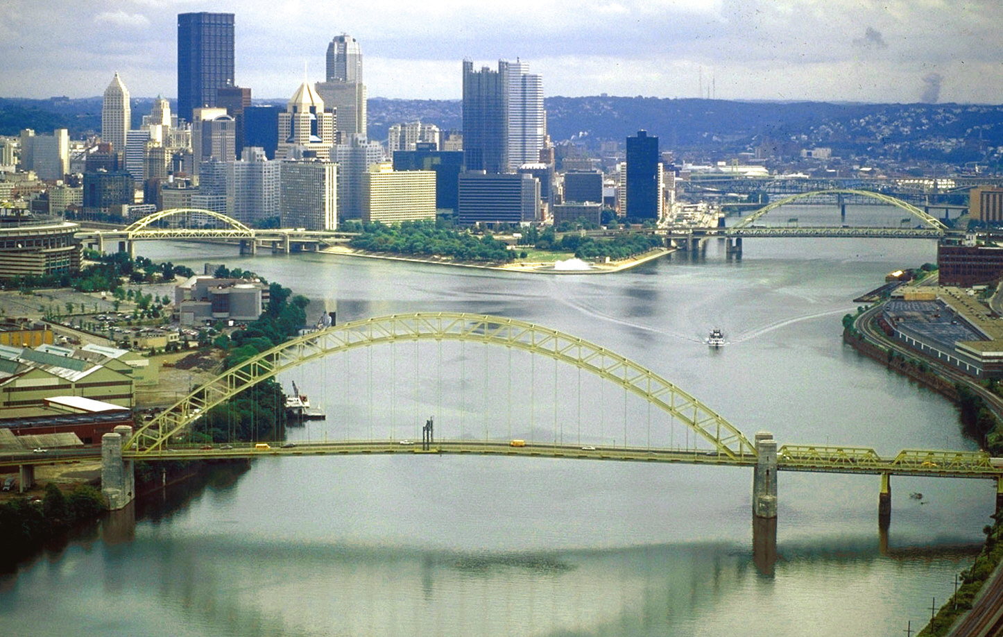
The river enters both Allegheny and Westmoreland counties, the Pittsburgh suburbs, and the City of Pittsburgh from the northeast. It passes the North Side, downtown Pittsburgh, and Point State Park. The Allegheny joins with the Monongahela River at the "Point" in downtown Pittsburgh to form the Ohio River.[17]
Hydrography


The river is approximately 325 miles (523 km) long, running through the U.S. states of New York and Pennsylvania.[10] It drains a rural dissected plateau of 11,580 square miles (30,000 km2) in the northern Allegheny Plateau, providing the northeasternmost drainage in the watershed of the Mississippi River. Its tributaries reach to within 8 miles (13 km) of Lake Erie in southwestern New York.
Water from the Allegheny River eventually flows into the Gulf of Mexico via the Ohio and Mississippi rivers.
The Allegheny Valley has been one of the most productive areas of fossil fuel extraction in United States history, with its extensive deposits of coal, petroleum, and natural gas.
Tributaries
In its upper reaches, the Allegheny River is joined from the south by Potato Creek 1.7 miles (2.7 km) downstream of Coryville, Pennsylvania and from the north by Olean Creek at Olean, New York. Tunungwant "Tuna" Creek joins the river from the south in Carrollton, New York (flowing north from Bradford, Pennsylvania); the Great Valley Creek and Little Valley Creek join the river from the north at Salamanca, New York before becoming the Allegheny Reservoir.
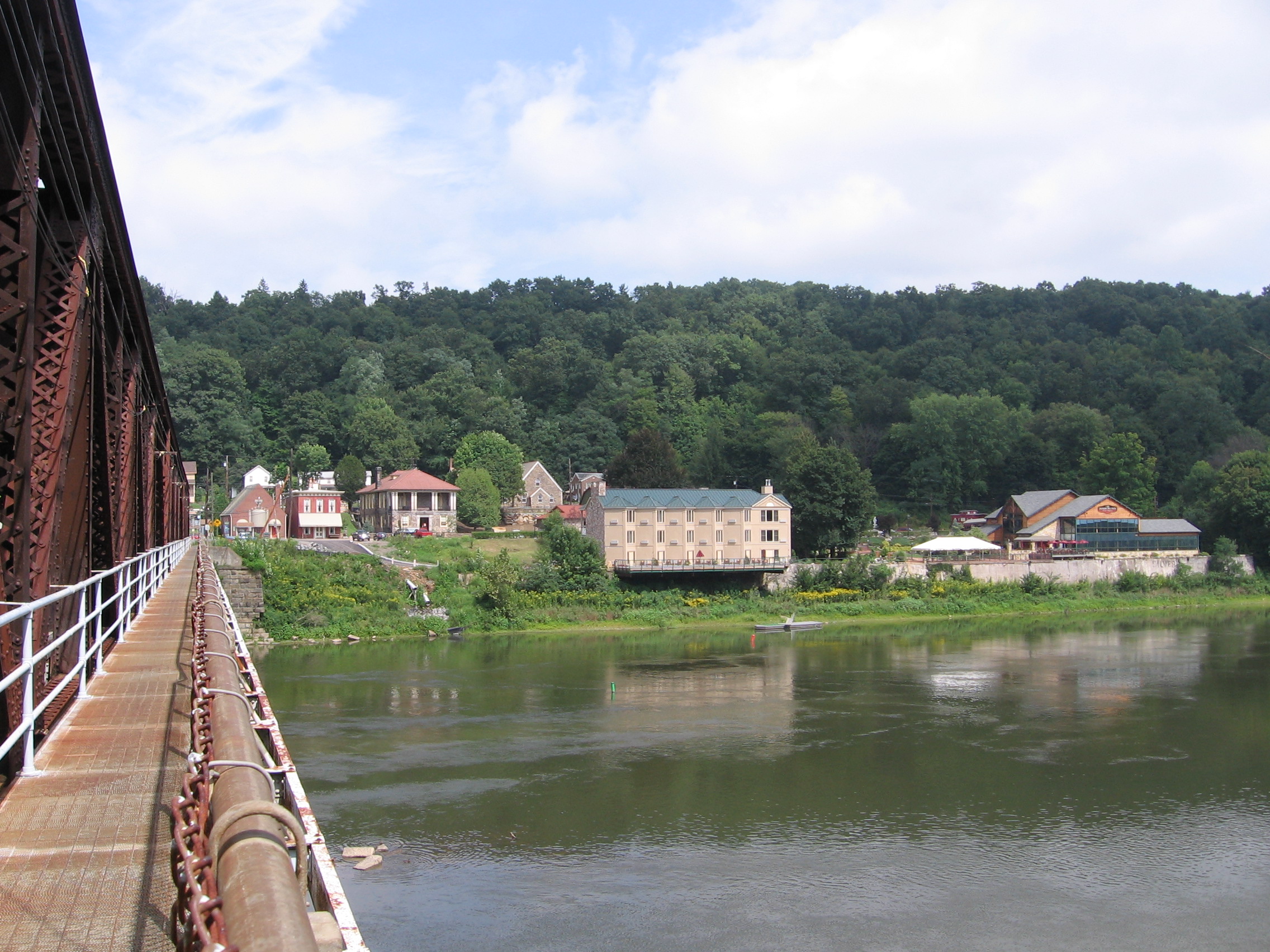
After re-entering Pennsylvania, the river is joined from the east by Kinzua Creek 10 miles (16 km) upstream of Warren; from the north by Conewango Creek at Warren; from the west by Brokenstraw Creek; from the east by East Hickory Creek at East Hickory; from the east by Tionesta Creek at Tionesta; from the north by Oil Creek at Oil City; from the west by French Creek at Franklin; from the east by the Clarion River, a principal tributary, at Parker; from the east by Crooked Creek southeast of Kittanning; and from the east by the Kiskiminetas River, another principal tributary, at Schenley. Buffalo Creek enters at Freeport, Chartiers Run enters at Lower Burrell, Bull Creek enters at Tarentum, Pucketa Creek enters near New Kensington, Riddle Run enters at Springdale, and Girtys Run enters at Millvale. Many additional streams enter or join with the Allegheny River along its course.
Locks, dams and bridges
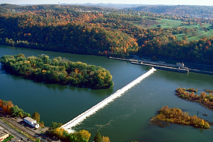
Several locks were built in the early 20th century to make the Allegheny River navigable for 72 miles upstream from Pittsburgh to East Brady.
The Allegheny River has eight locks and fixed-crest dams[18] numbered two through nine: Allegheny River Lock and Dam No. 2, 3, 4, 5, 6, 7, 8, 9 which form corresponding reservoirs.
The river is also impounded by the Kinzua Dam in northwestern Pennsylvania, resulting in the Allegheny Reservoir also known as Kinzua Lake and Lake Perfidy among the Seneca. The Seneca Pumped Storage Generating Station is associated with Kinzua Dam.
Numerous bridges and tunnels span the river throughout its course. The Allegheny River Tunnel, utilized by Pittsburgh Light Rail, went into service in 2012.
History
In the latter half of the 17th century, control of the river valley passed back-and-forth between Algonquian-speaking Shawnee and the Iroquois. By the time of the arrival of the French in the early 18th century, the Shawnee were once again in control and formed an alliance with the French against the incursion of British settlement across the Allegheny Mountains. The conflict over the expansion of British settlement into the Allegheny Valley and the surrounding Ohio Country was a primary cause of the French and Indian War in the 1750s.[19] During the war, the village of Kittanning – the principal Shawnee settlement on the river – was completely destroyed by British reprisal raids from Central Pennsylvania.
Nevertheless, the British, after gaining control of the area in the 1763 Treaty of Paris, kept the area closed to white settlement, in part to repair and maintain relations with the Native Americans. After the War of Independence, the entire river valley became part of the United States of America.
During the 19th century, the river became a principal means of navigation in the upper Ohio valley, especially for the transport of coal. Although the building of the railroads lessened the importance of the river somewhat, the lower river (navigable as far as East Brady, Pennsylvania through locks) has continued to serve as a route of commercial transportation until the present day. In 1859, the first U.S. petroleum was drilled north of the river at Titusville. One of the underlying premises of the Genesee Valley Canal was its connection to the river, opening a trade route from Rochester, New York to the west. The advent of the railroads obviated any interest Pennsylvania might have had in participating to improve navigation on the river. The canal was closed in 1877 and the right-of-way sold to the Genesee Valley Canal Railroad.

In 1965, the completion of the federally sponsored Kinzua Dam for flood-control in northwestern Pennsylvania east of Warren created the long Allegheny Reservoir, known as Lake Perfidy among the Seneca, part of which is included in the Allegheny National Recreation Area. The dam flooded parts of lands deeded "forever" to the Seneca Nation of Indians by the 1794 Treaty of Canandaigua, and lands given to Cornplanter and his descendants. The event was described in the Johnny Cash song "As Long as the Grass Shall Grow" from the 1964 album Bitter Tears: Ballads of the American Indian, which focused on the history of and problems facing Native Americans in the United States.
The construction of the dam and the filling of the Allegheny Reservoir also necessitated the elimination of the small village of Corydon, which was located at the confluence of Willow Creek with the Allegheny River; and the small village of Kinzua, which was located at the confluence of Kinzua Creek with the Allegheny River. All residents of both villages were forced to move.

Many prominent individuals opposed the construction of the dam at that time because of the damage it would do to Seneca lands, including Pennsylvania Congressman John P. Saylor of Johnstown, and Howard Zahniser, executive director of The Wilderness Society and native of Tionesta—a small settlement located along the Allegheny River several miles downstream from Warren. During the campaign for the 1960 United States presidential election, John F. Kennedy assured the Seneca Nation that he would oppose the dam if elected. However, he failed to follow through on his pledge upon becoming president.
In 1992, 86.6 miles (139.4 km) of the Allegheny River was designated Wild and Scenic. This designation comprises three segments of the river located in Warren, Forest, and Venango counties.[20]
In 2008, Katie Spotz became the first person to swim the entire 325 miles (523 km) of the Allegheny River; she was accompanied by safety kayaker, James Hendershott.[21] The team began at the river's source in Warren, Pennsylvania on July 22 and finished at the "Point" in Downtown Pittsburgh on August 21.[22]
Settlements
New York
- Allegany
- Carrollton
- Jimerson Town
- Olean
- Portville
- St. Bonaventure
- Salamanca
- Weston Mills
Pennsylvania
- Applewold
- Arnold
- Aspinwall
- Blawnox
- Brackenridge
- Cheswick
- Coudersport
- Creighton
- East Brady
- East Hickory
- Eldred
- Emlenton
- Etna
- Ford City
- Foxburg
- Franklin
- Freeport
- Harmarville
- Kennerdell
- Kittanning
- Lower Burrell
- Manorville
- Millvale
- Natrona
- New Kensington
- Oakmont
- Oil City
- Parker
- Penn Hills
- Pittsburgh
- Plum
- Port Allegany
- Roulette
- Schenley
- Sharpsburg
- Springdale
- Starbrick
- Tarentum
- Templeton
- Tidioute
- Tionesta
- Verona
- Warren
- West Hickory
- West Kittanning
- Woodland Heights
- Youngsville
See also
- Allegheny Islands State Park
- Allegheny Riverfront Park
- List of rivers of New York
- List of rivers of Pennsylvania
- Pittsburgh Flood of 1936
- Pittsburgh Three Rivers Regatta
References
- "Allegheny River". Geographic Names Information System. United States Geological Survey, United States Department of the Interior.
- Sweden Valley, PA, 7.5 Minute Topographic Quadrangle, USGS, 1969 (1972 rev.)
- USGS Data Report 2009 Retrieved June 16, 2018.
- "welhik". Lenape Talking Dictionary. Archived from the original on October 4, 2011. Retrieved December 14, 2011.
- "Heckewelder here does not give the strict meaning of hanne. The word in common use among Algonkin [i.e., Algonquian] tribes for river is sipu, and this includes the idea of 'a stream of flowing water'. But in the mountainous parts of Pennsylvania, Maryland, and Virginia sipu did not sufficiently convey the idea of a rapid stream, roaring down mountain gorges, and hanne takes its place to designate not a mere sipu, or flowing river, but a rapid mountain stream." Russell, Erret (1885). "Indian Geographical Names". Magazine of Western History. 2 (1): 53–59.
- Trumbull, J. Hammond (1870). The Composition of Indian Geographical Names. Hartford, Conn. pp. 13–14.
- Stewart, George R. (1967). Names on the Land. Boston, Massachusetts: Houghton Mifflin Company. p. 8. ISBN 0-938530-02-X.
- Hodge, Frederick Webb, ed. (1907). Handbook of American Indians north of Mexico. Washington: Government Printing Office. pp. 245-249.
- Zeisberger, David (1999). David Zeisberger's History of the Northern American Indians in 18th Century Ohio, New York and Pennsylvania. Wennawoods Publishing. p. 33. ISBN 1-889037-17-6.
- "Allegheny River". Geographic Names Information System. United States Geological Survey, United States Department of the Interior. Retrieved 2010-05-13.
- "Glossary of Seneca Words". Internet Sacred Text Archive.
- Bradford, PA, 1:100,000 Scale Topographic Map, USGS, 1980
- Olean, NY, 1:100,000 Scale Topographic Map, USGS, 1986
- Warren, PA, 1:100,000 Scale Topographic Map, USGS, 1983
- Oil City, PA, 1:100,000 Scale Topographic Map, USGS, 1983
- Indiana, PA, 1:100,000 Scale Topographic Map, USGS, 1983
- Pittsburg East and Pittsburg West 1:100,000 Scale Topographic Maps, USGS, 1986
- "Know the Rivers!" (PDF). fishandboat.com.
All dams on the Allegheny River are Fixed Crest
- MacCorkle, William Alexander. "The historical and other relations of Pittsburgh and the Virginias". Historic Pittsburgh General Text Collection. University of Pittsburgh. Retrieved 12 September 2013.
- Allegheny Wild and Scenic River – Allegheny National Forest. Retrieved June 16, 2018.
- Shuster, Patrick; Garrone, Francine (2008-08-18). "Ohio woman swimming length of Allegheny River". Pittsburgh Tribune-Review. Tribune-Review Publishing Company. Retrieved June 16, 2018.
- Nephin, Dan (August 22, 2008). "Ohio swimmer completes 325-mile swim of Allegheny". Pittsburgh Tribune-Review. Tribune-Review Publishing Company. Retrieved June 16, 2018.
Further reading
- Schafer, Jim; Mike Sajna (1992). The Allegheny River: Watershed of the Nation. University Park, Pennsylvania, US: The Pennsylvania State University Press. ISBN 978-0-271-00836-3.
External links
Authority control | |
|---|---|
| General |
|
| National libraries | |
| Other | |
На других языках
[de] Allegheny River
Der Allegheny River (auch Alleghany River[2], O-hee-yo[3] oder O-hi-o[3]) ist der rechte Quellfluss des Ohio River im Osten der USA.- [en] Allegheny River
[es] Río Allegheny
El río Allegheny es un río del Noreste de Estados Unidos, el principal afluente del río Ohio. Tiene una longitud de 523 km y drena una cuenca de 30.000 km². Discurre por los estados de Pensilvania y Nueva York.[it] Allegheny (fiume)
L'Allegheny (talvolta anche Allegany, in particolare nello Stato di New York) è localizzato nel nord-est degli Stati Uniti d'America. È il principale dei due fiumi, l'altro è il fiume Monongahela, che a Point State Park nel centro di Pittsburgh dà forma al fiume Ohio. Scorre per una lunghezza di 523 km attraverso gli Stati di New York e Pennsylvania. Il suo bacino idrografico copre una superficie di 29.992 chilometri quadrati. Le fonti di alcuni dei suoi principali affluenti si trovano solo ad una decina di chilometri dal Lago Erie nel sud-ovest dello Stato di New York. La valle fluviale è una dei principali centri di estrazione mineraria degli Stati Uniti, in particolar modo per carbone, petrolio e gas naturale.[ru] Аллегейни (река)
Аллеге́йни[1][2] (Аллегани[3]; англ. Allegheny River) — река в Северной Америке, исток реки Огайо. Длина реки — 516 км, площадь бассейна — 30 300 км²[4]. Средний расход воды — 559 м³/с[5].Другой контент может иметь иную лицензию. Перед использованием материалов сайта WikiSort.org внимательно изучите правила лицензирования конкретных элементов наполнения сайта.
WikiSort.org - проект по пересортировке и дополнению контента Википедии