geo.wikisort.org - River
The Alazeya (Russian: Алазея; Yakut: Алаһыай, romanized: Alahıay) is a river in the northeastern part of Yakutia, Russia which flows into the Arctic between the basins of the larger Indigirka to the west and the Kolyma to the east.
| Alazeya Алазея / Алаһыай | |
|---|---|
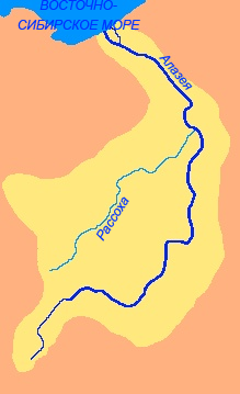
 Location of the Alazeya in Far-East Siberia. | |
 Mouth location in Yakutia, Russia | |
| Location | |
| Country | Russia |
| Location | Yakutia |
| Physical characteristics | |
| Source | |
| • location | Alazeya Plateau |
| • elevation | 116 m (381 ft) |
| Mouth | |
• location | East Siberian Sea |
• coordinates | 70°51′42″N 153°40′46″E |
• elevation | 0 m (0 ft) |
| Length | 1,590 km (990 mi) (total) |
| Basin size | 64,700 km2 (25,000 sq mi) |
| Discharge | |
| • average | 320 m3/s (11,000 cu ft/s) |
Mount Kisilyakh-Tas is a notable kigilyakh site on the right bank of the Alazeya River at 69°42′N 155°0′E.[1]
Geography
The river is 1,590 kilometres (990 mi) long. The area of its basin is 64,700 square kilometres (25,000 sq mi).[2] The Alazeya is formed at the confluence of the Nelkan and Kadylchan rivers in the slopes of the Alazeya Plateau. It crosses roughly northwards through the tundra meandering among the flat, marshy areas of the Kolyma Lowland, part of the greater East Siberian Lowland. Finally the Alazeya drains into the Kolyma Bay of the East Siberian Sea, close to Logashkino. The river freezes in late September through early October and stays icebound until late May through early June. There are more than 24,000 lakes in its basin.[3][4][5][6]
Tributaries
The biggest tributaries of the Alazeya are the 790 km (490 mi) long Rassokha and 131 km (81 mi) long Buor-Yuryakh from the left, as well as the 168 km (104 mi) long Sloboda River and the 244 km (152 mi) long Buor-Yuryakh from the right.[2]
 |
History
Dmitrii Zyryan was the first Russian to reach the Alazeya in 1641,[7] but did not found a permanent settlement.
See also
References
- Types of weathering
- Russian State Water Register - Alazeya River
- Google Earth
- Алазея in the Great Soviet Encyclopedia. (in Russian)
- "R-55_56 Topographic Chart (in Russian)". Retrieved 25 May 2022.
- "Q-55_56 Topographic Chart (in Russian)". Retrieved 25 May 2022.
- Lantzeff, George V., and Richard A. Pierce (1973). Eastward to Empire: Exploration and Conquest on the Russian Open Frontier, to 1750. Montreal: McGill-Queen's University Press.
This Sakha Republic location article is a stub. You can help Wikipedia by expanding it. |
This article related to a river in Russia is a stub. You can help Wikipedia by expanding it. |
На других языках
[de] Alaseja
Die Alaseja (russisch Алазея) ist ein 1520 km[1] langer Fluss bzw. Strom des Kolyma-Tieflands im Osten Sibiriens und Nordosten Russlands (Asien).- [en] Alazeya
[es] Río Alazeya
El río Alazeya (también transcrito como Alazeja) (en ruso: Алазея) es un largo río ruso localizado en la Siberia asiática, que desemboca en el mar de Siberia Oriental. Tiene una longitud de 1.590 km y drena una gran cuenca de 64.700 km² (similar a países como Sri Lanka, Lituania y Letonia).[it] Alazeja
La Alazeja (anche traslitterata come Alazeya) è un fiume della Russia nordorientale, interamente compreso nel territorio della Repubblica Autonoma della Sacha-Jacuzia.[ru] Алазея
Алазе́я (якут. Алаһыай) — большая река в России, протекает на северо-востоке Якутии. К востоку от Индигирки впадает в Восточно-Сибирское море.Другой контент может иметь иную лицензию. Перед использованием материалов сайта WikiSort.org внимательно изучите правила лицензирования конкретных элементов наполнения сайта.
WikiSort.org - проект по пересортировке и дополнению контента Википедии