geo.wikisort.org - River
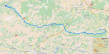
The Ailette (French pronunciation: [ɛlɛt]) is a 59.5 km (37.0 mi) long river in the Aisne department in eastern France.[1] Its source is at Sainte-Croix. It flows generally west-northwest. It is a left tributary of the Oise into which it flows between Manicamp and Quierzy, 30 km (19 mi) northeast of Compiègne.
| Ailette | |
|---|---|
 Center Parcs, Lac d'Ailette area, Chamouile, Aisne, France | |
 | |
| Location | |
| Country | France |
| Physical characteristics | |
| Source | |
| • location | Sainte-Croix |
| • coordinates | 49°29′11″N 03°46′37″E |
| • elevation | 110 m (360 ft) |
| Mouth | |
• location | Oise |
• coordinates | 49°34′40″N 03°09′41″E |
• elevation | 40 m (130 ft) |
| Length | 59.5 km (37.0 mi) |
| Basin size | 540 km2 (210 sq mi) |
| Discharge | |
| • average | 3 m3/s (110 cu ft/s) |
| Basin features | |
| Progression | Oise→ Seine→ English Channel |
On most of its course, it shares its valley with the Canal de l'Oise à l'Aisne.
Communes along its course
This list is ordered from source to mouth:
- Aisne: Sainte-Croix, Corbeny, Craonne, Bouconville-Vauclair, Chermizy-Ailles, Neuville-sur-Ailette, Cerny-en-Laonnois, Chamouille, Pancy-Courtecon, Colligis-Crandelain, Trucy, Chevregny, Monampteuil, Filain, Pargny-Filain, Urcel, Chavignon, Royaucourt-et-Chailvet, Chaillevois, Merlieux-et-Fouquerolles, Vaudesson, Pinon, Lizy, Anizy-le-Château, Vauxaillon, Landricourt, Leuilly-sous-Coucy, Jumencourt, Crécy-au-Mont, Coucy-le-Château-Auffrique, Pont-Saint-Mard, Guny, Champs, Trosly-Loire, Saint-Paul-aux-Bois, Pierremande, Bichancourt, Manicamp, Quierzy
References
This Aisne geographical article is a stub. You can help Wikipedia by expanding it. |
На других языках
[de] Ailette
Die Ailette ist ein Fluss in Frankreich, der im Département Aisne in der Region Hauts-de-France verläuft. Er entspringt im Gemeindegebiet von Sainte-Croix und entwässert generell in Richtung West bis Nordwest. Bei Monampteuil erreicht die Ailette den Canal de l’Oise à l’Aisne, dotiert diesen im Bassin von Monampteuil mit Wasser und verläuft danach in geringem Abstand nördlich des Kanals. Im Mündungsabschnitt schwenkt der Fluss nach Südwest, unterquert den Kanal und mündet nach insgesamt rund 59[2] Kilometern unterhalb von Manicamp als linker Nebenfluss in die Oise.- [en] Ailette (river)
[es] Río Ailette
El río Ailette es un corto río de Francia, un afluente por la izquierda del río Oise. Discurre enteramente por el departamento de Aisne. Sus fuentes, situadas cerca de Craonne, se encuentran a 200 m sobre el nivel del mar. Desemboca en el Oise en Manicamp.[it] Ailette
L'Ailette, detto anche La Lette, è un piccolo fiume francese del dipartimento dell'Aisne, nella regione Alta Francia, affluente alla riva sinistra dell'Oise.Текст в блоке "Читать" взят с сайта "Википедия" и доступен по лицензии Creative Commons Attribution-ShareAlike; в отдельных случаях могут действовать дополнительные условия.
Другой контент может иметь иную лицензию. Перед использованием материалов сайта WikiSort.org внимательно изучите правила лицензирования конкретных элементов наполнения сайта.
Другой контент может иметь иную лицензию. Перед использованием материалов сайта WikiSort.org внимательно изучите правила лицензирования конкретных элементов наполнения сайта.
2019-2026
WikiSort.org - проект по пересортировке и дополнению контента Википедии
WikiSort.org - проект по пересортировке и дополнению контента Википедии