geo.wikisort.org - Fluss
Der South Fork Eel River ist der bedeutendste linke Nebenfluss des Eel River im Nordwesten des US-Bundesstaates Kalifornien. Der 169 km lange Fluss entwässert ein Areal von 1784 km².
| South Fork Eel River | ||
 Flusslauf im Einzugsgebiet des Eel River | ||
| Daten | ||
| Gewässerkennzahl | US: 253918 | |
| Lage | Kalifornien (USA) | |
| Flusssystem | Eel River | |
| Abfluss über | Eel River → Pazifischer Ozean | |
| Quelle | im Mendocino County 39° 36′ 46″ N, 123° 29′ 34″ W | |
| Mündung | nahe Dyerville in den Eel River 40° 21′ 21″ N, 123° 55′ 10″ W | |
| Mündungshöhe | 33 m[1]
| |
| Länge | 169 km[1] | |
| Einzugsgebiet | 1784 km²[2] | |
| Abfluss am Pegel Miranda[3] AEo: 1390 km² |
MQ 1940/2016 Mq 1940/2016 |
51 m³/s 36,7 l/(s km²) |
| Gemeinden | Benbow, Garberville, Leggett, Miranda, Myers Flat, Phillipsville, Redway, Weott | |
| National Wild and Scenic River | ||
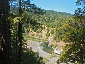
 South Fork Eel River in der Standish-Hickey SRA | ||
 South Fork Eel River nahe Benbow | ||
Der South Fork Eel River entspringt 9,3 km südlich von Laytonville im Mendocino County.[1] Er strömt in überwiegend nördlicher Richtung durch das Kalifornische Küstengebirge. Der U.S. Highway 101 verläuft entlang dem Fluss. Der South Fork Eel River mündet schließlich bei Dyerville im Humboldt County in den Eel River.
Am 19. Januar 1981 wurden insgesamt 640 km im Flusssystem des Eel River als National Wild and Scenic River ausgezeichnet.[4] Der Flussabschnitt des South Fork Eel River von seiner Mündung bis zur Einmündung des Four Creek wurde dabei unter Schutz gestellt.[4] Im South Fork Eel River kommen verschiedene Lachse und Salmonidenarten vor.[4]
Nahe der Quelle bei Branscomb liegt die Admiral Stanley State Recreation Area. Ein Abschnitt der State Route 254 entlang dem Flusslauf ist als Avenue of the Giants ein so genannter scenic highway. Am Oberlauf bei Leggett befindet sich die Standish-Hickey State Recreation Area, weiter abstrom der Richardson Grove State Park. Unweit der Mündung liegt der Humboldt Redwood State Park am Ufer des South Fork Eel River.
Im Ort Benbow am Mittellauf des South Fork Eel River wurde 1931 der Staudamm Benbow Dam zur Gewinnung von Elektrizität aus Wasserkraft errichtet. Dadurch entstand der 123 Hektar große See Benbow Lake. Ende 2016 wurde der Staudamm wieder abgerissen. Somit ist der Fluss wieder auf der gesamten Strecke für Wanderfische zugänglich.[5][6]
Weblinks
Einzelnachweise
- South Fork Eel River im Geographic Names Information System des United States Geological Survey
- South Fork Eel River Watershed Studies (Humboldt and Mendocino Counties). Calif. Dept. of Fish and Wildlife. Abgerufen am 12. August 2017.
- USGS 11476500 SF EEL R NR MIRANDA CA
- National Wild and Scenic Rivers System: Eel River, California
- Benbow Dam demolition on schedule. Times Standard. 5. September 2016.
- Benbow Dam demolition began on Aug. 1. Redwood Times. 1. August 2016.
На других языках
- [de] South Fork Eel River (Kalifornien)
[en] South Fork Eel River
The South Fork Eel River is the largest tributary of the Eel River in north-central California in the United States. The river flows 105 miles (169 km) north from Laytonville to Dyerville/Founders' Grove where it joins the Eel River. The South Fork drains a long and narrow portion of the Coast Range of California in parts of Mendocino and Humboldt counties. U.S. Route 101 follows the river for much of its length.[3][it] South Fork Eel
Il South Fork Eel River è il maggiore affluente dell'Eel River, nella California centro-settentrionale, negli USA. Il fiume è lungo 169 km, nasce sulle Iron Mountain nell'ovest della contea di Mendocino e termina il suo corso, immettendosi nell'Eel River, nei pressi della cittadina di Dyerville. Il bacino del South Fork drena una parte lunga e stretta della Catena Costiera della California, tra le contee di Mendocino e quella di Humboldt.Другой контент может иметь иную лицензию. Перед использованием материалов сайта WikiSort.org внимательно изучите правила лицензирования конкретных элементов наполнения сайта.
WikiSort.org - проект по пересортировке и дополнению контента Википедии