geo.wikisort.org - Fluss
Der Foglia ist der nördlichste Fluss der Region Marken in Italien, der seine ersten 9 km[1] in der Toskana verbringt. Seine Gesamtlänge ist 90 km.
| Foglia | ||
 Der Foglia bei Pesaro | ||
| Daten | ||
| Lage | Marken, Italien | |
| Flusssystem | Foglia | |
| Flussgebietseinheit | Appennino Centrale | |
| Quelle | in der Provinz Arezzo in der Toskana, nahe dem Sasso Aguzzo 43° 41′ 43″ N, 12° 14′ 37″ O | |
| Mündung | in Pesaro in die Adria 43° 55′ 25″ N, 12° 54′ 5″ O
| |
| Länge | 90 km | |
| Mittelstädte | Pesaro | |
| Gemeinden | Sestino, Belforte all’Isauro, Piandimeleto, Sassocorvaro, Auditore, Montecalvo in Foglia, Montelabbate | |
Verlauf
Der Fluss entspringt in der Provinz Arezzo in der Toskana, nahe dem Sasso Aguzzo, einem Hügel in der Umgebung der Gemeinden Sestino und Badia Tedalda im toskanischen Apennin. Danach durchfließt er die Gemeinden von Sestino (AR), Belforte all’Isauro (PU), Piandimeleto (PU), Lunano (PU), Sassocorvaro (PU), Auditore (PU), Montecalvo in Foglia (PU), Montelabbate (PU) und Pesaro (PU), von wo aus er in die Adria mündet.
Geschichte
In der Zeit der Picener (bis zum 3. Jahrhundert v. Chr.) war die Foglia die nördliche Grenze ihres Reiches. Zudem diente sie dem Vikariat von Urbino als östliche Grenze.
Namensherkunft
Der lateinische Name des Flusses war Pisaurum, nach dem römischen Namen für die Stadt Pesaro in der Provinz Pesaro und Urbino benannt, die er als letztes größeres Handelszentrum durchquert.
Bilder
 Der Foglia kurz nach der Entstehung bei Sestino am Zusammenfluss mit dem Bornacchio
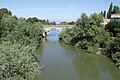 Der Foglia bei Pesaro kurz vor der Mündung in die Adria


Weblinks
Einzelnachweise
На других языках
- [de] Foglia
[en] Foglia
The Foglia is the northernmost river of the Marche region of Italy. In ancient times it was known as Pisaurus,[1] as it debouched into the Adriatic Sea at Pisaurum (modern Pesaro). It was also known as the Isaurus.[2] The source of the river is west of Sestino in the province of Arezzo (which is in the Tuscany region of Italy) in the Umbrian-Marchean Apennines mountains.[3] It flows east through an extension of the province of Pesaro e Urbino and then back into Arezzo before forming the border between Arezzo and Pesaro e Urbino. The river then flows into the province of Pesaro e Urbino past Piandimeleto and curves northeast and flows past Sassocorvaro before curving east again. The river meanders south of Montecalvo in Foglia before curving northeast and flowing near Colbordolo, Saludecio, Sant'Angelo in Lizzola, Montecchio, Montelabbate and Tavullia before entering the Adriatic Sea near Pesaro.[es] Foglia
El río Foglia es un río costero de la vertiente del mar Adriático de Italia, el más septentrional de la región de las Marcas.[it] Foglia (fiume)
Il (o la) Foglia[1] è un fiume che attraversa la provincia di Pesaro e Urbino nelle Marche, giungendo fino a Pesaro, dove sfocia nel mare Adriatico.[ru] Фолья
Фолья (итал. Foglia) — река в центральной Италии. Длина 90 км. Средний расход воды — 7 м³/с.[источник не указан 1958 дней]Другой контент может иметь иную лицензию. Перед использованием материалов сайта WikiSort.org внимательно изучите правила лицензирования конкретных элементов наполнения сайта.
WikiSort.org - проект по пересортировке и дополнению контента Википедии