geo.wikisort.org - Fluss
Die Bann (ir. An Bhanna) ist mit einer Gesamtlänge von 129 km einer der längsten Flüsse in Nordirland.
| Bann | ||
 Die Bann in Coleraine | ||
| Daten | ||
| Lage | Nordirland | |
| Flusssystem | Bann | |
| Flussgebietseinheit | Neagh Bann IRBD | |
| Quelle | als Upper Bann im Distrikt Newry, Mourne and Down östlich Newry 54° 11′ 16″ N, 6° 4′ 53″ W | |
| Mündung | als Lower Bann nordwestlich von Coleraine in den Nordkanal 55° 10′ 12″ N, 6° 46′ 21″ W | |
| Mündungshöhe | 0 m ASL
| |
| Länge | 129 km | |
| Durchflossene Seen | Lough Neagh | |
| Mittelstädte | Portadown | |
| Kleinstädte | Banbridge, Kilrea, Coleraine | |
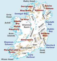
Die Upper Bann entspringt in den Mourne Mountains im Süden Nordirlands und mündet in den Lough Neagh, den größten See des Vereinigten Königreichs.
Die Lower Bann verlässt den See nach Norden, passiert Kilrea und mündet in den Atlantik, kurz nachdem sie die Stadt Coleraine durchflossen hat.
Die wasserrechtliche Aufsicht und Bewirtschaftung hat die zwischenstaatliche irisch-nordirische Behörde Waterways Ireland inne.
Am Ufer des Bann findet sich der Dolmen von Craigs und am Mount Sandel der älteste Beleg für die Besiedlung Irlands.
Weblinks
Commons: Bann – Sammlung von Bildern, Videos und Audiodateien
- www.riverbannireland.com/ Offizielle Website
На других языках
- [de] Bann (Fluss)
[en] River Bann
The River Bann (from Irish: An Bhanna, meaning "the goddess";[1] Ulster-Scots: Bann Wattèr[2]) is one of the longest rivers in Northern Ireland, its length, Upper and Lower Bann combined, being 129 km (80 mi). However, the total length of the River Bann, including its path through the 30 km (19 mi) long Lough Neagh is 159 km (99 mi). Another length of the River Bann given is 90 mi.[3] The river winds its way from the southeast corner of Northern Ireland[4] to the northwest coast,[5] pausing in the middle to widen into Lough Neagh. The River Bann catchment has an area of 5,775 km2.[6] The River Bann has a mean discharge rate of 92 m3/s.[7] According to C. Michael Hogan, the Bann River Valley is a settlement area for some of the first human arrivals in Ireland after the most recent glacial retreat.[8][es] Río Bann
El Bann es el río más largo de Irlanda del Norte. El alto Bann nace en el monte de Mourne y desemboca en el lago Lough, mientras que el bajo Bann discurre en dirección norte desde el lago Neagh al mar, desembocando en Coleraine. La longitud total del río es de 129 kilómetros.[it] Bann (fiume)
Il fiume Bann, in gaelico irlandese An Bhanna, è il più lungo dell'Irlanda del Nord scorrendo dalla sorgente alla foce per circa 129 chilometri. Col suo corso, il Bann attraversa la provincia dall'estremo angolo sud-orientale fino alla costa nord-occidentale e, circa a metà della sua strada, funge da immissario del Lough Neagh, il più vasto lago dell'intera isola irlandese. Il fiume ha giocato un ruolo di vitale importanza per lo sviluppo economico e l'industrializzazione dell'Ulster, specialmente per l'industria del lino. Oggigiorno una delle più importanti attività economiche che hanno sede sul Bann sono le pescherie di salmoni e anguille. An Bhanna è inoltre ritenuta la linea di confine naturale tra l'area orientale e quella occidentale dell'Irlanda del Nord. Queste ultime risultano parecchio dissimili in vari ambiti: prima di tutto a livello economico, essendo la parte ad est del fiume molto più sviluppata, oltre che soggetta a maggiori finanziamenti da parte del governo. Differenze sussistono anche dal punto di vista sociale: a ovest vi è una maggiore concentrazione di repubblicani, nazionalisti e cattolici, mentre a est prevalgono i protestanti e gli unionisti.[ru] Банн (река)
Банн[1][2] (устар. Бэнн[3]; англ. River Bann; ирл. An Bhanna[4]) — крупнейшая река Северной Ирландии; берёт начало в горах Морн, к востоку от Ньюри, протекает через озеро Лох-Ней, впадает в Северный пролив в 7 км ниже Колрейна[1][4][3]. Длина — 129 км[4].Текст в блоке "Читать" взят с сайта "Википедия" и доступен по лицензии Creative Commons Attribution-ShareAlike; в отдельных случаях могут действовать дополнительные условия.
Другой контент может иметь иную лицензию. Перед использованием материалов сайта WikiSort.org внимательно изучите правила лицензирования конкретных элементов наполнения сайта.
Другой контент может иметь иную лицензию. Перед использованием материалов сайта WikiSort.org внимательно изучите правила лицензирования конкретных элементов наполнения сайта.
2019-2026
WikiSort.org - проект по пересортировке и дополнению контента Википедии
WikiSort.org - проект по пересортировке и дополнению контента Википедии