geo.wikisort.org - Bacino
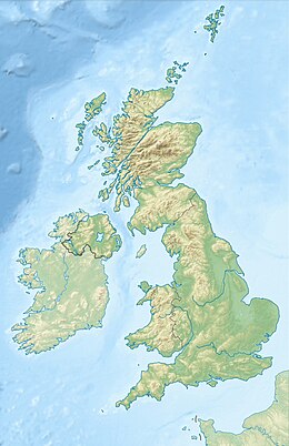
Il Thirlmere è un lago artificiale di 3,25 km² dell'Inghilterra nord-occidentale, situato nel Lake District National Park, nella contea della Cumbria.
| Thirlmere | |
|---|---|
 | |
| Stato | |
| Regione/area/distretto | |
| Contea | Cumbria |
| Coordinate | 54°32′N 3°04′W |
| Altitudine | 178 m s.l.m. |
| Dimensioni | |
| Superficie | 3,25 km² |
| Lunghezza | 6,05 km |
| Larghezza | 0,178 km |
| Profondità massima | 40 m |
| Sviluppo costiero | 15 km |
| Idrografia | |
| Isole | Hawes How Island |
 Thirlmere | |
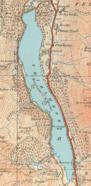 | |
Principali località situate nei pressi del lago sono il villaggio omonimo e il villaggio di Wythburn.[1][2][3][4]
Geografia
Il Thirlmere si trova tra il Lago Derwent (Derwent Water) e l'Ullswater (rispettivamente a sud-est del primo e ad ovest del secondo), a nord del Grasmere ed è situato ai piedi del monte Helvellyn.[2][3]
Il lago ha una lunghezza di 6 km, larghezza massima di 0,78 km e una profondità di 158 piedi.[5]
Nel lago sorge un'isola, Hawes How Island.[6]
Storia
In origine sorgevano nell'area due laghi.[1] Il Thirlmere sorse alla fine del XIX secolo con la costruzione di una diga dell'altezza di 104 piedi da parte della Manchester City Corporation Waterworks nel 1889.[1]
La costruzione della diga cancellò il villaggio di Armboth e gran parte del villaggio di Wythburn (di cui rimase in piedi solo la chiesa).[1] I lavori terminarono nel 1925, quando fu completata la costruzione dell'acquedotto del Thirlmere, che giunse fino a Manchester.[7]
Nel 1908, venne realizzata attorno al lago una foresta di abeti rossi e larici.[1]
Note
- (EN) Thirlmere, su thelakedistrict.org, Visit Cumbria. URL consultato il giugno 2020.
- (EN) Thirlmere, su google.it, Google Maps. URL consultato il 23 giugno 2020.
- (EN) Visit Keswick, su keswick.org, Visit Keswikc. URL consultato il 23 giugno 2020.
- (EN) Wythburn, su visitcumbria.com, Visit Cumbria. URL consultato il giugno 2020.
- (EN) Thirlmere Area Guide, su thelakedistrict.org, The Lake District.org. URL consultato il giugno 2020.
- (EN) Hawes How Island, su getoutside.ordnancesurvey.co.uk, Get Outside Ordnance Survey. URL consultato il giugno 2020.
- (EN) The Hodder and Thirlmere Aqueduct Access Gates, su jdscomponents.co.uk, JDS Components.co.uk. URL consultato il 23 giugno 2020.
Altri progetti
 Wikimedia Commons contiene immagini o altri file su Thirlmere
На других языках
[de] Thirlmere
Der Thirlmere ist ein See im nordenglischen Nationalpark Lake District. Er ist etwa sechs Kilometer lang und 300 Meter breit.[en] Thirlmere
Thirlmere is a reservoir in the Borough of Allerdale in Cumbria and the English Lake District. The Helvellyn ridge lies to the east of Thirlmere. To the west of Thirlmere are a number of fells; for instance, Armboth Fell and Raven Crag both of which give views of the lake and of Helvellyn beyond. It runs roughly south to north and is bordered on the eastern side for much of its length by the A591 road and on the western side by a minor road. It occupies the site of a former natural lake: this had a fordable waist so narrow that it was (and is) sometimes regarded as two lakes. In the 19th century Manchester Corporation constructed a dam at the northern end, raising the water level, flooding the valley bottom, and creating a reservoir to provide the growing industrial city of Manchester with water supplies via the 96 mile-long Thirlmere Aqueduct. The reservoir and the aqueduct still provide water to the Manchester area, but under the Water Act 1973 ownership passed to the North West Water Authority; as a result of subsequent privatisation and amalgamation they (and the catchment area surrounding the reservoir) are now owned and managed by United Utilities, a private water and waste water company.[fr] Thirlmere
Le Thirlmere est un lac de barrage situé en Cumbria dans le Lake District.- [it] Thirlmere
Другой контент может иметь иную лицензию. Перед использованием материалов сайта WikiSort.org внимательно изучите правила лицензирования конкретных элементов наполнения сайта.
WikiSort.org - проект по пересортировке и дополнению контента Википедии