geo.wikisort.org - Bacino
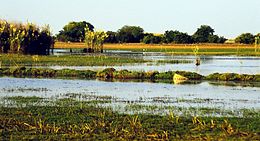
Il lago Bangweulu è un lago d'acqua dolce dello Zambia. Il suo nome significa “il luogo dove l'acqua e il cielo si incontrano”.
| Lago Bangweulu | |
|---|---|
 | |
| Stato | |
| Coordinate | 11°05′S 29°45′E |
| Altitudine | 1.140 m s.l.m. |
| Dimensioni | |
| Superficie | dai 4.000 ai 10.000 km² |
| Lunghezza | 75 km |
| Profondità massima | 10 m |
| Volume | 0,005 km³ |
| Idrografia | |
| Bacino idrografico | 109 469 km² |
| Emissari principali | fiume Luapula |
 | |
Geografia
Il lago è la fonte del fiume Luapula che ne rappresenta anche l'emissario, ed è alimentato da 17 fiumi principali. È situato ad un'altitudine di 1.140 metri sul livello del mare, e misura circa 75 km di larghezza nel punto più ampio. È un lago poco profondo, misurando 4 metri di profondità media e 10 metri di massima. La sua superficie è variabile secondo le stagioni dai 4.000 ai 10.000 km².
Principali fonti del lago e delle paludi delle sue regioni meridionali è il fiume Chambeshi. Le acque di questa regione fanno parte del sistema fluviale del fiume Congo. Il lago è composto da 3 specchi d'acqua tra loro paralleli:
- a nord-ovest il lago Chifunabuli che misura 50 km di lunghezza per 5 km di larghezza ed è separato dal resto del bacino per una striscia di terra sottile (250 metri) chiamata Penisola Lifunge.
- a sud-est il lago Walipupe (30 km di lunghezza per 13 di larghezza).
- al centro il lago Bangweulu che è il lago principale.
Sia a sud che a est del lago si estendono le paludi del Bangweulu che si snodano su una lunghezza di 120 km per 75 km di larghezza. Nelle stagioni delle piogge le paludi possono raggiungere una superficie di 15.000 km².
Altri progetti
 Wikimedia Commons contiene immagini o altri file su lago Bangweulu
Collegamenti esterni
- (EN) Lago Bangweulu / Lago Bangweulu (altra versione), su Enciclopedia Britannica, Encyclopædia Britannica, Inc.
| Controllo di autorità | VIAF (EN) 240093031 · LCCN (EN) sh87006084 · GND (DE) 4608931-7 |
|---|
На других языках
[de] Bangweulusee
Der Bangweulusee (Bantusprache für Großes Wasser, auch Bangweolosee; englisch Lake Bangweulu) ist ein See im Nordosten Sambias. Er liegt an der tiefsten Stelle des Bangweulubassins. Bangweulu heißt Ort, wo das Wasser den Himmel trifft.[en] Lake Bangweulu
Bangweulu — 'where the water sky meets the sky' — is one of the world's great wetland systems, comprising Lake Bangweulu, the Bangweulu Swamps and the Bangweulu Flats or floodplain.[2] Situated in the upper Congo River basin in Zambia, the Bangweulu system covers an almost completely flat area roughly the size of Connecticut or East Anglia, at an elevation of 1,140 m straddling Zambia's Luapula Province and Northern Province. It is crucial to the economy and biodiversity of northern Zambia, and to the birdlife of a much larger region, and faces environmental stress and conservation issues.[3][es] Lago Bangweulu
El lago Bangweulu (a veces erróneamente Bangwelu y castellanizado como Bangüeolo) es un lago de agua dulce ubicado en Zambia. Su nombre significa «lugar donde el agua y el cielo se unen». El lago es la fuente del río Luapula y es alimentado por 17 ríos. Está situada a 1140 m de altitud, tiene aproximadamente 75 km de largo y cubre un área de 9840 km². Su profundidad media es de 4 metros. Su superficie es variable dependiendo de la temporada.[fr] Lac Bangwelo
Le lac Bangwelo[1] est un lac d’eau douce situé en Zambie.- [it] Lago Bangweulu
[ru] Бангвеулу
Бангвеу́лу[1] (англ. Lake Bangweulu) — крупное мелководное озеро в Замбии, точнее, водная система, объединяющая озеро Бангвеулу, болота Бангвеулу и плато или пойму Бангвеулу[2].Другой контент может иметь иную лицензию. Перед использованием материалов сайта WikiSort.org внимательно изучите правила лицензирования конкретных элементов наполнения сайта.
WikiSort.org - проект по пересортировке и дополнению контента Википедии
