geo.wikisort.org - Bacino
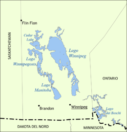
Il Cedar Lake è un lago del Canada, situato nella provincia di Manitoba.
| Cedar Lake | |
|---|---|
| Stato | |
| Provincia | Manitoba |
| Coordinate | 53°22′N 100°00′W |
| Altitudine | 253 m s.l.m. |
| Dimensioni | |
| Superficie | 1.353 km² |
| Lunghezza | 62,5 km |
 Cedar Lake | |
 | |
Ha una superficie di 1.353 km².
Situato ad una altitudine di 253 m s.l.m. Riceve le acque del fiume Saskatchewan. È collegato al Lago Winnipeg tramite la diga di Grand Rapids.
Principali centri lungo le sue coste sono Easterville e Grand Rapids.
Altri progetti
 Wikimedia Commons contiene immagini o altri file su Cedar Lake
На других языках
[de] Cedar Lake (Saskatchewan River)
Der Cedar Lake liegt am Unterlauf des Saskatchewan River, der ihn durchfließt, unmittelbar vor dessen Mündung in den Winnipegsee. Der Wasserspiegel des Cedar Lake wird vom Grand Rapids Dam reguliert. Der See ist beliebt bei Hobbyfischern (bspw. Glasaugenbarsch bzw. Amerikanischer Zander (Sander vitreus)).[en] Cedar Lake (Manitoba)
Cedar Lake is a lake just north of Lake Winnipegosis in Manitoba, Canada. Cedar Lake's water level is controlled by the Grand Rapids dam. The town of Grand Rapids and the First Nations town of Easterville are nearby.[fr] Lac des Cèdres
Le lac des Cèdres, ou lac Cedar (en anglais : Cedar Lake), est une étendue d'eau située dans la province du Manitoba au Canada.- [it] Cedar Lake (Manitoba)
[ru] Сидар (озеро, Канада)
Сидар (англ. Cedar Lake — кедровое озеро) — озеро в провинции Манитоба в Канаде.Текст в блоке "Читать" взят с сайта "Википедия" и доступен по лицензии Creative Commons Attribution-ShareAlike; в отдельных случаях могут действовать дополнительные условия.
Другой контент может иметь иную лицензию. Перед использованием материалов сайта WikiSort.org внимательно изучите правила лицензирования конкретных элементов наполнения сайта.
Другой контент может иметь иную лицензию. Перед использованием материалов сайта WikiSort.org внимательно изучите правила лицензирования конкретных элементов наполнения сайта.
2019-2025
WikiSort.org - проект по пересортировке и дополнению контента Википедии
WikiSort.org - проект по пересортировке и дополнению контента Википедии