geo.wikisort.org - Reservoir
Cedar Lake is a lake just north of Lake Winnipegosis in Manitoba, Canada. Cedar Lake's water level is controlled by the Grand Rapids dam. The town of Grand Rapids and the First Nations town of Easterville are nearby.
| Cedar Lake | |
|---|---|
 NASA image showing Cedar Lake | |
 Cedar Lake | |
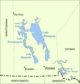 Map with the other Prairie lakes | |
| Location | Division No. 21, North-West Manitoba |
| Coordinates | 53°19′45″N 100°10′08″W |
| Primary inflows | Saskatchewan River |
| Primary outflows | Saskatchewan River |
| Basin countries | Canada |
| Surface area | 1,353 km2 (522 sq mi) |
| Max. depth | 10 m (33 ft) |
| Surface elevation | 253 m (830 ft) |
The lake is known to have excellent examples of prehistoric amber fossil of cretaceous age.[1] This type of amber is called as "Chemawinit", according to an Indian tribe which lives in this area.[citation needed] Another name of this amber is "Cedarit".[2] This amber contains many organic inclusions. To date, these inclusions have not been thoroughly researched.[3]
The lake's main source is the Saskatchewan River, which forms a delta on the northwest side of the lake. The flow of the Saskatchewan River to Lake Winnipeg on the eastern end of Cedar Lake is regulated by the Grand Rapids dam built in 1962 by Manitoba Hydro.[4][5][6]
See also
- Saskatchewan River Delta
- List of lakes of Manitoba
References
- "Saskatchewan River Delta, Manitoba, Canada October 29, 2007". NASA. Retrieved 2014-09-12.
- R.Klebs: Cedarit, ein neues bernsteinähnliches Harz Canadas und sein Vergleich mit anderen fossilen Harzen. - Jahrbuch des königlichen preußischen geologischen Landesamtes. Berlin, 1897.
- George O. Poinar, Jr.: Life in Amber. 350 p., 147 fig., 10 tab., Stanford University Press, Stanford (Cal.) 1992. ISBN 0-8047-2001-0
- "Manitoba Historical Society (Thundering Waters Stilled: The Grand Rapids of the Saskatchewan by Martha McCarthy)". 1988. Retrieved 2014-09-12.
- "Natural Resources Canada-Canadian Geographical Names (Cedar Lake)". Retrieved 2014-08-29.
- "Atlas of Canada Toporama". Retrieved 2014-08-29.
List of lakes of Canada (by province or territory) | |
|---|---|
| Provinces |
|
| Territories | |
| |
На других языках
[de] Cedar Lake (Saskatchewan River)
Der Cedar Lake liegt am Unterlauf des Saskatchewan River, der ihn durchfließt, unmittelbar vor dessen Mündung in den Winnipegsee. Der Wasserspiegel des Cedar Lake wird vom Grand Rapids Dam reguliert. Der See ist beliebt bei Hobbyfischern (bspw. Glasaugenbarsch bzw. Amerikanischer Zander (Sander vitreus)).- [en] Cedar Lake (Manitoba)
[fr] Lac des Cèdres
Le lac des Cèdres, ou lac Cedar (en anglais : Cedar Lake), est une étendue d'eau située dans la province du Manitoba au Canada.[it] Cedar Lake (Manitoba)
Il Cedar Lake è un lago del Canada, situato nella provincia di Manitoba.[ru] Сидар (озеро, Канада)
Сидар (англ. Cedar Lake — кедровое озеро) — озеро в провинции Манитоба в Канаде.Другой контент может иметь иную лицензию. Перед использованием материалов сайта WikiSort.org внимательно изучите правила лицензирования конкретных элементов наполнения сайта.
WikiSort.org - проект по пересортировке и дополнению контента Википедии