geo.wikisort.org - Réservoir
Le lac de Mavrovo (en macédonien : Мавровско Езеро), est un lac situé dans l'ouest de la Macédoine du Nord, dans la municipalité de Mavrovo et Rostoucha. Il se trouve au pied du massif du mont Korab et il a été créé par un barrage, construit en 1947 sur la Radika. Depuis 1952, il fait partie du parc national de Mavrovo.
| Lac de Mavrovo | ||

| ||
| Administration | ||
|---|---|---|
| Pays | ||
| Subdivision | Mavrovo i Rostuša | |
| Géographie | ||
| Coordonnées | 41° 42′ 00″ N, 20° 46′ 00″ E | |
| Type | Lac d'eau douce | |
| Superficie | 10 km2 |
|
| Longueur | 10 km | |
| Largeur | 5 km | |
| Profondeur · Maximale |
50 m |
|
| Volume | 357 000 km3 | |
| Hydrographie | ||
| Alimentation | Radika | |
| Émissaire(s) | Radika | |
| Géolocalisation sur la carte : Macédoine du Nord
| ||
| modifier |
||

Le lac est une destination touristique importante puisqu'il se trouve non seulement dans le parc de Mavrovo, mais aussi près de la station de ski Zare Lazarevski et de villages renommés pour leur architecture et leur artisanat comme Galitchnik.
Lors de la création du lac, le village de Mavrovo a perdu son église, qui s'est retrouvée engloutie par les eaux. Depuis quelques années, le niveau du lac a légèrement baissé et les ruines de l'église sont de nouveau accessibles une partie de l'année.
 Le lac en hiver.
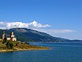 le lac et la nouvelle église de Mavrovo.
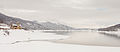 le lac et la nouvelle église de Mavrovo en hiver.
 L'ancienne église en partie engloutie.
 L'ancienne église en hiver.
 Le barrage et la tour de guet.


Voir aussi
- Mavrovo
- Zare Lazarevski
- Géographie de la République de Macédoine
Références
 Portail de la Macédoine du Nord
  Portail des lacs et cours d'eau
На других языках
[de] Mavrovosee
Der Mavrovosee (mazedonisch Мавровско Езеро .mw-parser-output .Latn{font-family:"Akzidenz Grotesk","Arial","Avant Garde Gothic","Calibri","Futura","Geneva","Gill Sans","Helvetica","Lucida Grande","Lucida Sans Unicode","Lucida Grande","Stone Sans","Tahoma","Trebuchet","Univers","Verdana"}Mavrovsko Ezero; albanisch Liqen/-i i Mavrovës) ist ein in der Mitte des 20. Jahrhunderts erstellter Stausee im Westen Nordmazedoniens. Er gehört zur Opština Mavrovo i Rostuša und liegt inmitten des Mavrovo-Nationalparkes in der Region Mavrovo sowie im Mavrovo-Tal. Die umliegenden Bergketten erreichen Höhen von bis zu 2000 Meter über Adria und gehören teilweise zum Gebirgsmassiv der Šar Planina (Norden) und teilweise zu demjenigen der Bistra (Süden). Dieser ist nur 20 Kilometer Luftlinie westlich vom See entfernt. Mit 13,7 km² Wasseroberfläche gehört der Mavrovosee zu den größeren Seen des Landes. Bei seiner tiefsten Stelle ist er 48 Meter tief.[1][en] Mavrovo Lake
Mavrovo Lake (Macedonian: Мавровско Езеро, romanized: Mavrovsko ezero) is situated in the Mavrovo region, in the Mavrovo and Rostuša municipality of the Republic of North Macedonia, less than 100 km from Skopje. It is an important tourist destination, being frequented for recreational activities such as swimming, boating and trout fishing during the summer; a distinctive building in the lake is the half-submerged church of Saint Nicholas. Since 1952 it is part of the Mavrovo National Park. With its surface of 13.7 km2 (3,400 acres), is one of the most extensive artificial lakes of the country.- [fr] Lac de Mavrovo
[ru] Мавровское озеро
Ма́вровское о́зеро[3][4] (макед. Мавровско Езеро)[2][5][4], также Мавровское водохранилище[6] — третье по величине водохранилище Северной Македонии. Устроено в 1957 году на реке Мавровска[mk][2] в Мавровском полье[mk][1].Другой контент может иметь иную лицензию. Перед использованием материалов сайта WikiSort.org внимательно изучите правила лицензирования конкретных элементов наполнения сайта.
WikiSort.org - проект по пересортировке и дополнению контента Википедии