geo.wikisort.org - Réservoir
Le lac Vanda est un lac salé situé dans la vallée de Wright, terre Victoria, dans la dépendance de Ross, en Antarctique.
Cet article est une ébauche concernant l’Antarctique.
Vous pouvez partager vos connaissances en l’améliorant (comment ?) selon les recommandations des projets correspondants.
| Lac Vanda | ||

| ||
| Administration | ||
|---|---|---|
| Pays | ||
| Géographie | ||
| Coordonnées | 77° 10′ S, 161° 50′ E | |
| Superficie | 5,2 km2 |
|
| Longueur | 5 km | |
| Largeur | 2 km | |
| Altitude | 143 m | |
| Profondeur · Maximale |
69 m |
|
| Volume | 0,16 km3 | |
| Hydrographie | ||
| Alimentation | Onyx | |
| Émissaire(s) | Aucun | |
| Géolocalisation sur la carte : Antarctique
| ||
| modifier |
||

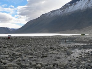
Le lac est long de 5 km et profond au maximum de 69 m[1]. Il s'agit de l'un des nombreux lacs salés des vallées libres de glace des monts Transantarctiques. L'Onyx, la plus longue rivière d'Antarctique, se jette dans le lac Vanda.
Le lac Vanda ne contient aucun poisson ; les seuls organismes vivants sont des microorganismes.
Sur sa côte, la Nouvelle-Zélande maintint la Vanda Station entre 1968 et 1995. Une station météorologique se situe néanmoins à l'embouchure de l'Onyx.
Voir aussi
Articles connexes
- Liste de lacs d'Antarctique
- Vanda Station
Liens internes
- Onyx
- Vallée de Wright
- Liste de lacs d'Antarctique
Notes et références
 Portail de l’Antarctique
  Portail des lacs et cours d'eau
На других языках
[de] Vandasee
Der Vandasee ist ein abflussloser See im Wright Valley im ostantarktischen Viktorialand. An seinem Ufer befand sich von 1968 bis 1995 die neuseeländische Vanda-Station.[en] Lake Vanda
Lake Vanda is a lake in Wright Valley, Victoria Land, Ross Dependency, Antarctica. The lake is 5 km (3.1 mi) long and has a maximum depth of 69 m (226 ft).[2] On its shore, New Zealand maintained Vanda Station from 1968 to 1995. Lake Vanda is a hypersaline lake with a salinity more than ten times that of seawater[3] and more than the salinity of the Dead Sea. Lake Vanda is also meromictic, which means that the deeper waters of the lake don't mix with the shallower waters.[4] There are three distinct layers of water ranging in temperature from 23 °C (73 °F) on the bottom to the middle layer of 7 °C (45 °F) and the upper layer ranges from 4–6 °C (39–43 °F).[5] It is only one of the many saline lakes in the ice-free valleys of the Transantarctic Mountains. The longest river of Antarctica, Onyx River, flows West, inland, into Lake Vanda. There is a meteorological station at the mouth of the river.- [fr] Lac Vanda
[it] Lago Vanda
Il lago Vanda è un lago ipersalino dell'Antartide situato nella valle di Wright, nella Terra della Regina Vittoria, Dipendenza di Ross. Sulle sue sponde la Nuova Zelanda ha mantenuto in funzione dal 1968 al 1995 la base antartica Stazione Vanda.[ru] Ванда (озеро)
Ванда — озеро в долине Райт на земле Виктории в Антарктиде, в которое впадает река Оникс. Длина озера 5 км, а максимальная глубина — 69 метров[1]. Объём воды — 0,16 км³.[источник не указан 1954 дня] Площадь поверхности — 5,2 км².[источник не указан 1954 дня]Другой контент может иметь иную лицензию. Перед использованием материалов сайта WikiSort.org внимательно изучите правила лицензирования конкретных элементов наполнения сайта.
WikiSort.org - проект по пересортировке и дополнению контента Википедии