geo.wikisort.org - Réservoir
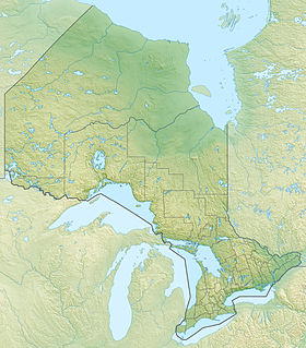
Le lac Seul est une étendue d'eau située à l'Ouest de la province de l'Ontario.
Pour les articles homonymes, voir Seul.
Ce lac est un reliquat de l'ancien lac proglaciaire Agassiz.
Le lac Seul reçoit une partie des eaux du bassin versant de la rivière Albany à la hauteur du lac Saint-Joseph dont elle est le principal émissaire.
Le lac est peuplé de poissons de la variété du Doré jaune, sorte de grande perche et de grand brochet.
Annexe
Article connexe
- Première Nation de Lac Seul
- Portail des lacs et cours d'eau
- Portail de l’Ontario
На других языках
[de] Lac Seul
Lac Seul ist ein großer sichelförmiger Stausee im Nordwesten der kanadischen Provinz Ontario im Kenora District.[en] Lac Seul
Lac Seul is a large, crescent shaped reservoir in Kenora District, northwestern Ontario, Canada. It is approximately 241 km (150 mi) long. It has a maximum (regulated) depth of 47.2 m, with a surface elevation of 357 m above sea level. Its level is raised in the summer and then drawn down in the winter months to reach points of as low as 16 feet below the maximum level. It is the second largest body of water entirely within the province of Ontario (Lake Nipigon being first). The lake consists of open water bays, narrow channels, and islands. It is a relatively shallow lake with many rock shoals. This provides a good habitat for walleye (also known as "yellow pickerel") and northern pike as well as yellow perch. During the Lac Seul project of 1968-1972 no muskelunge were noted in the catches of research nets set over those years. Significant numbers of whitefish, tullibee, burbot and cisco were noted as well although they infrequently were noted in the sport fishery. Lac Seul is noted for offering some of the best fishing in Ontario.- [fr] Lac Seul
[it] Lago Seul
Il lago Seul (Lac Seul) è un lago del Canada, situato nel nord-ovest dell'Ontario. A forma di mezzaluna, si estende per circa 241 km di lunghezza. La sua profondità massima è di 47,2 m, ed è posto a 357 m sul livello del mare. Fra i laghi completamente compresi all'interno dell'Ontario è il secondo per estensione, dopo il lago Nipigon. Nel lago entra il fiume English che poi ne esce proseguendo fino ad immettersi nel Fiume Winnipeg.[ru] Лак-Сёль
Лак-Сёль (англ. Lac Seul) — водохранилище в провинции Онтарио в Канаде. Расположено на северо-западе провинции. Одно из больших озёр Канады — площадь водной поверхности 1450 км², общая площадь — 1657 км², седьмое по величине озеро в провинции Онтарио[1]. Высота над уровнем моря 357 метров, колебания уровня озера до 3,5 метра. Сток из озера на запад по рекам Инглиш и Виннипег в озеро Виннипег. Ледостав с ноября по май[2]. В окрестностях озера развита лесная промышленность. Чистая вода и значительные запасы рыбы позволяют развивать рекреационные возможности озера. Объём озера был увеличен благодаря переброске части вод из бассейна реки Олбани, что позволило увеличить выработку электроэнергии ГЭС на реке Инглиш[3].Текст в блоке "Читать" взят с сайта "Википедия" и доступен по лицензии Creative Commons Attribution-ShareAlike; в отдельных случаях могут действовать дополнительные условия.
Другой контент может иметь иную лицензию. Перед использованием материалов сайта WikiSort.org внимательно изучите правила лицензирования конкретных элементов наполнения сайта.
Другой контент может иметь иную лицензию. Перед использованием материалов сайта WikiSort.org внимательно изучите правила лицензирования конкретных элементов наполнения сайта.
2019-2025
WikiSort.org - проект по пересортировке и дополнению контента Википедии
WikiSort.org - проект по пересортировке и дополнению контента Википедии


