geo.wikisort.org - Reservoir
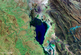
Uru Uru Lake is a lake in the Oruro Department in Bolivia. It is fed by the Desaguadero River and the Jach'a Jawira. It is situated at an elevation of 3,686 m, its surface area is 214 km2.
| Uru Uru Lake | |
|---|---|
 | |
 Uru Uru Lake  Uru Uru Lake | |
| Location | Oruro Department |
| Coordinates | 18°5′40″S 67°5′46″W |
| Primary inflows | Río Desaguadero |
| Primary outflows | Río Desaguadero, Laq'a Jawira |
| Basin countries | Bolivia |
| Surface area | 214 km2 (83 sq mi) |
| Max. depth | 1.5 m (4 ft 11 in) |
| Surface elevation | 3,686 m (12,093 ft) |
| Settlements | Oruro, Machacamarca |
 | |
Ramsar Wetland | |
| Official name | Lagos Poopó y Uru Uru |
| Designated | 11 July 2002 |
| Reference no. | 1181[1] |
The lake is formed by the flow of the Desaguadero River at its mouth into Lake Poopó, over the extensive sedimentation known as "Santo Tomás" from the small hermitage found there that was completely inundated. The formation dates to 1962. The river connects Lake Titicaca and Lake Poopó.
Ecology
The lake used to be a tourist attraction for boating and fishing, as it contained a large number of fish. During a long drought in 2016, the lake lost almost all of its water. This was described by local media and experts as an environmental catastrophe caused by several factors, including climate change and the use of water for mining.[2]
In 2021, a large part of the lake is covered by trash. Much of it is plastic from nearby Oruro where residents dump their refuse. There is also contamination from run-off from nearby mines as the town Oruro is an industrial mining center. The lake is polluted by heavy metals such as cadmium, zinc, and arsenic.[3][4]
See also
References
- "Lagos Poopó y Uru Uru". Ramsar Sites Information Service. Retrieved 25 April 2018.
- (in Spanish) Marcelo Tedesqui, El lago Uru Uru desaparece y se lleva vida y esperanza, La Patria (reprint from El Deber), 25 November 2016
- "Lake Uru-Uru in Bolivia covered in plastic waste". Kold.com. Retrieved 8 April 2021.
- Quintanilla, Victor (2019-07-30). "Communities request international support to save Bolivia's Poopó and Uru Uru lakes". Interamerican Association for Environmental Defense (AIDA). Retrieved 2021-04-14.
Capital: Oruro | ||
| Provinces |
|  |
| Municipalities (and seats) |
| |
| Authority control |
|
|---|
На других языках
[de] Uru-Uru-See
Der Uru-Uru-See ist ein See im Anden-Hochgebirge auf dem bolivianischen Altiplano wenige Kilometer südlich der Industriestadt Oruro.- [en] Uru Uru Lake
[fr] Lac Uru Uru
Le lac Uru Uru, en Bolivie, est un lac tectonique situé dans le département d'Oruro, qui fit partie de l'ancien lac intérieur de Michin. Il est relié au lac Titicaca par le Río Desaguadero, qui à son tour est connecté avec le lac Poopó. Depuis le 11 juillet 2002, le lac Uru Uru et le lac Poopó ont été déclarés sites Ramsar, dont la convention a pour but de préserver les zones humides de la planète[1].[ru] Уру-Уру
Уру-Уру (исп. Lago Uru Uru) — озеро рядом с городом Оруро, Боливия. Сформировалось на реке Десагуадеро в 1962 году после изменения её русла. Связано рекой с озёрами Титикака и Поопо.Другой контент может иметь иную лицензию. Перед использованием материалов сайта WikiSort.org внимательно изучите правила лицензирования конкретных элементов наполнения сайта.
WikiSort.org - проект по пересортировке и дополнению контента Википедии