geo.wikisort.org - Reservoir
Umiam Lake (locally known as Dam sait) is a reservoir in the hills 15 km (9.3 mi) north of Shillong in the state of Meghalaya, India. It was created by damming the Umiam River in the early 1960s. The principal catchment area of the lake and dam is spread over 225 square km.
This article includes a list of general references, but it lacks sufficient corresponding inline citations. (June 2022) |
| Umiam Lake | |
|---|---|
 View of Umiam Lake | |
 Umiam Lake Location of Umiam Lake | |
| Location | Meghalaya |
| Coordinates | 25.6532°N 91.8843°E |
| Type | Reservoir |
| Catchment area | 220 km2 (85 sq mi) |
| Basin countries | India |
| Settlements | Shillong |
History
Umiam Dam, which impounds the lake, was built by the Assam State Electricity Board in the early 1960s. The dam's original purpose was to store water for hydroelectric power generation. The Umiam Stage I powerhouse, north of the lake, has four 9-MW turbine-generators, which entered commercial operation in 1965. Umiam Stage I was the first reservoir-storage hydroelectric project commissioned in the northeastern region of India. (Umtru Hydroelectric Project, a run-of-river project with an original capacity of 8.4 MW, began operation in 1957.) Three more stages of the Umiam Project were subsequently built downstream.[1]
Tourist destination
The lake serves as a major tourist attraction for the state of Meghalaya. It is also a popular destination for water sport and adventure facilities. Tourists visit this spot for kayaking, water cycling, scooting, and boating.

Ecological effect
Apart from storing water for electricity generation, the lake also provides numerous ecosystem services at micro, meso and macro levels. Downstream irrigation, fisheries, and drinking water cater to local anthropogenic needs.
Toxic threat and silting
Due to the rising population of Shillong upstream of the lake, the lake is starting to become highly polluted. Also, there is the heavy problem of silting. An estimated 40,000 cubic metres (1,400,000 cu ft) of silt enters Umiam Lake every year. Causes range between upstream encroachments, deforestation, blockage of natural drainage systems, and unscientific mining et al. in the catchment area. Excessive silt load in the lake has lowered the storage.

Gallery
 Roadside view of Umiam Lake
 View of Umiam Lake
 View of Umiam Lake
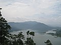 View of Umiam Lake
 Sunset at Umiam Lake
 View of Umiam Lake
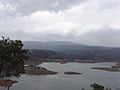 Magnificent Umiam lake
 Lakeside boats, Umiam Lake
 Umiam lake view


References
- "Umiam Stage - I Power House PH00820 -". Archived from the original on 26 October 2016. Retrieved 25 October 2016.
External links
- Umiam lake faces toxic threat
- Umiam Dam satellite map
- Umiam Lake Details
- Siltation and Pollution Contribute to Power Crisis in Shillong
- Pollution of Umiam Lake
Authority control | |
|---|---|
| General |
|
| National libraries | |
На других языках
- [en] Umiam Lake
[ru] Умиам
Умиам (англ. Umiam Lake) — водохранилище в штате Мегхалая в северо-восточной Индии в 15 км от города Шиллонга. Площадь водосбора 220 км², площадь самого озера 10 км кв[1]. Создано при строительстве ГЭС в 1965 году[2]. Помимо выработки электроэнергии, используются для орошения, рыболовства и обеспечения населения питьевой водой. Озеро привлекает любителей водных видов спорта[1].Другой контент может иметь иную лицензию. Перед использованием материалов сайта WikiSort.org внимательно изучите правила лицензирования конкретных элементов наполнения сайта.
WikiSort.org - проект по пересортировке и дополнению контента Википедии