geo.wikisort.org - Reservoir
Tasman Lake is a proglacial lake formed by the recent retreat of the Tasman Glacier in New Zealand's South Island.[5]
| Tasman Lake | |
|---|---|
 Lake Tasman and Mount Cook | |
 Tasman Lake | |
| Location | Aoraki / Mount Cook National Park, South Island |
| Coordinates | 43°41′S 170°10′E |
| Lake type | Proglacial lake |
| Primary outflows | Tasman River |
| Basin countries | New Zealand |
| Max. length | 7 km (4.3 mi)[1] |
| Max. width | 2 km (1.2 mi)[1] |
| Surface area | 6.91 km2 (2.67 sq mi) in 2013 |
| Max. depth | > 200 m (660 ft)[2] |
| Surface elevation | 715 m (2,346 ft)[3] |
| Frozen | most winters[4] |
In the early 1970s, there were several small meltwater ponds on the Tasman Glacier. By 1990, these ponds had merged into Tasman Lake.[6]
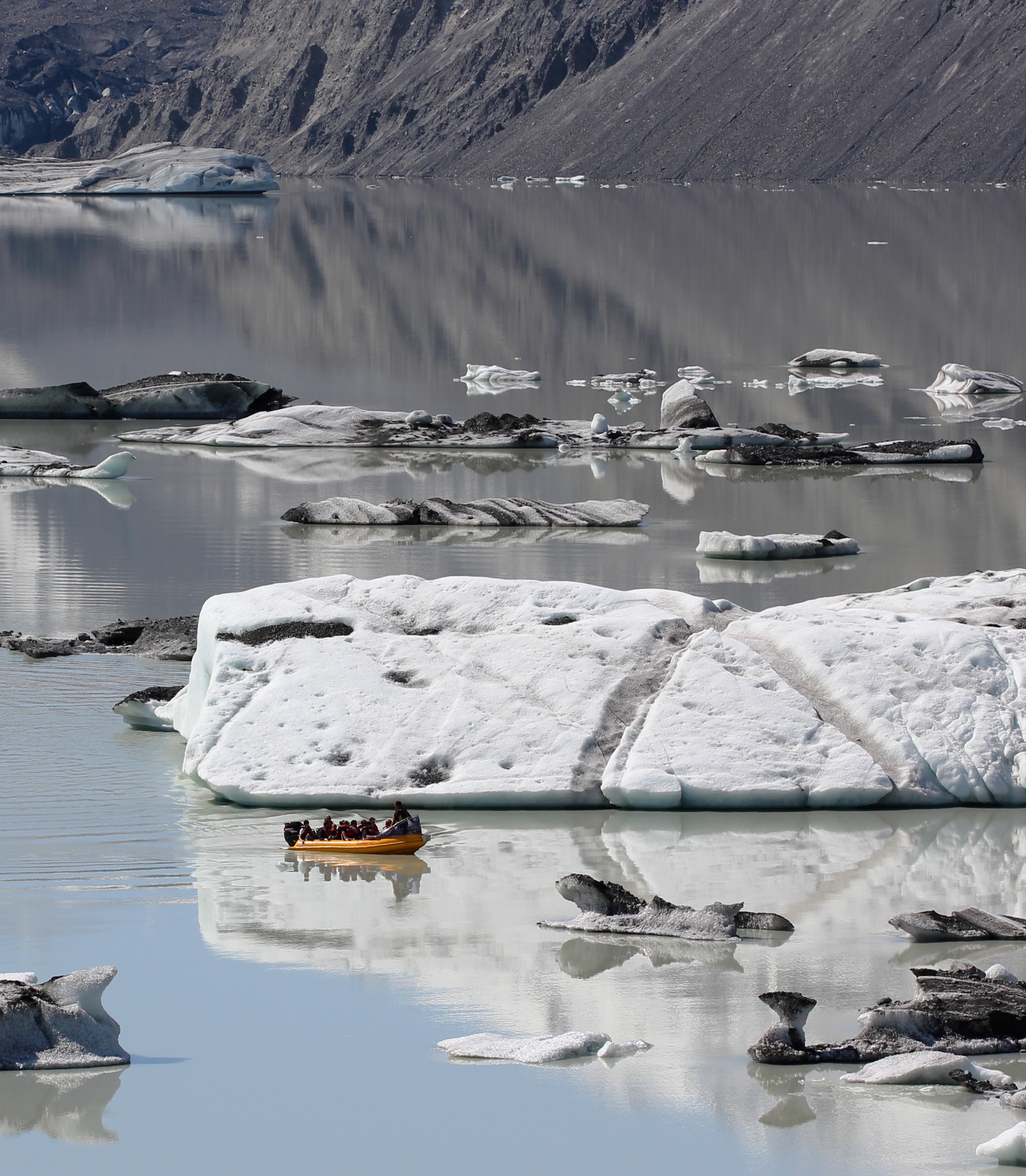
Tasman Lake has quickened the retreat of the Tasman Glacier. Initially it did so by undercutting the cliff at the end of the glacier, causing parts of the cliff to fall into the lake. Since 2006, however, a 50–60 m (160–200 ft) apron of submerged glacial ice projects out from the cliff, and icebergs periodically break off the apron and float away down the lake. Because more of the glacier is now in contact with the water, its rate of retreat has increased. By 2008 the lake was about 7 km (4 mi) long, 2 km (1 mi) wide and 245 m (800 ft) deep, having almost doubled in area since 2000.[7] It is expected to grow to a maximum length of about 16 km (9.9 mi) within the next one or two decades.[8]
Tasman Lake, the glacier and the surrounding mountains are part of Aoraki / Mount Cook National Park. Taking a boat tour among the icebergs on the Tasman Lake is now a popular tourist activity.[9] For safety reasons the small inflatable boats are not allowed closer than 1.5 km (0.9 mi) to the 50 m (160 ft) tall terminal face of Tasman Glacier.[10] Tasman Lake can be reached by road from the nearby Mount Cook Village and a short walk from the car park at the end of the road.
Like many other geographic places in both New Zealand and Australia, it is named after Dutch explorer Abel Janszoon Tasman.

See also
- Climate change in New Zealand
References
- "Tasman Glacier retreat extreme". Massey University. 30 April 2008. Retrieved 2016-09-14.
- Sahiban Kanwal (13 January 2015). "University of Canterbury researchers use hi-tech jetboat to research Tasman Glacier". Stuff. The Timaru Herald. Retrieved 2016-09-14.
- "Tasman Lake, Canterbury". NZ Topo Map. Land Information New Zealand. Retrieved 2016-09-14.
- Charles R. Warren & Martin P. Kirkbride (1998). Temperature and bathymetry of ice-contact lakes in Mount Cook National Park, New Zealand - New Zealand Journal of Geology and Geophysics. Vol. 41. Royal Society of New Zealand. pp. 133–143.
- "Place name detail: Tasman Lake". New Zealand Gazetteer. New Zealand Geographic Board. Retrieved 18 April 2008.
- Hochstein, M.P.; Claridge, D.; Henrys, S.A.; Pyne, A.; Nobes, D.C. and Leary, S.F. (1995). Downwasting of the Tasman Glacier, South Island, New Zealand: changes in the terminus region between 1971 and 1993 Archived 2008-10-22 at the Wayback Machine, New Zealand Journal of Geology and Geophysics 38 (1), 1-16.
- Dykes, Robert C.; Brook, Martin S.; Winkler, Stefan (2010). "The contemporary retreat of Tasman Glacier, Southern Alps, New Zealand, and the evolution of Tasman proglacial Lake since AD 2000". Erdkunde. 64 (2): 147–148. doi:10.3112/erdkunde.2010.02.03. Retrieved 4 December 2015.
- "Tasman Glacier retreat extreme". Massey University. 2008-04-23. Retrieved 2008-04-24.
- Temple, Philip (2009-12-11). "Deniers don't have a rapidly melting glacier to stand on". The New Zealand Herald. Retrieved 2010-02-23.
- Jeff Tollan (3 August 2010). "Tasman Glacier about to calve". Stuff. The Timaru Herald. Retrieved 2016-09-14.
External links
| Wikimedia Commons has media related to Tasman Lake. |
- New Zealand Department of Conservation - Aoraki / Mount Cook National Park
На других языках
[de] Tasman Lake
Der Tasman Lake ist ein Gletschersee, der durch den Rückzug des Tasman-Gletschers auf der Südinsel Neuseelands entstand.- [en] Tasman Lake
[ru] Тасман (озеро)
Тасман (англ. Tasman Lake) — моренное озеро[en] на территории национального парка Маунт-Кук в регионе Кентербери, остров Южный, Новая Зеландия[2]. Образовано в результате сравнительно недавнего отступления одноимённого ледника на север. В озеро впадает небольшая река Марчисон[en]. Высота над уровнем моря — 715 м[3].Другой контент может иметь иную лицензию. Перед использованием материалов сайта WikiSort.org внимательно изучите правила лицензирования конкретных элементов наполнения сайта.
WikiSort.org - проект по пересортировке и дополнению контента Википедии