geo.wikisort.org - Reservoir
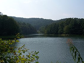
Stonecoal Lake Wildlife Management Area is located on 2,985 acres (1,208 ha)[2] in Lewis and Upshur counties, east of Weston, West Virginia, United States. The wildlife management area is centered on Stonecoal Lake (38°59′17″N 80°22′41″W), a hydroelectric project owned by Allegheny Energy. The lake was built in 1972 to provide water to Allegheny Energy's coal-fired power plant in Harrison County.
| Stonecoal Lake Wildlife Management Area | |
|---|---|
IUCN category V (protected landscape/seascape)[1] | |
 Stonecoal Lake near the dam | |
 Location of Stonecoal Lake Wildlife Management Area in West Virginia | |
| Location | West Virginia, United States |
| Coordinates | 38°58′15″N 80°19′49″W |
| Area | 2,985 acres (12.08 km2)[2] |
| Elevation | 1,145 ft (349 m) |
| Operator | West Virginia Division of Natural Resources, Wildlife Resources Section |
| Website | WVDNR District 3 Wildlife Management Areas |
References
- "Stonecoal Lake Wildlife Management Area". Protected Planet. IUCN. Retrieved 30 April 2018.
- WVDNR District 3 Wildlife Management Areas, Accessed April 3, 2008 Archived May 7, 2008, at the Wayback Machine
- Winters, Kelly "Stonecoal Lake." e-WV: The West Virginia Encyclopedia. 5 November 2010. Web. 25 November 2015
External links
Текст в блоке "Читать" взят с сайта "Википедия" и доступен по лицензии Creative Commons Attribution-ShareAlike; в отдельных случаях могут действовать дополнительные условия.
Другой контент может иметь иную лицензию. Перед использованием материалов сайта WikiSort.org внимательно изучите правила лицензирования конкретных элементов наполнения сайта.
Другой контент может иметь иную лицензию. Перед использованием материалов сайта WikiSort.org внимательно изучите правила лицензирования конкретных элементов наполнения сайта.
2019-2025
WikiSort.org - проект по пересортировке и дополнению контента Википедии
WikiSort.org - проект по пересортировке и дополнению контента Википедии