geo.wikisort.org - Reservoir
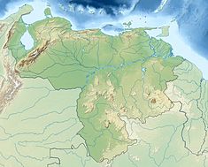
The Macagua Dam, officially known as Antonio José de Sucre, is an embankment dam with concrete gravity sections on the Caroní River in Ciudad Guayana, Bolívar State, Venezuela. It is 10 kilometres (6.2 mi) upstream from the confluence of the Caroni and Orinoco Rivers, 81 km (50 mi) downstream of the Guri Dam and 22 kilometres (14 mi) downstream of the Caruachi Dam. The dam's main purpose is hydroelectric power generation and it was later named after Antonio José de Sucre.
| Macagua Dam | |
|---|---|
 | |
| Official name | Hidroeléctrica Antonio José de Sucre |
| Country | Venezuela |
| Location | Ciudad Guayana in Bolívar State |
| Coordinates | 08°18′14″N 62°40′05″W |
| Construction began | 1956 |
| Opening date | 1961 |
| Owner(s) | CVG Electrificación del Caroní, C.A. |
| Dam and spillways | |
| Type of dam | Concrete gravity/embankment |
| Impounds | Caroní River |
| Height | 69 m (226 ft) |
| Length | 3,537 m (11,604 ft) |
| Reservoir | |
| Creates | Macagua Reservoir |
| Total capacity | 363,000,000 m3 (294,289 acre⋅ft) |
| Surface area | 47.4 km2 (18.3 sq mi) |
| Power Station | |
| Commission date | Macagua I: 1961 Macagua II/III:1996 |
| Turbines | 20 Macagua I: 1x 79.5 MW (106,600 hp) Francis turbine, 5 x 64 MW (86,000 hp) Francis turbines Macagua II: 12 x 216 MW (290,000 hp) Francis turbines Macagua III: 2 x 88 MW (118,000 hp) Kaplan turbines |
| Installed capacity | 3,167.5 MW (4,247,700 hp) |
| Annual generation | 15,200 GWh (55,000 TJ) |
Dam

The Macagua Dam is a 69-metre (226 ft) tall and 3,537-metre (11,604 ft) long embankment dam with concrete gravity sections for each of the three different power stations.[1] The dam supplies water to three power stations with a generation capacity of 3,167.5 megawatts (4,247,700 hp).
Power plants
Macagua I
Macagua I 8°18′02″N 62°39′52″W was constructed from 1956 to 1961 and it contains 6 x 64 megawatts (86,000 hp) Francis turbine-generators for an installed capacity of 384 megawatts (515,000 hp). Currently, Macagua I is undergoing a refurbishment in order to increase the capacity of each generator from 64 MW to 79.5 megawatts (106,600 hp). The first generator was complete in 2010, the second is expected to be completed in 2011 and another each year thereafter.[2][3]
Macagua II
Macagua II 8°18′14″N 62°40′04″W contains 12 x 216 megawatts (290,000 hp) Francis turbine-generators for an installed capacity of 1,592 megawatts (2,135,000 hp). Macagua II began operation in 1996 and was inaugurated in January 1997.[4]
Macagua III
Macagua III 8°18′09″N 62°40′46″W contains 2 x 88 megawatts (118,000 hp) Kaplan turbine-generators for an installed capacity of 176 megawatts (236,000 hp). Macagua II began operation in 1996 and was inaugurated in January 1997.[4]
External links
| Wikimedia Commons has media related to Macagua Dam. |
References
- "Dams - Macagua II" (in Spanish). Covenpre VENCOLD. Archived from the original on 25 April 2011. Retrieved 13 January 2011.
- "Ongoing Projects - Rehabilitation of Hydroelectric Powerhouse Antonio José de Sucre in Macagua" (in Spanish). Electrification del Caroni CA. Archived from the original on 27 July 2011. Retrieved 13 January 2011.
- "Refurbishment and rehabilitation of Macagua I moving forward". IMPSA. 2010-10-28. Archived from the original on 13 July 2011. Retrieved 13 January 2011.
- "Hydroelectric Antonio José de Sucre in Macagua" (in Spanish). Electrification del Caroni CA. Archived from the original on 27 July 2011. Retrieved 13 January 2011.
На других языках
[de] Macagua-Talsperre
Die Macagua-Talsperre, offiziell benannt nach Antonio José de Sucre, ist eine Talsperre am Río Caroní in Ciudad Guayana im Staat Bolívar in Venezuela. Das Absperrbauwerk steht 10 km flussaufwärts des Zusammenflusses des Caroni mit dem Orinoco. Der Zweck der Talsperre ist Wasserkraftgewinnung. Sie wurde nach Antonio José de Sucre benannt. Der Gesamtkomplex heißt „Complejo Hidroeléctrico 23 de Enero“.- [en] Macagua Dam
[es] Represa de Las Macagua
La Represa de Macagua, donde se ubica la Central Hidroeléctrica "Antonio José de Sucre", es una represa cuyo terraplén son secciones de concreto a gravedad sobre el río Caroní en Ciudad Guayana, Estado Bolívar, Venezuela. Se encuentra a 10 km (6 millas) río arriba de la confluencia de los ríos Caroní y Orinoco, 81 km (50 millas) aguas abajo de la represa de Guri y 22 kilómetros (14 millas) aguas abajo de la Represa de Caruachi. Objetivo principal de la presa es la generación de energía hidroeléctrica[1]Другой контент может иметь иную лицензию. Перед использованием материалов сайта WikiSort.org внимательно изучите правила лицензирования конкретных элементов наполнения сайта.
WikiSort.org - проект по пересортировке и дополнению контента Википедии
