geo.wikisort.org - Reservoir
Lake Čepić (Croatian: Čepićko jezero, Raško, Kožljansko, Sisolsko, Italian: Lago d'Arsa) was the only natural lake in Istria, Croatia. It was drained in 1932 with a 4,250 m long tunnel near Plomin to the sea. The surface of the vast green valley was transformed into a fertile field for agriculture. The field's area is around 7 km2 (elevation 24 m), and the Boljunčica River flows into it, while from it Raša River.

History
The lake was located in eastern Istria, on the western and south-western slopes of Mount Učka (to the west of uplift Sisol, elevation 833 m). South of the lake (now filled) is the town Kršan, to the east the ruins of Kožljak Castle, while to the west and north was the Pauline monastery of St. Mary, and the villages of Čepić, Kostrčani, Brdo Jesenovik, Nova Vas, and Šušnjevica, mostly inhabited by Istro-Romanians.

The lake's area was between 5.4 and 8.6 km2, depending on the precipitation and the water supply from the Boljunčica River. Its width was 2.5 km at most, while its length was nearly 4 km. The depth of the lake was between 1 and no more than 2.5 metres. The lake was covered with reed and sedge, and was rich in fish (eel, carp, chub), and birds (wild duck, white stork, swan). However, it was also known for malarial mosquitoes and flooding.
The lake was recorded in the old topographic maps, the oldest from 1525 and 1563. In 1679 by Valvasor engravings as Zhepizer See, later as Sisol lake, and Gessaro in 1753. The first documents about lake drainage dates to the end of 18th century by Austria and Venice. In 1898, during the rule of Austria, a project was developed to halve the lake surface to around 300 ha. In 1899 it was accepted by Istrian parliament, and the work began in 1902, but was stopped in 1908 due to lack of financial support. When Istria came under the rule of Italy in 1918, a consortium was established in 1920 for regulating the course of the Raša River, Conzorzio di Bonifica del Sistema dell' Arsa, and the work on the new project began in 1928.
The tunnel, which extended from the southern point of the lake to the Gulf of Plomin, was 4,560 metres long, built by between 96 and 262 workers per year, and was finished after four years in October 1932. The dam was opened on 11 December of the same year, and the water reached the gulf in 26 minutes. By January 1933, the lake water, totaling 20 million cubic metres, had drained almost completely.
Gallery
 Čepić, with boats and fishermen on the lake
 The field seen from the village of Jesenovik
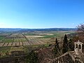 Panorama of the field seen from Kožljak


References
- Milevoj, Marijan (2014). S ove strane Učke [On this side of Učka] (in Croatian). Labin: Mathias Flacius. pp. 77–81. ISBN 978-953-6875-54-2.
- Načinović, Danijel. "Čepić Lake". IstriaNet (in Croatian and English). Archived from the original on 18 June 2002. Retrieved 26 January 2015.
- Marijan, Milevoj; Načinović, Danijel. "Ćepić Lake". IstriaNet. Retrieved 20 August 2015.[dead link]
- Other sources
- "Čepićko polje" (in Croatian). Croatian Encyclopedia.
- "Čepićko polje" (in Croatian). Istrian Encyclopedia. 2008.
External links
 Media related to Čepićko polje at Wikimedia Commons
На других языках
- [en] Lake Čepić
[it] Lago d'Arsa
Il lago d'Arsa detto anche lago di Cepich (in croato Čepićko jezero) era il più grande lago dell'Istria. Data la sua conformazione e l'ampia zona paludosa che ne contornava le rive, è stato per secoli la principale concausa delle febbri malariche che infestarono una parte dell'Istria. Il suo immissario era il torrente Bogliunsizza. Oggi il lago più esteso dell'Istria è il lago artificiale di Buttoniga nei pressi di Pisino.Другой контент может иметь иную лицензию. Перед использованием материалов сайта WikiSort.org внимательно изучите правила лицензирования конкретных элементов наполнения сайта.
WikiSort.org - проект по пересортировке и дополнению контента Википедии