geo.wikisort.org - Reservoir
Lake Murray is the largest lake in Papua New Guinea. It is located in Lake Murray Rural LLG, Middle Fly District, Western Province at 7°S 141.5°E, which covers approximately 647 km²[1] and in the wet season increases to five times the size. It has a highly convoluted shoreline more than 2000 km long. The lake has been a source of nourishment for many of the local peoples. Freshwater sawfish have been caught in its shallow waters to feed the crocodiles in a farming operation.
| Lake Murray | |
|---|---|
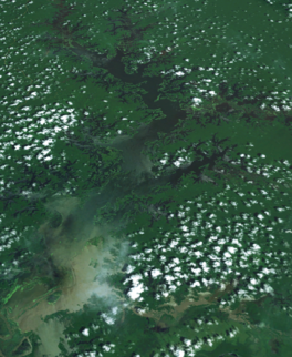 Landsat image | |
 Lake Murray | |
| Location | Western Province |
| Coordinates | 7°S 141.5°E |
| Primary inflows | June, Boi, Bwe, Kaim, Mamboi Rivers |
| Primary outflows | Herbert River → Strickland River → Fly River → Gulf of Papua |
| Basin countries | Papua New Guinea |
| Max. length | 63 km (39 mi) |
| Max. width | 18 km (11 mi) |
| Surface area | 647 km2 (250 sq mi) |
| Max. depth | 10 m (33 ft) |
| Shore length1 | 2,038 km (1,266 mi) |
| Surface elevation | 59 m (194 ft) |
| Settlements | Lake Murray |
| 1 Shore length is not a well-defined measure. | |
Indigenous tribes of around 5000 people own the lake and the surrounding one million hectares of forest.[2]
Lake Murray is known for a large population of peacock bass that were introduced by Indian merchants.
 From space (false color)

Illegal logging
In 2003, logging company Concord Pacific was forced out of the area by Greenpeace and other NGO's. 100,000 hectares of ancient forest was degraded by the logging along the Kiunga-Aiambak road.[2]
Greenpeace Global Forest Rescue Station (GFRS)
Lake Murray was the site of a Greenpeace Australia Pacific Global Forest Rescue Station. Forty volunteers from 25 countries worked with the local Kuni, Begwa and Pari tribes to identify and mark land ownership.[3] The boundary marking was the precursor to a community based eco-forestry project.[4] Ecotimber has since been harvested, shipped to Australia and sold with the benefit of Forestry Stewardship Council certification.
See also
- Lake Murray languages
References
- CSIRO PUBLISHING - Marine & Freshwater Research
- [dead link]
- "Global Forest Rescue Station | Greenpeace International". Greenpeace.org. 2007-10-08. Retrieved 2012-01-07.
- "Ecoforestry: Taking back the forest". Greenpeace Australia Pacific. c. 2006. Archived from the original on September 18, 2009. Retrieved 2009-10-09.
This Western Province geography article is a stub. You can help Wikipedia by expanding it. |
На других языках
[de] Lake Murray
Der Lake Murray ist ein See im Middle Fly Distrikt der Western Province. Er ist der größte See Papua-Neuguineas. Etwa 5000 Menschen leben in kleinen Dörfern am Ufer und auf kleinen Inseln des Sees. Der Wald, der den See umgibt, erstreckt sich über eine Fläche von einer Million Hektar.[1]- [en] Lake Murray (Papua New Guinea)
[ru] Марри (озеро)
Ма́рри[1] (англ. Lake Murray) — крупнейшее озеро Папуа — Новой Гвинеи и всей Австралазии.[2] Расположено на территории Западной провинции страны на территории низменности (максимальная глубина — 7 м), находящейся к северу от слияния рек Стрикленд и Флай. Общая площадь озера составляет 647 км², однако в сезон дождей она может значительно увеличиваться.[3] Воды Марри впадают в реку Стрикленд через реку Херберт. Однако во время сильных дождей случается, что воды реки Стрикленд впадают в озеро, а не наоборот.[3]Другой контент может иметь иную лицензию. Перед использованием материалов сайта WikiSort.org внимательно изучите правила лицензирования конкретных элементов наполнения сайта.
WikiSort.org - проект по пересортировке и дополнению контента Википедии