geo.wikisort.org - Reservoir
Lake Metigoshe State Park is a public recreation area occupying some 1,500 acres (610 ha) on the shores of Lake Metigoshe in the Turtle Mountains, 14 miles northeast of Bottineau, North Dakota, on the Canada–US border.[3] The state park lies adjacent to the southwest corner of the much larger Turtle Mountain Provincial Park in Manitoba. A small portion of the lake extends northward into the Rural Municipality of Winchester but is not part of either park.
| Lake Metigoshe State Park | |
|---|---|
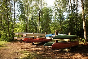
 Lake Metigoshe State Park, August 2013 | |
| Location | Roland Township, Bottineau County, North Dakota, United States |
| Nearest city | Bottineau, North Dakota |
| Coordinates | 48°59′12″N 100°19′26″W[1] |
| Area | 1,508.53 acres (6.1048 km2)[2] |
| Elevation | 2,152 ft (656 m)[1] |
| Designation | North Dakota state park |
| Established | 1937 |
| Administrator | North Dakota Parks and Recreation Department |
| Website | Lake Metigoshe State Park |
History
The name Lake Metigoshe is derived from the Ojibwe phrase mitigoshi-waashegami-zaaga'igan meaning "clearwater lake of scrub-oaks." The area was also once home to the Blackfoot, Hidatsa, and Assiniboine peoples.[4]
The park was developed by workers with the WPA who arrived at the site beginning in 1934. Their improvements included construction of a lodge, recreation rooms large enough for 200 people, roads, and various out buildings.[5] A stone inscribed "WPA 1938" found near the park entrance commemorates their work.[6] The park was formally established on February 17, 1937.[4]
Activities and amenities
The park offers swimming, canoeing, sailing, water-skiing and other water sports, modern and primitive camping areas, and picnicking. Lake Metigoshe has northern pike, walleye, and perch for fishing. Winter activities include snowmobiling, cross-country skiing, skating, sledding, and ice fishing.[3] The Turtle Mountain Outdoor Learning Center offers ecology, conservation, and outdoor recreation programs.[7]
Events
The Club de Skinautique water-skiers practice and perform on Lake Metigoshe. Known as the "Skinautiques," the club has performed water skiing shows every summer since 1958.[8]
References
- "Lake Metigoshe State Park". Geographic Names Information System. United States Geological Survey.
- "State Parks Data Table". North Dakota Geographic Information Systems. December 26, 2018. Retrieved May 25, 2020.
- "Lake Metigoshe State Park". North Dakota Parks and Recreation Department. Retrieved May 25, 2020.
- "Lake Metigoshe State Park: History". North Dakota Parks and Recreation Department. Archived from the original on May 22, 2012. Retrieved July 4, 2014.
- "Historical Overview". North Dakota Parks and Recreation Department. Archived from the original on December 8, 2017. Retrieved December 13, 2017.
- "WPA Rock at Lake Metigoshe". North Dakota Parks and Recreation Department. Archived from the original on February 11, 2017. Retrieved February 5, 2017.
- "Outdoor Learning Centers". North Dakota Parks and Recreation Department. Retrieved July 4, 2014.
- "About Us". Club de Skinautique. Retrieved July 4, 2014.
External links
- Lake Metigoshe State Park North Dakota Parks and Recreation Department
- Lake Metigoshe State Park Map North Dakota Parks and Recreation Department
Другой контент может иметь иную лицензию. Перед использованием материалов сайта WikiSort.org внимательно изучите правила лицензирования конкретных элементов наполнения сайта.
WikiSort.org - проект по пересортировке и дополнению контента Википедии
