geo.wikisort.org - Reservoir
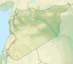
Lake Homs (Arabic: بحيرة حمص) (also called Lake Qattinah, Arabic: بحيرة قطينة) is a lake near Homs, Syria, fed by the Orontes River. The lake is 15 km (9.3 mi) from the city of Homs, and spans over 60 km2 (23 sq mi).[1]
| Lake Homs | |
|---|---|
| Lake Qattinah | |
 Satellite image of Lake Homs | |
 Lake Homs | |
| Location | Homs Governorate |
| Coordinates | 34.6434°N 36.5728°E |
| Type | Reservoir |
| Native name |
|
| Primary inflows | Orontes River |
| Primary outflows | Orontes River |
| Basin countries | Syria |
| Surface area | 60 km2 (23 sq mi) |
| Settlements | Homs |
The lake is artificial, created by the Lake Homs Dam at its northern end. The dam's original structure was one of the most visible works of ancient engineering in Syria and in the Fertile Crescent. Built by the ancient Romans, the dam had created a reservoir whose water was conducted to nearby fields through a network of canals.[2]
References
- "新在线伊人,久操综合在线,综合导航视频网-2022最新导航持续更新中". Archived from the original on 2008-05-14.
- Dumper, 2007, p.171.
Bibliography
- Dumper, Michael; Stanley, Bruce E.; Abu-Lughod, Janet L. (2007), Cities of the Middle East and North Africa: A Historical Encyclopedia, ABC-CLIO, ISBN 978-1-57607-919-5
На других языках
[de] See von Homs
Der See von Homs ist ein römischer Stausee nahe der syrischen Stadt Homs, der bis heute in Nutzung ist.- [en] Lake Homs
[fr] Lac de Homs
Le lac de Homs (en arabe : بحيرة حمص) est un lac artificiel situé en Syrie, dû à la retenue des eaux de l'Oronte par une digue en amont de la ville de Homs[1].Текст в блоке "Читать" взят с сайта "Википедия" и доступен по лицензии Creative Commons Attribution-ShareAlike; в отдельных случаях могут действовать дополнительные условия.
Другой контент может иметь иную лицензию. Перед использованием материалов сайта WikiSort.org внимательно изучите правила лицензирования конкретных элементов наполнения сайта.
Другой контент может иметь иную лицензию. Перед использованием материалов сайта WikiSort.org внимательно изучите правила лицензирования конкретных элементов наполнения сайта.
2019-2025
WikiSort.org - проект по пересортировке и дополнению контента Википедии
WikiSort.org - проект по пересортировке и дополнению контента Википедии