geo.wikisort.org - Reservoir
Goshiki-numa (五色沼), is a cluster of five volcanic lakes situated at the foot of Mount Bandai in the center of the lake district of Bandai-kōgen, Kitashiobara, Fukushima, Japan.
| Goshiki-numa | |
|---|---|
 | |
 Goshiki-numa | |
| Location | Kitashiobara, Fukushima |
| Coordinates | 37.653179°N 140.08667°E |
| Type | tectonic lake |
| Native name | 五色沼 (Japanese) |
| Basin countries | Japan |
| Surface elevation | 300 m (980 ft) |
Goshiki-numa formed when Mount Bandai erupted on July 15, 1888, destroying dozens of villages and killing approximately 500 people while creating hundreds of lakes and tarns.[1]
The eruption completely rearranged the landscape, creating the Bandai-kōgen plateau and damming local rivers. The eruption imparted mineral deposits to the Five Colored Lakes giving each of them their own delicate color, ranging from reddish green to cobalt blue. The colors of each lake mysteriously fluctuate throughout the year with the weather. Since the eruption, Goshiki-numa has become a popular tourist destination. An approximately four-kilometer walking path from Lake Bishamon, the largest of the five lakes, to Lake Hibara affords people a view of all five lakes.[2]
Gallery
 Bishamon-numa
 Aka-numa
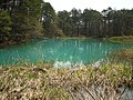 Ao-numa
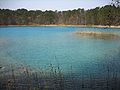 Benten-numa
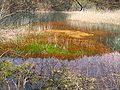 Midoro-numa


Notes
- Rowthorn C., page 454
- Takeda T., page 174.
References
- Rowthorn, Chris (2005), Japan, Lonely Planet, ISBN 1-74059-924-1
- Takeda, Toru; Hishinuma, Tomio; Kamieda, Kinuyo; Dale, Leigh; Oguma, Chiyoichi (August 10, 1988), Hello! Fukushima - International Exchange Guide Book (1988 ed.), Fukushima City: Fukushima Mimpo Press
External links
| Wikimedia Commons has media related to Goshikinuma (Kitashiobara, Fukushima). |
This Fukushima Prefecture location article is a stub. You can help Wikipedia by expanding it. |
На других языках
- [en] Goshiki-numa
[fr] Lac Goshiki
Le lac Goshiki (五色沼, Goshiki-numa?), est un groupement de cinq lacs de cratères situé au pied du mont Bandai dans le nord de la préfecture de Fukushima au Japon.Другой контент может иметь иную лицензию. Перед использованием материалов сайта WikiSort.org внимательно изучите правила лицензирования конкретных элементов наполнения сайта.
WikiSort.org - проект по пересортировке и дополнению контента Википедии