geo.wikisort.org - Reservoir
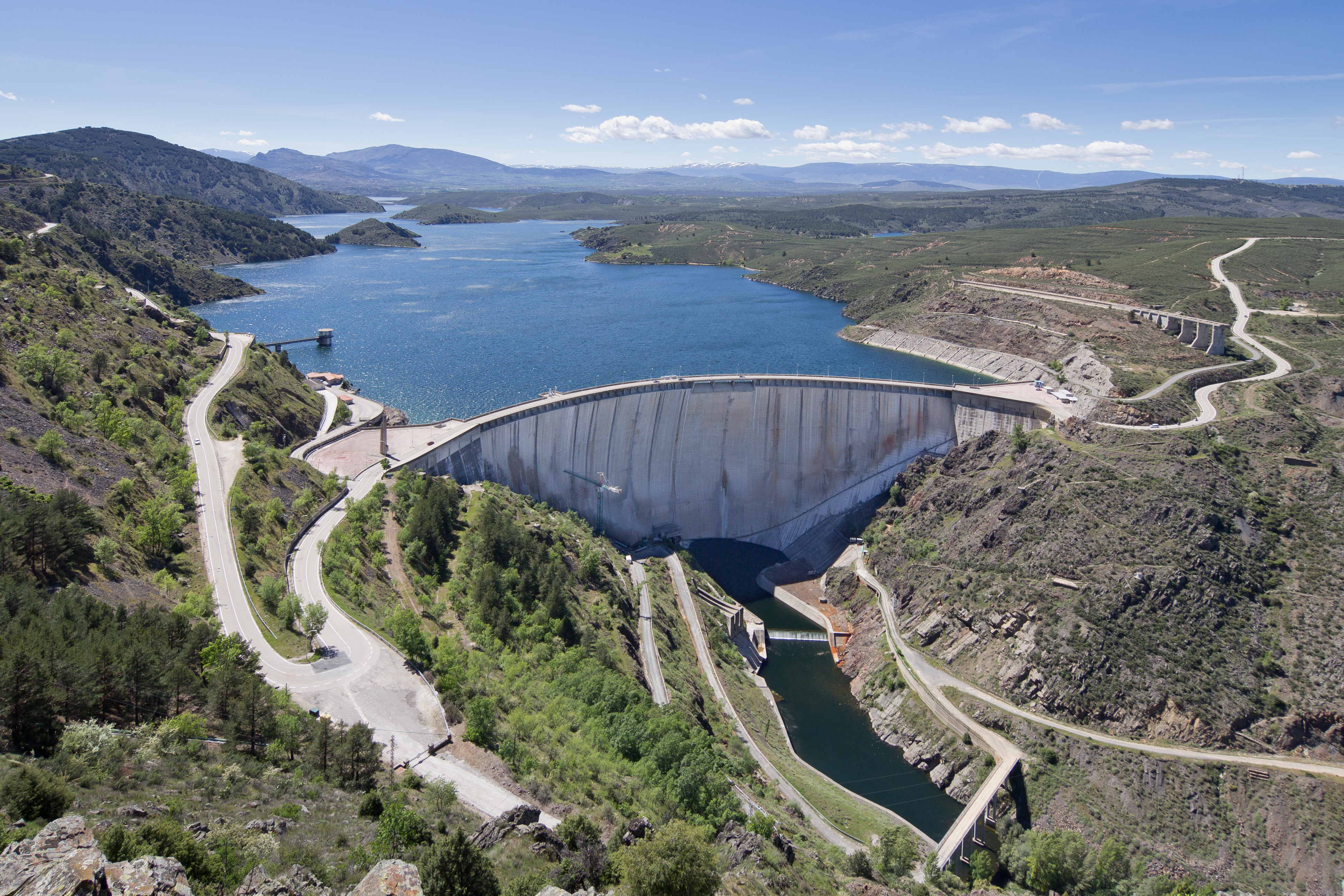
El Atazar Dam is an arch dam built near Madrid, Spain on the Lozoya River, very close to where the Lozoya joins the Jarama. The curved design of the dam is optimum for the narrow gorge in which it was built to retain water in the reservoir. Arch dams are thin and require less material to construct than other dam types.[1]
| El Atazar Dam | |
|---|---|
 The dam in 2014 | |
| Country | Spain |
| Location | Community of Madrid |
| Coordinates | 40°54′44″N 3°28′24″W |
| Status | Completed |
| Construction began | 1968 |
| Dam and spillways | |
| Height (foundation) | 134 m (440 ft) |
| Length | 52.3 m (171.6 ft) |
| Reservoir | |
| Creates | El Atazar Reservoir |
| Total capacity | 426 hm3 (1.50×10¹⁰ cu ft) |
| Surface area | 10.7 km² |

When the dam was built, the decision was made to use the dam to store and regulate water only and not to provide energy. Construction started on the dam in 1968 and finished in 1972.
Design
The dam is 134 m (440 ft) high and 52.3 m (171.6 ft) wide at the foundation. The reservoir capacity is 424,000,000 m3 (344,000 acre feet). It is a double curvature concrete arch buttress design.[2]
Problems
Monitoring of the dam revealed abnormal movement. Although dams normally move, the left side of the El Atazar Dam was moving more than the right because a support built on the dam's right made that side less flexible. In 1977 a crack was noticed in the dam. By 1979 the crack had grown to 46 m (150 ft) in length and was repaired. Inspection in 1983 revealed that the settling in the foundations and the movements of the dam had caused fracturing in the rock, resulting in significantly increasing the foundation's permeability. The crack has been treated and since then the problems have abated.[3]
Power plant
The dam supports a hydroelectric power plant with a nameplate capacity of 9,56 MW. Its annual generation lies between 18,66 (2012) and 44,49 (1998) GWh. The power station contains 2 Francis turbine-generators with 4,78 MW (5,4 MVA) each. The turbine rotation is 500 rpm. The hydraulic head is 56 m. Maximum flow per turbine is 8 m³/s.[4]
Gallery


Notes
- "Dam basics". PBS. Retrieved 2006-12-31.
- "El Atazar Background". Archived from the original on 2006-12-30. Retrieved 2006-12-31.
- "El Atazar Problem". Sim Science. Archived from the original on 27 September 2006. Retrieved 20 September 2018.
- "LAS ENERGÍAS RENOVABLES EN LA COMUNIDAD DE MADRID" (PDF) (in Spanish). www.fenercom.com. p. 57, 255–256. Retrieved 2020-09-12.
External links
- How is the way to build a Dam ?
- Sociedad Española de Presas y Embalses (in Spanish) profile
На других языках
[de] Talsperre El Atazar
Die Talsperre El Atazar (spanisch Presa de El Atazar) ist eine Talsperre mit Wasserkraftwerk in den Gemeinden El Atazar und Patones, Autonome Gemeinschaft Madrid, Spanien. Sie staut den Lozoya zu einem Stausee auf. Die Talsperre dient in erster Linie der Trinkwasserversorgung und daneben noch der Bewässerung und der Stromerzeugung. Mit ihrem Bau wurde 1962[1] (bzw. im Oktober 1965)[2][3] begonnen; sie wurde im Dezember 1971[2] (bzw. 1972)[4][5] fertiggestellt. Die Talsperre wurde am 10. April 1972 durch Franco eingeweiht.[1][3] Sie ist im Besitz von Canal de Isabel II.- [en] El Atazar Dam
Другой контент может иметь иную лицензию. Перед использованием материалов сайта WikiSort.org внимательно изучите правила лицензирования конкретных элементов наполнения сайта.
WikiSort.org - проект по пересортировке и дополнению контента Википедии