geo.wikisort.org - Reservoir
The Burgumer Mar (Dutch: Bergumermeer) is a lake near the town of Burgum in the Dutch province of Friesland. The lake was formed during the last ice age. It is a popular water sports area with multiple yacht harbours. The Princess Margriet Canal splits the lake into a northern and southern part.
This article needs additional citations for verification. (December 2019) |
| Burgumer Mar | |
|---|---|
 Burgumer Mar  Burgumer Mar | |
 | |
| Location | Friesland |
| Coordinates | 53°11′30″N 6°02′30″E |
| Basin countries | Netherlands |
| Surface area | 360 ha (890 acres) |
Since March 15, 2007, the West Frisian name Burgumer Mar is the official name; before that date the Dutch name was the official one[1]). The villages Jistrum, Eastermar and Sumar together with Burgum border the lake.
References
- Waternamen in Fryslân Archived September 27, 2007, at the Wayback Machine
External link
 Media related to Burgumer Mar at Wikimedia Commons
| Administrative Centre | 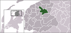 | |
|---|---|---|
| Villages |
| |
| Hamlets |
| |
| Landmarks |
| |
| Lakes |
| |
На других языках
[de] Burgumermar
Das Burgumermar ist ein fischreicher See östlich des Ortes Burgum in der niederländischen Provinz Friesland (Gemeinde Tytsjerksteradiel). Er ist ein populäres Wassersport-Gebiet mit mehreren Yachthäfen. Der Prinses-Margriet-Kanal durchfließt den See in Ost-West-Richtung und verbindet ihn mit dem Wasserstraßennetz. Das Bergumer Meer hat einen Umfang von ca. 11 km.- [en] Burgumer Mar
Текст в блоке "Читать" взят с сайта "Википедия" и доступен по лицензии Creative Commons Attribution-ShareAlike; в отдельных случаях могут действовать дополнительные условия.
Другой контент может иметь иную лицензию. Перед использованием материалов сайта WikiSort.org внимательно изучите правила лицензирования конкретных элементов наполнения сайта.
Другой контент может иметь иную лицензию. Перед использованием материалов сайта WikiSort.org внимательно изучите правила лицензирования конкретных элементов наполнения сайта.
2019-2026
WikiSort.org - проект по пересортировке и дополнению контента Википедии
WikiSort.org - проект по пересортировке и дополнению контента Википедии