geo.wikisort.org - Reservoir
Balsam Lake is a lake in the City of Kawartha Lakes in Central Ontario, Canada.[1][2][3][4] It is in the Great Lakes Basin, is one of the lakes of the Kawartha Lakes, and is at the summit of the Trent–Severn Waterway.
| Balsam Lake | |
|---|---|
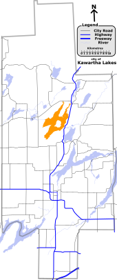
 Balsam Lake Location in Southern Ontario | |
| Location | Kawartha Lakes, Ontario |
| Group | Kawartha Lakes |
| Coordinates | 44°34′50″N 78°50′30″W[1] |
| Primary inflows | Gull River, Staples River, Corben Creek |
| Primary outflows | Rosedale River, Trent Canal |
| Catchment area | 115 km2 (44 sq mi) |
| Basin countries | Canada |
| Max. length | 16 km (9.9 mi) |
| Max. width | 3 km (1.9 mi) |
| Surface area | 48 km2 (19 sq mi) |
| Max. depth | 15.24 m (50.0 ft) |
| Surface elevation | 256.3 metres (841 ft) |
| Islands | Grand Island, Hogg Island, Ball Island, Delamere Island, Ant Island, Cherry Island |
| Settlements | Coboconk |
Geography
Balsam Lake is 16 kilometres (9.9 mi) long and averages 3 kilometres (1.9 mi) wide, though its actual width varies due to the many large bays that carve its shoreline; the total area is 48 square kilometres (19 sq mi) and the watershed area is 115 square kilometres (44 sq mi).[5] The primary inflows are the Gull River at the north and the Staples River at the southwest.[1][2]
The lake is the highest point of the Trent–Severn Waterway at 256.3 metres (841 ft); from here, the waterway descends to Georgian Bay in the northwest, and to Lake Ontario in the southeast.[6] It is the highest point to which a vessel can be navigated from sea level in the Great Lakes-Saint Lawrence River drainage basin.
The main outflow, at the east, is the Rosedale River and Trent Canal leading to Cameron Lake.[1][2]
The village of Coboconk is located on the north side of the lake.
Natural history
Balsam Lake Provincial Park[7] and Indian Point Provincial Park[8] are located on the north shore of the lake.[2]
The lake offers excellent fishing for bass, walleye, and muskie. Mackenzie Bay in West Bay is a popular spot for boats to congregate on a warm summer day.[9]
Map images
 |
 |
See also
- List of lakes in Ontario
References
- "Balsam Lake". Geographical Names Data Base. Natural Resources Canada. Retrieved 2012-06-01.
- "CLAIMaps IV". Ontario Ministry of Northern Development and Mines. 2016. Retrieved 2018-07-06.
- Map 5 (PDF) (Map). 1 : 700,000. Official road map of Ontario. Ministry of Transportation of Ontario. 2010-01-01. Retrieved 2018-07-06.
- Restructured municipalities - Ontario map #5 (Map). Restructuring Maps of Ontario. Ontario Ministry of Municipal Affairs and Housing. 2006. Retrieved 2018-07-06.
- "Balsam Lake Subwatershed". Kawartha Conservation. Retrieved 2018-07-06.
- Angus, James T. (1999). A Respectable Ditch: A History of the Trent-Severn Waterway, 1833–1920. McGill-Queen's Press. p. 80. ISBN 978-0-7735-1821-6. Retrieved 2009-08-07.
- "Balsam Lake". Ontario Parks. Retrieved 2018-07-06.
- "Indian Point". Ontario Parks. Retrieved 2018-07-06.
- "Fishing Facts for Balsam Lake". Archived from the original on 2012-02-13. Retrieved 2012-10-19.
City of Kawartha Lakes | |||||||
|---|---|---|---|---|---|---|---|
City seat: Lindsay | |||||||
| Towns |
|  | |||||
| Villages and unincorporated communities |
| ||||||
| Former townships |
| ||||||
| Major lakes |
| ||||||
| Topics |
| ||||||
1) This area lies on the border of an adjacent region, but is part of the Kawartha Lakes census. | |||||||
На других языках
- [en] Balsam Lake (Ontario)
[fr] Lac Balsam (Ontario)
Le lac Balsam est situé au centre du sud de la province de l’Ontario au Canada.[ru] Болсам (озеро, Каварта-Лейкс)
Болсам[1] — озеро, в Центральном Онтарио, Канада, расположенное в бассейне Великих озёр[2][3][4].Другой контент может иметь иную лицензию. Перед использованием материалов сайта WikiSort.org внимательно изучите правила лицензирования конкретных элементов наполнения сайта.
WikiSort.org - проект по пересортировке и дополнению контента Википедии