geo.wikisort.org - Reservoir
Arakhley (Russian: Арахле́й; Buryat: Арахира нуур) is a fresh water body in the Chita District, Zabaykalsky Krai, Russia. It is the 208th lake in Russia in water surface.[2][3] The villages of Arakhley and Preobrazhenka are located near the lakeshore. Arakhley is a locally well-known tourist destination and there are a number of resorts by the lake.
| Arakhley | |
|---|---|
| Арахле́й / Арахира нуур | |
 Landscape of the Arakhley lakeshore | |
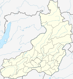 Arakhley Location in Zabaykalsky Krai, Russian Far East | |
| Location | Vitim Plateau, South Siberian System |
| Coordinates | 52°12′10″N 112°52′30″E[1] |
| Primary inflows | Domka, Gryaznukha |
| Primary outflows | Kholoy |
| Catchment area | 242 km2 (93 sq mi) |
| Basin countries | Zabaykalsky Krai, Russia |
| Max. length | 10.8 km (6.7 mi) |
| Max. width | 7 km (4.3 mi) |
| Surface area | 58.5 km2 (22.6 sq mi) |
| Average depth | 10 m (33 ft) |
| Max. depth | 19.5 m (64 ft) |
| Water volume | 0.61 km3 (0.15 cu mi) |
| Surface elevation | 965 m (3,166 ft) |
| Frozen | October to May |
| Islands | None |
| Settlements | Arakhley |
Lake Arakhley is located within the Ivano-Arakhley State Natural Landscape Reserve, a protected area of regional significance created in 1995, covering an area of 210,000 ha (520,000 acres).[2]
Geography
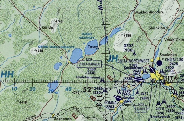
Arakhley lake has a roughly oval shape. It is located in the Beklemishev Depression, at the southeastern end of the Vitim Plateau, west of Chita, Zabaykalsky Krai and lake Kenon. It is separated from neighboring Lake Shaksha by a low, 1.2 km (0.75 mi) wide landspit.
It is part of the Ivan-Arakhley Lake System (Russian: Ивано-Арахлейские озёра), which includes 6 large lakes and about 20 smaller ones. Arakhley is the largest of the group and it is also the lake having the greatest depth.[2][4][5]
There are two small rivers flowing into the lake, the Domka and the Gryaznukha, also known as Shaborta. The Kholoy stream flows out of the lake into Lake Shaksha. The 242 km2 (93 sq mi) catchment area of the lake belongs to the Khilok river basin, a tributary of the Selenga.[2]
 |
Flora and fauna
The lake is surrounded by larch taiga, interspersed with areas of forest steppe and meadows. In the waters there are aquatic plants.[2]
The water of the lake is fresh and the main fish species in it are roach, perch, dace, pike, chebak, "bulus", minnow, crucian carp, peled, bream, carp and catfish. The fauna of the lake has suffered degradation in the past few decades and commercial fisheries have declined.[2]
See also
References
- Google Earth
- Арахле́й - Water of Russia
- "Озеро Арахлей in the State Water Register of Russia". textual.ru (in Russian).
- Энциклопедия Забайкалья - Арахлей, озеро
- "N-49 Chart (in Russian)". Retrieved 30 September 2021.
External links
 Media related to Lake Arakhley at Wikimedia Commons
- «Уху евшие»: На Арахлее стал ловиться крупный чебак
На других языках
- [en] Arakhley (lake)
[fr] Lac Arakhleï
Le lac Arakhleï (en russe : Арахлей озеро) est un lac situé dans le kraï de Transbaïkalie, en Russie et dans la partie sud-est de la Sibérie.[it] Lago Arachlej
Il lago Arachlej (in russo: озеро Арахлей?; in buriato: Арахира нуур, Arachira nuur) è un lago della Russia, situato nel Territorio della Transbajkalia a sud dell'Altopiano del Vitim. Fa parte del sistema di laghi Ivano-Arachlej che consiste di 6 laghi con una superficie d'acqua di oltre 10 km².[ru] Арахлей (озеро)
Арахле́й[1] (бур. Арахира нуур[3]) — самое большое озеро Ивано-Арахлейской системы озёр на юге Витимского плоскогорья в Забайкальском крае. Находится в 40 км к западу от города Читы. Относится к бассейну реки Хилок (правый приток Селенги).Другой контент может иметь иную лицензию. Перед использованием материалов сайта WikiSort.org внимательно изучите правила лицензирования конкретных элементов наполнения сайта.
WikiSort.org - проект по пересортировке и дополнению контента Википедии